
NomadTracks: GPS Map Tracker
Maps & Navigation In-app purchases
Offline GPS tracker for hiking & touring — GPX import and your own paper maps
- Downloads
- 9.2K+
- on Google Play
- Price
- Free
- In-app purchases
- Updated
- Oct 30
- 2026 · v1.28
Screenshots
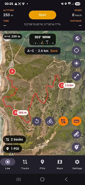


About NomadTracks: GPS Map Tracker
NomadTracks is an offline GPS tracker with offline maps and GPX import for hiking, biking, overlanding, and sailing — with a specialty no other app does this simply: bring your OWN maps. Import a GeoPDF, a scanned topographic map, or even a photo of a paper map, georeference it in the app, and navigate on it fully offline with your live position.
RECORDING
• High-precision GPS recording with accurate elevation (barometer-assisted on supported devices)
• Points of Interest (POIs) with categories, colors, photos, addresses, and notes
• Add POIs manually using lon/lat or UTM coordinates
• Attach photos to your tracks and POIs
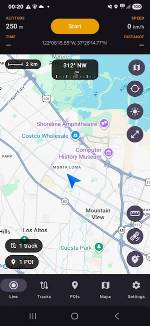
• Live map with scale bar, compass, and coordinates
• Distance measurement on the map
• Live stats in the notification while recording
YOUR OWN MAPS, OFFLINE (our specialty)
• Import georeferenced GeoPDF and PDF maps — they align automatically
• Take a photo of a paper hiking map and georeference it in-app with control points
• Alignment accuracy shown in meters (RMS)
• National-park handouts, alpine club sheets, historic maps — all become live offline maps
• Unlimited maps, free
TRACK NAVIGATION & GHOSTRIDER
• Follow any saved or imported track: distance to the track, distance remaining, and turn cues
• Off-track alerts with sound and vibration — alert radius adjustable per track
• Navigate in either direction, pause any time
• Ghostrider: race your own earlier recording and see live whether you are ahead or behind
• Color tracks by speed or heart rate
IMPORT & EXPORT — NO LOCK-IN
• Import tracks and POIs from GPX, GeoJSON, or bundles
• Export tracks and POIs as GPX, GeoJSON, or bundles with photos and metadata
• Heart rate travels in your GPX files (Garmin format, read by Strava, Komoot & more)
• Open locations in Google Maps
• Share via any app on your phone
YOUR LIBRARY
• Folders for tracks, points of interest, and custom maps
• Search, sort, and filter
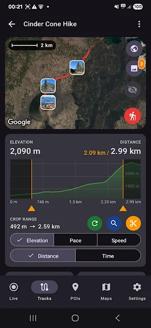
• Elevation, speed, pace, and heart-rate charts for every track
• Edit, recolor, and rate your tracks
• Recently Deleted with 30-day recovery
SYNC & BACKUP
• Dropbox (Pro subscription)
• Synology NAS
• Automatic and manual backups of your entire library
• Backups are portable: move your complete library between NomadTracks on Android and iPhone
MAP PROVIDERS
• Google Maps
• OpenStreetMap (Pro subscription)
• Custom MapLibre (for self-hosters)
• More will be added...
ROUTE PLANNING (Pro subscription)
• Measure and plan routes that follow real roads and trails
• Save a planned route as a track and follow it later
FREE CORE, NO ACCOUNT
• The core — offline GPS recording, unlimited custom maps, GPX import/export, POIs, Synology sync — is free, with no account to create
• No ads, no third-party tracking
• Your data stays on your device and in your own sync targets — never on our servers
• Works fully offline: in the mountains, at sea, off the grid
BUILT FOR 25+ ACTIVITIES
Hiking, trekking, mountain biking, trail running, overlanding, sailing, kayaking, geocaching, ski touring, and more — with metric, imperial, and nautical units.
LANGUAGES
English, Deutsch, Español, Italiano, Français, Português, Magyar
NOMADTRACKS PRO
Unlock route planning, Dropbox sync, and OpenStreetMap basemaps — plus every future Pro feature. (Google Maps and Synology sync are free.)
Subscriptions automatically renew unless cancelled at least 24 hours before the end of the current period. Manage or cancel any time in Google Play → Payments & subscriptions. Payment is charged to your Google account at confirmation of purchase.
———
Privacy Policy: https://www.iubenda.com/privacy-policy/52648882/full-legal
RECORDING
• High-precision GPS recording with accurate elevation (barometer-assisted on supported devices)
• Points of Interest (POIs) with categories, colors, photos, addresses, and notes
• Add POIs manually using lon/lat or UTM coordinates
• Attach photos to your tracks and POIs
• Live map with scale bar, compass, and coordinates
• Distance measurement on the map
• Live stats in the notification while recording
YOUR OWN MAPS, OFFLINE (our specialty)
• Import georeferenced GeoPDF and PDF maps — they align automatically
• Take a photo of a paper hiking map and georeference it in-app with control points
• Alignment accuracy shown in meters (RMS)
• National-park handouts, alpine club sheets, historic maps — all become live offline maps
• Unlimited maps, free
TRACK NAVIGATION & GHOSTRIDER
• Follow any saved or imported track: distance to the track, distance remaining, and turn cues
• Off-track alerts with sound and vibration — alert radius adjustable per track
• Navigate in either direction, pause any time
• Ghostrider: race your own earlier recording and see live whether you are ahead or behind
• Color tracks by speed or heart rate
IMPORT & EXPORT — NO LOCK-IN
• Import tracks and POIs from GPX, GeoJSON, or bundles
• Export tracks and POIs as GPX, GeoJSON, or bundles with photos and metadata
• Heart rate travels in your GPX files (Garmin format, read by Strava, Komoot & more)
• Open locations in Google Maps
• Share via any app on your phone
YOUR LIBRARY
• Folders for tracks, points of interest, and custom maps
• Search, sort, and filter
• Elevation, speed, pace, and heart-rate charts for every track
• Edit, recolor, and rate your tracks
• Recently Deleted with 30-day recovery
SYNC & BACKUP
• Dropbox (Pro subscription)
• Synology NAS
• Automatic and manual backups of your entire library
• Backups are portable: move your complete library between NomadTracks on Android and iPhone
MAP PROVIDERS
• Google Maps
• OpenStreetMap (Pro subscription)
• Custom MapLibre (for self-hosters)
• More will be added...
ROUTE PLANNING (Pro subscription)
• Measure and plan routes that follow real roads and trails
• Save a planned route as a track and follow it later
FREE CORE, NO ACCOUNT
• The core — offline GPS recording, unlimited custom maps, GPX import/export, POIs, Synology sync — is free, with no account to create
• No ads, no third-party tracking
• Your data stays on your device and in your own sync targets — never on our servers
• Works fully offline: in the mountains, at sea, off the grid
BUILT FOR 25+ ACTIVITIES
Hiking, trekking, mountain biking, trail running, overlanding, sailing, kayaking, geocaching, ski touring, and more — with metric, imperial, and nautical units.
LANGUAGES
English, Deutsch, Español, Italiano, Français, Português, Magyar
NOMADTRACKS PRO
Unlock route planning, Dropbox sync, and OpenStreetMap basemaps — plus every future Pro feature. (Google Maps and Synology sync are free.)
Subscriptions automatically renew unless cancelled at least 24 hours before the end of the current period. Manage or cancel any time in Google Play → Payments & subscriptions. Payment is charged to your Google account at confirmation of purchase.
———
Privacy Policy: https://www.iubenda.com/privacy-policy/52648882/full-legal
What’s new
Version 1.28 · Updated October 30, 2026
NEW: Track times in the time zone the track was recorded in NEW: Dropped pins get their elevation from the map NEW: Paste coordinates or a Google/Apple Maps link into the POI editor NEW: Pub and Bar POI categories • Follow button cycles North Up, Compass and Free • Smoother maps and fewer freezes • Bug fixes and stability improvements
User reviews

Sehr zuverlässig und präzise Endlich ein GPS-Tracker, auf den man sich verlassen kann. Selbst in Regionen mit schlechtem Empfang verliert die App das Signal nicht. Das Erstellen und Verfolgen von Routen funktioniert kinderleicht. Großes Lob an die Entwickler!
Alternatives to NomadTracks: GPS Map Tracker
Looking for apps like NomadTracks: GPS Map Tracker? Here are 6 similar Android apps on Google Play. The highest rated is Airport Community (5.0/5), and all 6 are free to download.
-
Mapway: Maps & Transit Planner 3.8
-
ShipAtlas - Vessel Tracker 4.2
-
Skratch: Travel Map & eSIM 4.0
-
TrekSpots | Tent camping map
-
Karta Offline GPS Maps Nav 4.2
-
Airport Community 5.0
| App | Rating | Price | Installs | Last updated | Compare |
|---|---|---|---|---|---|
| NomadTracks: GPS Map Tracker | – | Free | 5,000+ | Oct 30, 2026 | |
| Mapway: Maps & Transit Planner | 3.8 / 5 | Free | 100,000+ | Sep 14, 2026 | Compare |
| ShipAtlas - Vessel Tracker | 4.2 / 5 | Free | 500,000+ | Aug 17, 2026 | Compare |
| Skratch: Travel Map & eSIM | 4.0 / 5 | Free | 100,000+ | Nov 5, 2026 | Compare |
| TrekSpots | Tent camping map | – | Free | 10,000+ | Sep 12, 2026 | Compare |
| Karta Offline GPS Maps Nav | 4.2 / 5 | Free | 10,000,000+ | Apr 21, 2026 | Compare |
| Airport Community | 5.0 / 5 | Free | 100,000+ | Apr 28, 2025 | Compare |
Similar apps on Google Play
- Mapway: Maps & Transit Planner
- ShipAtlas - Vessel Tracker
- Skratch: Travel Map & eSIM
- TrekSpots | Tent camping map
- Karta Offline GPS Maps Nav
- Airport Community
- Save Location GPS - Live Share
- Magic Earth Navigation & Maps
- Avenza Maps: Offline Mapping
- Be Closer: GPS Family Location
- Glympse - Share GPS location
- Hikingbook: Hike, Bike & Run
- Pin Traveler: Travel Tracker
- My Location - Track GPS & Maps
- TwoNav 6: Routes and Maps
- Compass & Altimeter
- Trails Offroad: Offline Maps
- Guru Maps Pro & GPS Tracker
- VoiceMap: Audio Tours & Guides
- Gaggle Paragliding, Ultralight
- Multi-Stop Route Planner
- PeakVisor - 3D Maps & Peaks ID
- TomTom - Maps & Traffic
- GPX Viewer PRO: Hike & Bike
- Geo Tracker - GPS tracker
- Roadie: road trip planner & rv
- Ride with GPS: Bike Navigation
- Map My Ride With GPS Tracker
- WhatsGPS
- FarOut
- My Track
- Tripomatic Planner & Maps
- Territory Helper
- AlpineQuest Explorer Lite
- Weenect - GPS
- Shaka Guide | GPS Audio Tours
- Wanderz - Travel Guides
- Sea Trials - USCG License Exam
- Cyclers: Bike Navigation & Map
- swisstopo
- Footpath Route Planner
- HERE WeGo: Maps & Navigation
- National Park Service
- TrainerRoad
- Gaia GPS: Offline Trail Maps
- Outdooractive. Hike and Ride
- OsmAnd — Maps & GPS Offline
- MAPS.ME: Offline maps GPS Nav
- Mapy.com: Offline Outdoor Maps
- bergfex: Hiking & Tracking
- FindPenguins: Travel Tracker
- myENV
- Bike Citizens Cycling App GPS
- Orca: Boat GPS, Charts, Routes
- Zeo Fast Multi Stop Route Plan
- park4night - Motorhome camper
- SmartGuide: Digital Tour Guide
- komoot - hike, bike & run
- Compass Steel
- Trailforks
- MarineRadar: Vessel Tracker
- Polarsteps
- Aqua Map Boating
- Navionics® Boating
- Bikemap: Cycling Tracker & GPS
- Stasher Luggage Storage
- Big Island Audio Tour Guide
- Holland America Line Navigator
- izi.TRAVEL: Audio Tour Guides
- VesselFinder
- Yr
- BaseMap: 3D Hunting Maps & GPS
- MixerBox BFF: Location Tracker