
RF Link - Signal Strength, LOS
Pinchi Tools In-app purchases
Path loss, link budget, RF calculator, line of sight, Fresnel, VHF UHF microwave
- Rating
- 2.0
- 74 ratings
- Downloads
- 7K+
- on Google Play
- Price
- Free
- In-app purchases
- Updated
- Sep 17
- 2026 · v3.0.3
Screenshots
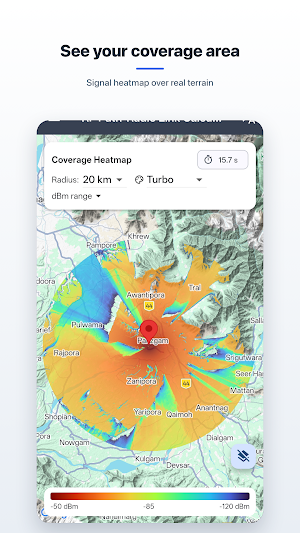
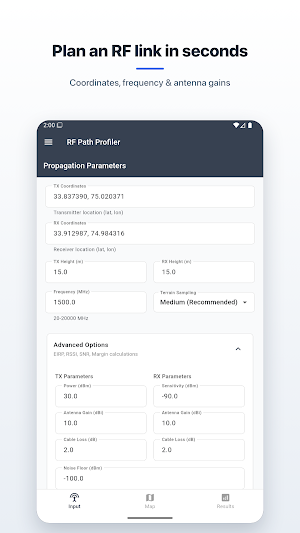
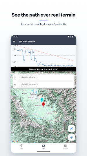


About RF Link - Signal Strength, LOS
RF Path Profiler App provides professional-grade RF Path, RLOS, Fresnel Zone and Path Loss analysis using the Longley-Rice (ITM) radio propagation model. Designed for telecom engineers, RF planners, broadcasters, and wireless network designers, the app delivers highly accurate point-to-point link evaluation for frequencies ranging from 20 MHz to 20 GHz.
Whether you're planning microwave links, Wi-Fi backhauls, LOS radio links, or long-distance wireless communication, this app helps predict terrain impact, path loss, and link feasibility with exceptional accuracy.
⭐ Key Features
🔹 ITM Longley-Rice Model (20 MHz – 20 GHz)
• Industry-standard Irregular Terrain Model
• Accurate diffraction, scatter & line-of-sight predictions
• Supports multiple reliability × confidence combinations
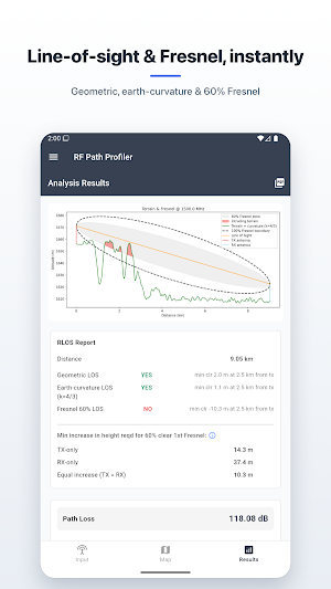
🔹 RLOS (Radio Line-of-Sight) Analysis
• Geometric LOS check
• Earth-curvature LOS (k-factor adjustable)
• 60% first Fresnel zone clearance
• Minimum clearance at obstruction points
• Required tower height increase suggestions
🔹 Terrain Elevation Profiling
• High-resolution elevation sampling
• Plots include terrain, curvature, LOS and Fresnel zones
• Quick zoomable charts with sharing options
🔹 Path Loss & Link Budget
• Path loss predictions
• EIRP, RSSI, SNR and link margin calculations
• Clear pass/warning/fail indicators
🔹 Clean & Intuitive Interface
• Fast computation
• Simple map-based TX/RX selection
• PDF report export
• Plot image sharing & saving
⭐ Ideal For
• Wireless network planners
• Microwave / LOS link engineers
• UAV/Drone communication designers
• Amateur radio operators
• Students learning RF & propagation models
User reviews

It gives good accurate results!

Perfect.
Alternatives to RF Link - Signal Strength, LOS
Looking for apps like RF Link - Signal Strength, LOS? Here are 6 similar Android apps on Google Play. The highest rated is Trails Offroad: Offline Maps (4.6/5), and all 6 are free to download.
-
Radio Garden 4.4
-
Airthings 4.5
-
The Pattern: Astrology 4.1
-
Trails Offroad: Offline Maps 4.6
-
Sygic GPS Navigation & Maps 4.1
-
IPVanish VPN: Fast & Secure 4.4
| App | Rating | Price | Installs | Last updated | Compare |
|---|---|---|---|---|---|
| RF Link - Signal Strength, LOS | 2.0 / 5 | Free | 5,000+ | Sep 17, 2026 | |
| Radio Garden | 4.4 / 5 | Free | 10,000,000+ | Sep 23, 2025 | Compare |
| Airthings | 4.5 / 5 | Free | 100,000+ | Sep 16, 2026 | Compare |
| The Pattern: Astrology | 4.1 / 5 | Free | 1,000,000+ | Sep 15, 2026 | Compare |
| Trails Offroad: Offline Maps | 4.6 / 5 | Free | 100,000+ | Sep 28, 2026 | Compare |
| Sygic GPS Navigation & Maps | 4.1 / 5 | Free | 50,000,000+ | Oct 7, 2026 | Compare |
| IPVanish VPN: Fast & Secure | 4.4 / 5 | Free | 10,000,000+ | Oct 21, 2026 | Compare |
Similar apps on Google Play
- Radio Garden
- Airthings
- The Pattern: Astrology
- Trails Offroad: Offline Maps
- Sygic GPS Navigation & Maps
- IPVanish VPN: Fast & Secure
- TomTom - Maps & Traffic
- NetShare - no-root-tethering
- Detecht - Motorcycle App & GPS
- Bria Mobile: VoIP Softphone
- My Location - Track GPS & Maps
- Yesim: eSIM & Mobile Data
- Mergin Maps: QGIS in pocket
- NetShare+ Wifi Tether
- WiFi Detector: Who Use My WiFi
- Geo Tracker - GPS tracker
- AntennaPod - Podcast Player
- Magic Earth Navigation & Maps
- WhatsGPS
- MarineRadar: Vessel Tracker
- INKBIRD
- 17TRACK Package Tracker
- Chipolo
- Zeno Radio
- Guru Maps Pro & GPS Tracker
- NETGEAR Orbi – WiFi System App
- Karta Offline GPS Maps Nav
- CyberTrophy
- MAPS.ME: Offline maps GPS Nav
- Linksys
- Satellite Director
- Plane Finder - Flight Tracker
- OsmAnd — Maps & GPS Offline
- Next Spaceflight
- TomTom GO Expert: Truck GPS
- phyphox
- Offline Map Navigation
- Signal Detector
- FindPenguins: Travel Tracker
- Wanderz - Travel Guides
- Gaia GPS: Offline Trail Maps
- Voice GPS & Driving Direction
- Be Closer: GPS Family Location
- AlpineQuest Explorer Lite
- swisstopo
- Freetour.com - travel app
- GPX Viewer PRO: Hike & Bike
- Applied Ballistics Quantum
- Learn Ethical Hacking
- ShipAtlas - Vessel Tracker
- FarOut
- Opensignal - 5G, 4G Speed Test
- Mapway: Maps & Transit Planner
- JollyTango: Audio Travel Guide
- New Scientist
- Radarbot: Radar Detector, GPS
- HiiKER: The Offline Hiking app
- Orca: Boat GPS, Charts, Routes
- Multi-Stop Route Planner
- Trace+: Afro-Urban Culture
- Nokia WiFi
- Anti Spy Detector - Spyware
- WiFi Analyzer (open-source)
- HERE WeGo: Maps & Navigation
- Flip Sampler
- FlexiRoam: eSIM & Data Plans
- Go City: Travel Plan & Tickets
- WiFiman
- Mapy.com: Offline Outdoor Maps
- Tooly Toolbox All Tools In One
- TourRadar: Tours & Adventures
- Building Tools
- Earth 3D Map-StreetView Camera
- Speediance - Home Workout
- Glympse - Share GPS location
- PeakVisor - 3D Maps & Peaks ID
- Sound meter : SPL & dB meter
- Froling Connect
- Oddysee: AI Map & Trip Planner
- Kraken Pro: Crypto & Stocks
- Headout: Travel Experiences
- My Track
- Most Common Russian Words
- OONI Probe
- what3words: Navigation & Maps
- Simpro Mobile
- GSMArena
- SPYPOINT
- ZUMIMALL
- Orion Intelligence
- NebulaBuds
- Wi-Fi Toolkit
- Specialized
- NASA
- Outdooractive. Hike and Ride
- ASUS Router
- IronVest - Security & Privacy
- Snipd | AI Podcast Player
- RDTunnel.Pro- Super fast Net
- Frequency Sound Generator
- MarineTraffic - Ship Tracking
- A Better Routeplanner (ABRP)
- Ride with GPS: Bike Navigation
- Solar Walk 2 Ads+:Solar System
- TravelAnimator・Journey Route
- Seed4.Me VPN Proxy
- Compass & Altimeter
- Planes Live - Flight Tracker
- AstroSoul: Astro Palm Reader
- Cyclers: Bike Navigation & Map
- Sea Trials - USCG License Exam
- Zeo Fast Multi Stop Route Plan
- onX Offroad: Trail Maps & GPS