About Shorewise
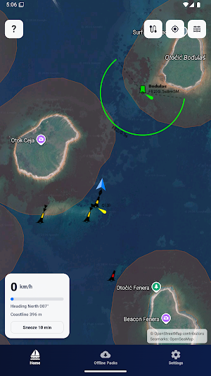
Shorewise brings shore-distance awareness, speed guidance, marine weather, route planning, anchor monitoring, and useful boating places together in one clear map for the Croatian Adriatic.
Built for tourists, charter guests, skippers, and local boaters who want a clearer picture of what is happening around their boat.
KEY FEATURES
• See your live position, speed, and heading
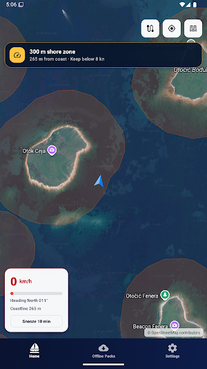
• Monitor distance from the nearest coastline
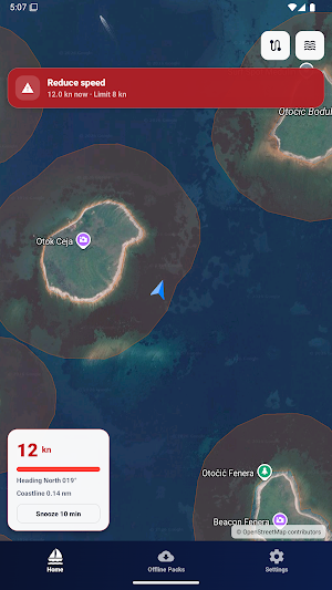
• Receive visual, sound, and vibration alerts in near-shore zones
• Choose your vessel type for relevant distance and speed references
• Check current marine weather, wind, waves, and sea conditions
• Explore 24–48 hour wind, gust, and wave forecasts
• Identify calmer departure windows and changing conditions
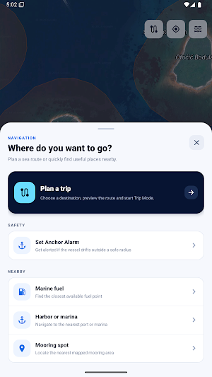
• Plan routes and follow journey progress with Trip Mode
• Monitor movement around your anchor position with Anchor Alarm
• Find nearby fuel stations, harbors, marinas, anchorages, and mooring spots
• View services, contact details, VHF information, opening hours, and other destination data when available
• Download regional packs for offline coastline awareness
• Continue supported monitoring while the app is in the background
TRIP MODE
Plan a destination and follow your journey with remaining distance, estimated arrival time, elapsed time, distance traveled, and route progress displayed on the map.
ANCHOR ALARM
Set your anchor position and choose an allowed movement radius. Shorewise monitors your position and alerts you if the boat moves outside the selected area.
SMARTER MARINE WEATHER
Review current conditions and hourly wind, gust, and wave forecasts. Shorewise helps you understand how conditions may develop before departure and during your expected journey.
USEFUL BOATING PLACES
Explore marinas, harbors, fuel stations, anchorages, and mooring spots. Available information may include services, fuel types, VHF channels, phone numbers, websites, opening hours, distance, and estimated arrival time.
MADE FOR THE ADRIATIC
Shorewise focuses on Croatia’s coastline, islands, bays, marinas, harbors, fuel stops, and near-shore boating conditions. It is useful whether you are renting a boat for a day, spending several weeks on charter, or boating regularly throughout the season.
FREE FEATURES INCLUDE:
• Live position, speed, and heading
• Shore-distance awareness
• Basic near-shore alerts
• Current marine weather
• Map and boating-place exploration
• Basic offline regional coastline packs
PREMIUM ACCESS INCLUDES:
• Vessel-specific distance and speed references
• Background monitoring
• Anchor Alarm
• Trip Mode and route planning
• Detailed marine forecasts and charts
• Departure-window and changing-condition guidance
• Nearby boating-place tools and richer destination details
• Advanced map overlays
• Alert customization
• Offline access to the most recently loaded forecast
Premium is available as a 3-Day Pass, Monthly plan, or Season Pass.
IMPORTANT SAFETY NOTE
Shorewise is a boating awareness and planning tool. It is not a certified marine navigation system, official nautical chart, weather or legal authority, or replacement for local regulations, official notices, safe seamanship, or your own judgment.
Routes, forecasts, distances, references, destination details, and alerts may be incomplete, delayed, or inaccurate. Always follow posted rules, official maritime and weather information, local restrictions, and instructions from relevant authorities.
Terms of Use:
https://shorewise.app/terms
Privacy Policy:
https://shorewise.app/privacy
Similar Apps
Sea Trials - USCG License Exam
Upgrade USCG License

onWater Fish - Fishing Spots
Fishing points, maps, weather forecasts, property boundaries, & usgs streamflows
MarineRadar: Vessel Tracker
Marine Radar: Worldwide Live Ship Info with Marine Traffic's AIS coverage.

Nautide: Tides, Wind, Waves +
Plan and enjoy the activities at sea: surf, fishing, sailing, diving, kayak ...

VesselFinder
Real time AIS ship tracking of marine traffic, vessel database, ship photos.

Orca: Boat GPS, Charts, Routes
The Ultimate Boating App - Marine charts, Sail Routes, AIS, GPS, Weather & more
