
Vanguard Compass: Tactical GPS
Tools In-app purchases Contains ads
Military-grade offline compass, GNSS satellite radar & navigation & survival kit
- Downloads
- 80+
- on Google Play
- Price
- Free
- In-app purchases
- Updated
- Sep 3
- 2026 · v1.1.0
Screenshots
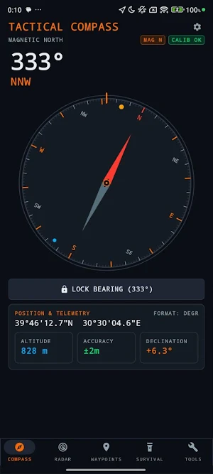
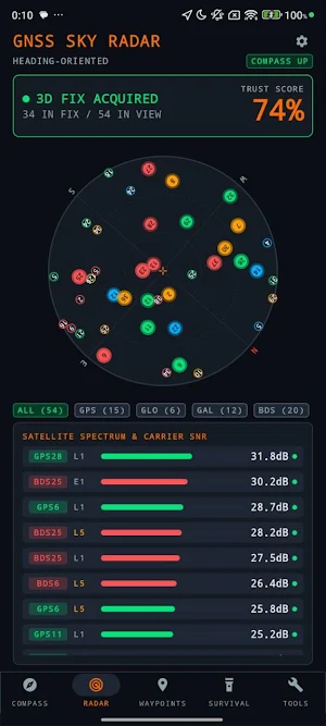
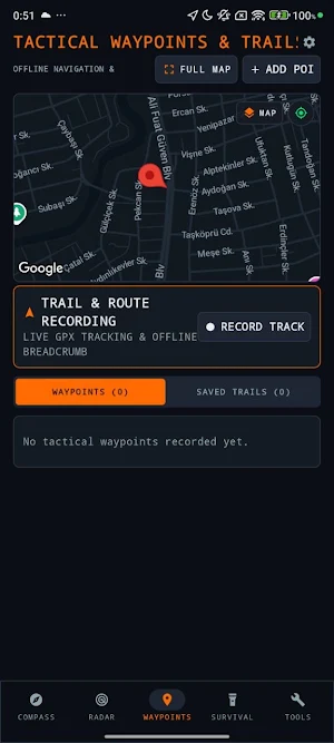

About Vanguard Compass: Tactical GPS
Tailored for hikers, mountaineers, field operators, search-and-rescue teams, and outdoor explorers, Vanguard Compass delivers mission-critical orientation, route recording, and telemetry without relying on cellular networks, Wi-Fi, or cloud accounts.
CORE MODULES & CAPABILITIES
🧭 1. SENSOR-FUSED TACTICAL COMPASS
• Ultra-smooth 60/120 FPS heading tracking powered by hardware Rotation Vector, Gyroscope, and Accelerometer fusion.
• Instant switching between True North and Magnetic North.
• Integrated World Magnetic Model (WMM) for precise real-time magnetic declination computation.
• Bearing Lock (Sight Compass): Lock onto target azimuth with live visual deviation pointers and haptic vibration cues.
• Real-time Celestial Azimuth: Live Sun and Moon azimuth positions rendered directly onto the compass bezel.
• Military Grid Support: Seamless coordinate readouts in MGRS, UTM, and WGS84 (Decimal & DMS).
🛰️ 2. GNSS & GPS SATELLITE SKYVIEW RADAR
• Live Polar SkyPlot: Real-time visual tracking of active satellites overhead mapped by Azimuth (0–360°) and Elevation (0–90°).
• Multi-Constellation Support: GPS (USA), GLONASS (Russia), GALILEO (EU), BEIDOU (China), QZSS (Japan), and SBAS.
• Signal-to-Noise Telemetry: Satellite-level C/N0 (dB-Hz) signal metrics with L1 and L5 dual-frequency band differentiation.
• GNSS Trust Score: Dynamic 0–100 reliability index based on fix geometry, active constellation count, and horizontal accuracy.
📍 3. TACTICAL MAPS, WAYPOINTS & TRAIL TRACKER
• High-Definition Tactical Maps: Seamlessly switch between Tactical Dark and Satellite Hybrid map layers with automatic offline disk caching.
• Live GPS Route & Trail Recording: High-fidelity breadcrumb track logging for hiking, trekking, and backcountry navigation.
• Interactive Elevation Profile: Touch-scrub terrain altitude curves with real-time elevation gain (▲), descent loss (▼), min/max altitude, and live map position cursor.
• Live Performance Telemetry: Monitor duration, distance, instant speed, and average speed analytics in real time.
• Tactical Waypoints (POI): Mark and store critical points (Camp, Vehicle, Water Source, Evac Point) in a secure local database without internet access.
• Tactical Guidance Radar: Direct range (meters/km) and relative bearing arrow to your selected destination.
• GPX Route Export & Sharing: Export your recorded routes in standard GPX format to share with external GPS units or team members.
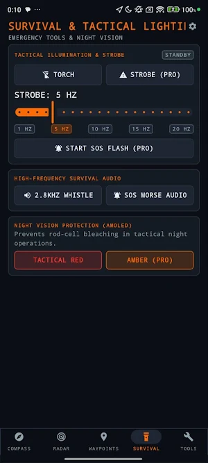
🔦 4. TACTICAL & SURVIVAL LIGHTING
• High-Output Tactical Torch: Reliable maximum-lumen illumination.
• Variable Frequency Strobe: Adjustable 1 Hz to 20 Hz signaling and disorienting tactical defense strobe.
• Automated SOS Morse Beacon: Loops international standard emergency distress code (... --- ...) via camera flash.
• Tactical Red & Amber Screen Mode: Full-screen night-vision preservation mode protecting dark-adapted rod photoreceptors.
• High-Frequency Audio SOS & Survival Whistle.
📐 5. FIELD & ENVIRONMENTAL INSTRUMENTS
• Dual-Axis Clinometer: Precision pitch and roll inclinometer for slope angles, vehicle tilt, and topography measurement.
• 2D Bullseye Surface Level: 360° circular surface level for campsite leveling and antenna alignment.
• Barometric Altimeter & Weather Barometer: Real-time atmospheric pressure (hPa / inHg), trend indicator, and barometric altitude.
• Ephemeris Dashboard: Sunrise, sunset, civil/nautical/astronomical twilight schedules, and moon phase calculations.
PRIVACY & POWER EFFICIENCY
• 100% Offline Core: Coordinates, waypoints, and recorded trails never leave your physical device.
• Zero Data Collection: Complete operational privacy with no account registration required.
• Tactical AMOLED Black: Deep OLED pixel deactivation for extended battery life in harsh field environments.
What’s new
Version 1.1.0 · Updated September 3, 2026
What's new in 1.1.0: • Tactical Waypoints & Trail Tracker — record live hiking and biking routes with adaptive GPS breadcrumbs • Google Maps — toggle Tactical Dark and Satellite Hybrid layers • Interactive Elevation Profile — gain, loss, and touch-scrub altitude • Live Telemetry — distance, duration, instant and average speed • GPX Export & Share — standard GPX track files • Portrait-locked UI for stable field use • Localization and performance improvements
User reviews

kullanışlı
Alternatives to Vanguard Compass: Tactical GPS
Looking for apps like Vanguard Compass: Tactical GPS? Here are 6 similar Android apps on Google Play. The highest rated is Digital Compass (4.7/5), and 5 of the 6 are free to download.
-
Sleep Number 4.3
-
Klarstein 3.2
-
beurer HealthManager Pro 2.8
-
Guru Maps Pro & GPS Tracker 4.5
-
Digital Compass 4.7
-
Ride with GPS: Bike Navigation 4.6
| App | Rating | Price | Installs | Last updated | Compare |
|---|---|---|---|---|---|
| Vanguard Compass: Tactical GPS | – | Free | 50+ | Sep 3, 2026 | |
| Sleep Number | 4.3 / 5 | Free | 1,000,000+ | Sep 15, 2026 | Compare |
| Klarstein | 3.2 / 5 | Free | 100,000+ | Sep 15, 2026 | Compare |
| beurer HealthManager Pro | 2.8 / 5 | Free | 500,000+ | Oct 16, 2026 | Compare |
| Guru Maps Pro & GPS Tracker | 4.5 / 5 | 89.99 USD | 50,000+ | Sep 30, 2026 | Compare |
| Digital Compass | 4.7 / 5 | Free | 10,000,000+ | Jul 28, 2026 | Compare |
| Ride with GPS: Bike Navigation | 4.6 / 5 | Free | 1,000,000+ | Oct 19, 2026 | Compare |
Similar apps on Google Play
- Sleep Number
- Klarstein
- beurer HealthManager Pro
- Guru Maps Pro & GPS Tracker
- Digital Compass
- Ride with GPS: Bike Navigation
- mySolarEdge
- Simpro Mobile
- Tyfoom | Engagement Platform
- FarOut
- Emporia Energy
- SkySafari Astronomy
- Expand: Beyond Meditation
- Compass & Altimeter
- Weather Live
- Aqua Map Boating
- Sea Trials - USCG License Exam
- GPX Viewer PRO: Hike & Bike
- Compass Steel 3D
- Carp Pilot Pro
- BaseMap: 3D Hunting Maps & GPS
- Hikingbook: Hike, Bike & Run
- Orca: Boat GPS, Charts, Routes
- Detecht - Motorcycle App & GPS
- swisstopo
- Skratch: Travel Map & eSIM
- OneSoil Scouting: Farming Tool
- Compass Steel
- Tripomatic Planner & Maps
- SOLARMAN Smart
- AlpineQuest Explorer Lite
- Narwal
- INKBIRD
- SPYPOINT
- Valamar
- Weather Forecast & Widget
- Rivercast - River Levels App
- Wavve Boating: Marine Boat GPS
- Sound meter : SPL & dB meter
- HiiKER: The Offline Hiking app
- bergfex: Hiking & Tracking
- Chipolo
- Applied Ballistics Quantum
- Daypad - Simple Time Tracker
- ShipAtlas - Vessel Tracker
- My Hurricane Tracker Pro
- Hello Aurora: Aurora Forecast