

AxisTrack LandXML Survey
Ertan Selcuk Atalay Navigation iPhoneiPadiPod touch
AxisTrack LandXML Survey is a free Navigation app for iPhone and iPad by Ertan Selcuk Atalay. Requires iOS 13.0. Updated June 3, 2026.
- Price
- Free
- on the App Store
- Size
- 57 MB
- Age 4+
- Updated
- Jun 3
- 2026 · v1.2.1
Screenshots


About AxisTrack LandXML Survey
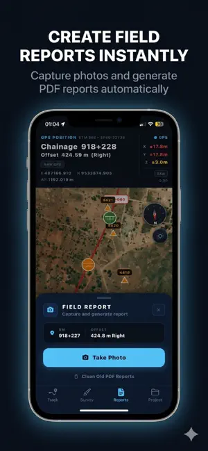
AxisTrack is a professional mobile LandXML and field engineering platform built for surveyors, civil engineers and infrastructure field teams. Designed for real field operations, AxisTrack helps engineering teams work directly with alignments, chainage/offset navigation, cross-sections and coordinate systems on-site. Unlike generic GPS or GIS apps, AxisTrack focuses on infrastructure engineering workflows. LANDXML WORKFLOWS • Import and analyze LandXML projects • Support for alignment-based field operations • Horizontal and vertical geometry support • Multi-alignment project management • Fast mobile project access in the field FIELD ENGINEERING TOOLS • Real-time chainage and offset positioning • Alignment navigation and station control • Cross-section visualization • Cut/fill and as-built verification workflows • PDF field reporting with photos GLOBAL CRS SUPPORT AxisTrack includes: • 197 countries • 4893 coordinate systems • UTM systems • National grids • Local coordinate system workflows Coordinate workflows are designed for international railway, highway and infrastructure projects. FIELD OPERATIONS • KML/KMZ project overlays • Offline field workflows • External GNSS support • NTRIP compatibility • Background positioning support BUILT FOR PROFESSIONALS Used in: • Railway projects • Highway construction • Infrastructure field operations • Earthwork and grading workflows • Alignment control operations IMPORTANT Positioning accuracy may vary depending on hardware, environment and correction infrastructure. Critical engineering measurements should always be verified using approved survey equipment and professional survey methods. Privacy Policy: https://esanetsoft.com/privacy
What’s new
Version 1.2.1 · Updated June 3, 2026
Version 1.2.1 • Added cross-section area & volume calculations • Improved global CRS reliability • Better country → CRS workflow • Faster project loading and map performance • Improved large LandXML handling • Better offline and memory performance • Enhanced cross-section experience • Improved alignment navigation • Stability improvements and bug fixes
App privacy
The developer, Ertan Selcuk Atalay, reported these privacy practices to Apple.
Data Not Collected
The developer does not collect any data from this app.
Alternatives to AxisTrack LandXML Survey
Looking for apps like AxisTrack LandXML Survey? Here are 6 similar apps on the App Store. The highest rated is MapLab Survey - GIS, CAD, Land (5.0/5), and all 6 are free to download.





| App | Rating | Price | Last updated | Compare |
|---|---|---|---|---|
| AxisTrack LandXML Survey | – | Free | June 3, 2026 | |
| Jeomatik | – | Free | Sep 30, 2026 | Compare |
| KeMaL | – | Free | Apr 23, 2026 | Compare |
| MapLab Survey - GIS, CAD, Land | 5.0 / 5 (6) | Free | Aug 18, 2026 | Compare |
| VIA - Field Positioning | – | Free | Oct 11, 2026 | Compare |
| Coordinator’s | – | Free | Jul 19, 2026 | Compare |
| RBMIMS | – | Free | Jul 27, 2026 | Compare |