

JeoNavigator
Erdinc Orsan Unal Navigation iPhoneiPadiPod touch
JeoNavigator is a free Navigation app for iPhone and iPad by Erdinc Orsan Unal. Requires iOS 17.0. Updated November 8, 2026.
- Price
- Free
- on the App Store
- Size
- 5 MB
- Age 4+
- Updated
- Nov 8
- 2026 · v2.0
Screenshots


About JeoNavigator
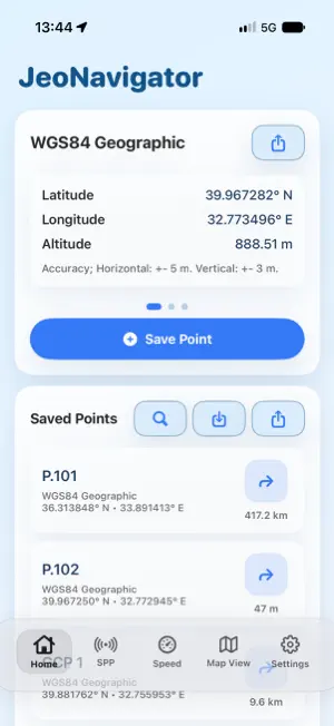
JeoNavigator is a field companion for live GPS coordinates, coordinate conversion, saved field points and guidance to targets on the map. FROM POINTS TO ROUTES Connect saved points to create a pipeline route. Choose the start, drag points into the required connection order or reverse the direction. Check the map preview and share the route as a KML file containing one open line. COORDINATES AND FIELD RECORDING • View latitude, longitude, altitude and location accuracy. • Work with WGS84, ITRF96, ED50, NAD83, ETRS89, UTM, TM and Web Mercator coordinate options. • Keep frequently used coordinate systems in your favorites. • Save, edit and search points; record points automatically at distance or time intervals. FILES, MAPS AND TARGET GUIDANCE • Import CSV, KML and KMZ; share points as CSV or KML. • Display KML/KMZ lines and polygons on the map. • Use map basemaps and imported offline MBTiles files. • Use stakeout and camera-based AR guidance toward selected points. • Follow the active target with Live Activity on compatible devices. • View GPS speed, selected geoid/elevation services and bathymetry information when available. Language options: Turkish, English, German, Russian, Italian, Chinese, Japanese, Spanish, Korean, French and Czech. Location accuracy depends on your device and field conditions. Online maps and data services require an internet connection. Bathymetry information does not replace official nautical charts. Preview a driving route to a saved field point and start turn-by-turn voice guidance. The route is recalculated if you go off course. On a compatible Apple CarPlay display, select saved destinations and see your route, maneuvers, remaining distance, weather, and estimated arrival time. Switch map views and check live coordinates, speed, and distance to saved points. The analog clock adapts to day and night appearances. If a field point lies off a drivable road, the driving route may not reach the exact destination.
What’s new
Version 2.0 · Updated November 8, 2026
• Preview a driving route to a saved field point and start turn-by-turn voice guidance. The route is recalculated if you go off course. • On a compatible Apple CarPlay display, select saved destinations and see your route, maneuvers, remaining distance, and estimated arrival time. • Switch map views and check live coordinates, speed, and distance to saved points. The analog clock adapts to day and night appearances. • Interface text for navigation, coordinates, GPS accuracy, and point management has been improved in 11 languages.
App privacy
The developer, Erdinc Orsan Unal, reported these privacy practices to Apple.
Data Not Collected
The developer does not collect any data from this app.
Alternatives to JeoNavigator
Looking for apps like JeoNavigator? Here are 6 similar apps on the App Store. The highest rated is MineAR: Augmented Reality Map (5.0/5), and 5 of the 6 are free to download.
-
 AxisTrack LandXML Survey
-
 MapLab Survey - GIS, CAD, Land
4.8
-
 KML & KMZ Files Viewer
1.5
-
 MineAR: Augmented Reality Map
5.0
-
 GlobalStay
5.0
-
 Landsight: Land Area Measure
| App | Rating | Price | Last updated | Compare |
|---|---|---|---|---|
| JeoNavigator | – | Free | November 8, 2026 | |
| AxisTrack LandXML Survey | – | Free | Jun 3, 2026 | Compare |
| MapLab Survey - GIS, CAD, Land | 4.8 / 5 (10) | Free | Aug 18, 2026 | Compare |
| KML & KMZ Files Viewer | 1.5 / 5 (2) | 0.99 USD | Aug 6, 2025 | Compare |
| MineAR: Augmented Reality Map | 5.0 / 5 (5) | Free | Apr 23, 2025 | Compare |
| GlobalStay | 5.0 / 5 (1) | Free | Oct 21, 2026 | Compare |
| Landsight: Land Area Measure | – | Free | Nov 3, 2026 | Compare |
Compare JeoNavigator with the top alternatives: ratings, updates, ASO score and keyword gaps →