

VIA - Field Positioning
Ed Stanyer Navigation iPhoneiPadiPod touch
VIA - Field Positioning is a free Navigation app for iPhone and iPad by Ed Stanyer. Requires iOS 16.4. Updated October 11, 2026.
- Price
- Free
- on the App Store
- Size
- 80 MB
- Age 4+
- Updated
- Oct 11
- 2026 · v1.2.2
Screenshots
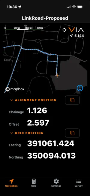


About VIA - Field Positioning
VIA is a field positioning application designed for use on civil engineering projects and other surveying and GIS workflows. It makes coordinate, alignment and location information readily available in the field. VIA combines live device positioning with project coordinate systems and geometric alignments. Your current position can be displayed as grid coordinates and, when an alignment is selected, as chainage (station) and offset. Survey and GIS data can be captured in the field, either by recording individual points or automatically while moving through the site. Captured data can be exported in common formats for use in surveying, GIS, CAD and other engineering workflows. Display conventions can be configured to suit different working practices, including coordinate order, alignment terminology and distance formatting. VIA is designed to keep common field tasks straightforward while providing the coordinate, alignment and survey information needed in the field. VIA's Calculate tools convert between grid coordinates and alignment positions expressed as chainage (station) and offset. Locations can be recorded individually or captured automatically at regular intervals. Notes can be added to recorded locations to provide useful context, and recorded locations can be reviewed on the map and exported for use in other systems. VIA can also create an alignment from a sequence of recorded positions. Recorded locations can be exported as geographic or grid coordinates in CSV format, or as KML for use with mapping applications. Recorded alignments can be exported as LandXML. VIA stores recorded data, alignments and application settings locally on the device. It does not require a VIA account or connection to a Code Workshop service. VIA. Navigate. Calculate. Record.
What’s new
Version 1.2.2 · Updated October 11, 2026
Added satellite and hybrid map views for improved field navigation. Engineering alignments and survey points can now be displayed over satellite imagery. Map preferences are saved automatically. Minor performance and stability improvements.
App privacy
The developer, Ed Stanyer, reported these privacy practices to Apple.
Data Not Linked to You
The following data, which may be collected but is not linked to your identity, may be used for the following purposes:
- Location: Precise Location, Coarse Location
- Identifiers: User ID
- Usage Data: Product Interaction, Other Usage Data
- Diagnostics: Performance Data, Other Diagnostic Data
Used for: Analytics, App Functionality
Alternatives to VIA - Field Positioning
Looking for apps like VIA - Field Positioning? Here are 6 similar apps on the App Store. The highest rated is BeeLine Radio Cars Scarborough (5.0/5), and all 6 are free to download.
-
 AxisTrack LandXML Survey
-
 MetroSmart
-
 BeeLine Radio Cars Scarborough
5.0
-
 The Crane Resort
4.8
-
 VendElectric
-
 East Yorkshire Buses
4.8
| App | Rating | Price | Last updated | Compare |
|---|---|---|---|---|
| VIA - Field Positioning | – | Free | October 11, 2026 | |
| AxisTrack LandXML Survey | – | Free | Jun 3, 2026 | Compare |
| MetroSmart | – | Free | Sep 7, 2026 | Compare |
| BeeLine Radio Cars Scarborough | 5.0 / 5 (1) | Free | Sep 5, 2025 | Compare |
| The Crane Resort | 4.8 / 5 (131) | Free | Apr 16, 2026 | Compare |
| VendElectric | – | Free | Oct 26, 2023 | Compare |
| East Yorkshire Buses | 4.8 / 5 (23) | Free | Oct 2, 2026 | Compare |