
GPS Land - Measure Field Area
U09Code Apps Productivity Contains ads
Measure multiple land area, field size, and distances on the map using GPS.
- Downloads
- 552+
- on Google Play
- Price
- Free
- No in-app purchases
- Updated
- Jun 19
- 2026
Screenshots



About GPS Land - Measure Field Area
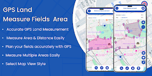
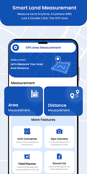
GPS Land - Measure Field Area 🗾🗾 is a powerful and easy-to-use application that helps you measure land, fields, and multiple areas on a map accurately and quickly using GPS.
You can calculate land area, measure distances, and track field boundaries with high precision.
This app is especially useful for farmers, real estate agents, engineers, surveyors, and outdoor enthusiasts who need a reliable GPS area calculator and distance measurement tool.
Measure Field Area 🌏🌏 allows you to calculate GPS area and GPS distance with great accuracy. You can mark specific locations using POI points, making the process fast, simple, and user-friendly.
Just select the area on the map, and the total calculation will appear instantly on the screen. You can also measure and manage multiple areas at the same time.
After completing a measurement, you can save it by adding a measurement name and description, allowing you to view and manage your measurement history anytime.
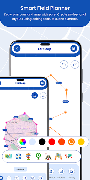
Field planner useful for map view to draw field boundaries, mark land areas, or plan crop/project layouts by adding text, stickers, shapes with colors, photo and export projects.
🎇 Features :-
🗺 Measure land and field area accurately using GPS.
🗺️ GPS distance measurement tool for roads, paths, and boundaries.
🗺️ Measure distances directly on the map.
🗺️ Field planner for map, draw, edit & share land projects.
🗺️ Measure area and distance on satellite, hybrid, normal, terrain, retro, night maps.
🗺️ Accurate GPS area calculator with multiple unit options.
🗺️ Measure multiple areas simultaneously.
🗺️ Easy-to-use interface with zoom in/out, polygon drawing, color options, redo & undo.
🗺️ Polygon area calculator for irregular land boundaries.
🗺️ Multiple units supported: m², acres, hectares, km, feet, miles, and more.
🗺️ Convert measurements between different units.
🗺️ Ideal for farmers, engineers, and real estate professionals.
🗺️ Save field measurements and POI locations for future reference.
🗺️ GPS timestamp to capture live location tags on photos.
🗺️ Customizable stamp camera with location, date/time, address, and background color.
🗺️ Built-in compass with normal, map, and camera compass modes.
🗺️ Save and share area and distance measurement results easily.
🎇 Permission :-
📍 Location permission to get current location and display in map and draw path on map based on location.
📍 Storage permission to save your measured areas along with description.
📍 Camera permission to capture stamp photos.
You can calculate land area, measure distances, and track field boundaries with high precision.
This app is especially useful for farmers, real estate agents, engineers, surveyors, and outdoor enthusiasts who need a reliable GPS area calculator and distance measurement tool.
Measure Field Area 🌏🌏 allows you to calculate GPS area and GPS distance with great accuracy. You can mark specific locations using POI points, making the process fast, simple, and user-friendly.
Just select the area on the map, and the total calculation will appear instantly on the screen. You can also measure and manage multiple areas at the same time.
After completing a measurement, you can save it by adding a measurement name and description, allowing you to view and manage your measurement history anytime.
Field planner useful for map view to draw field boundaries, mark land areas, or plan crop/project layouts by adding text, stickers, shapes with colors, photo and export projects.
🎇 Features :-
🗺 Measure land and field area accurately using GPS.
🗺️ GPS distance measurement tool for roads, paths, and boundaries.
🗺️ Measure distances directly on the map.
🗺️ Field planner for map, draw, edit & share land projects.
🗺️ Measure area and distance on satellite, hybrid, normal, terrain, retro, night maps.
🗺️ Accurate GPS area calculator with multiple unit options.
🗺️ Measure multiple areas simultaneously.
🗺️ Easy-to-use interface with zoom in/out, polygon drawing, color options, redo & undo.
🗺️ Polygon area calculator for irregular land boundaries.
🗺️ Multiple units supported: m², acres, hectares, km, feet, miles, and more.
🗺️ Convert measurements between different units.
🗺️ Ideal for farmers, engineers, and real estate professionals.
🗺️ Save field measurements and POI locations for future reference.
🗺️ GPS timestamp to capture live location tags on photos.
🗺️ Customizable stamp camera with location, date/time, address, and background color.
🗺️ Built-in compass with normal, map, and camera compass modes.
🗺️ Save and share area and distance measurement results easily.
🎇 Permission :-
📍 Location permission to get current location and display in map and draw path on map based on location.
📍 Storage permission to save your measured areas along with description.
📍 Camera permission to capture stamp photos.
What’s new
Updated June 19, 2026
* Known Bug Fixed.
Alternatives to GPS Land - Measure Field Area
Looking for apps like GPS Land - Measure Field Area? Here are 6 similar Android apps on Google Play. The highest rated is OneSoil Scouting: Farming Tool (4.6/5), and 4 of the 6 are free to download.
-
OneSoil Scouting: Farming Tool 4.6
-
TreeMapper 4.2
-
Identify: Ai Plant Identifier
-
TwoNav 6: Routes and Maps 3.2
-
Weenect - GPS 4.5
-
Home Interior Design AI App
| App | Rating | Price | Installs | Last updated | Compare |
|---|---|---|---|---|---|
| GPS Land - Measure Field Area | – | Free | 500+ | Jun 19, 2026 | |
| OneSoil Scouting: Farming Tool | 4.6 / 5 | Free | 500,000+ | Oct 15, 2026 | Compare |
| TreeMapper | 4.2 / 5 | Free | 10,000+ | Aug 27, 2026 | Compare |
| Identify: Ai Plant Identifier | – | – | 1,000+ | Sep 29, 2026 | Compare |
| TwoNav 6: Routes and Maps | 3.2 / 5 | Free | 100,000+ | Nov 3, 2026 | Compare |
| Weenect - GPS | 4.4 / 5 | Free | 100,000+ | Oct 12, 2026 | Compare |
| Home Interior Design AI App | – | – | – | Jan 21, 2026 | Compare |
Similar apps on Google Play
- OneSoil Scouting: Farming Tool
- TreeMapper
- Identify: Ai Plant Identifier
- TwoNav 6: Routes and Maps
- Weenect - GPS
- Home Interior Design AI App
- PlantSnap: Plant Identifier
- CalTopo
- Regrid Property App
- Mergin Maps: QGIS in pocket
- HiiKER: The Offline Hiking app
- Avenza Maps: Offline Mapping
- Harvest Right
- swisstopo
- Antique Identifier - AntiqAI