

My Finds - Metal Detecting
Hugo Heriz-Smith Maps & Navigation In-app purchases
Track detecting sessions, log finds with photos, and map the ground you cover.
- Downloads
- 126+
- on Google Play
- Price
- Free
- In-app purchases
- Updated
- Oct 23
- 2026 · v1.9.1
Screenshots


About My Finds - Metal Detecting
I created My Finds because I couldn't find an existing app to do what I wanted, the way I wanted, both in the field and afterwards. So I developed my own, beta tested it with a slew of other detectorists, and have been improving it constantly ever since. It started on iPhone and is now on Android too.
TRACK YOUR SESSIONS
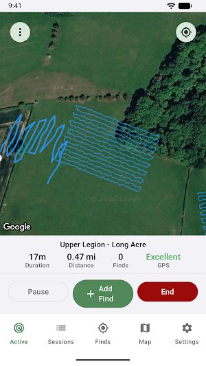
Tap a button to start and My Finds records your path. Auto-end after inactivity, pause and resume cleanly when you stop for lunch. Prepare sessions in advance and start them when you arrive, or resume a finished session next time you're on the same ground.
LOG YOUR FINDS
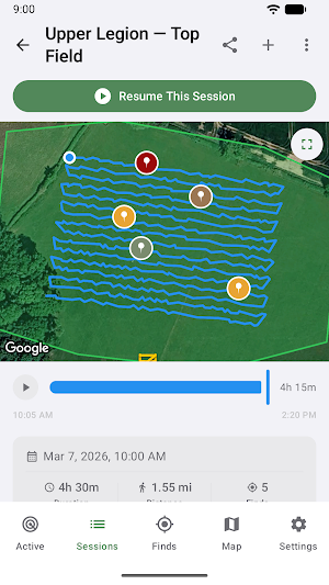
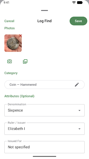
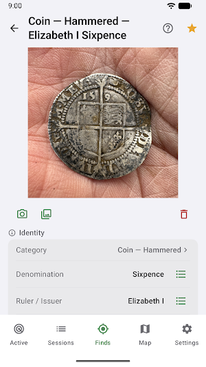
Tap to log a find at its location, and optionally note its category, subcategory, denomination, ruler, type, year, depth, metal type, VDI, and a free-text description. Curated suggestion lists for British and US coinage. Finds can be added later if you miss any while out. Finds show on the map with pins colour-coded by category.
ADD PHOTOS
Take photos in the field, or add them from your gallery. Pinch to zoom on a photo to read hallmarks and legends. Got geotagged photos from before My Finds? Import Finds from Photos turns them into finds and sessions automatically.
RETRACE YOUR STEPS
The Map tab layers previous sessions' paths, so you can see the ground you've covered, and the ground you haven't. Replay any session and watch the path rebuild as the finds appear.
HISTORIC MAPS AND LiDAR
Overlay historic Ordnance Survey maps to research old boundaries, trackways, and lost buildings, or switch on the UK public rights-of-way layer. The LiDAR Terrain overlay reveals ridge and furrow, and other faint earthworks that satellite imagery can't show (England and much of Wales).
PERMISSIONS AND PROTECTED GROUND
Keep a record of landowners: contact details, permission dates, conditions, and a copy of your agreement. Draw your permission boundaries and get a gentle warning as you approach the edge. The Protected Areas overlay shows scheduled monuments in England, Wales and Scotland, plus SSSIs and other protected ground in England, with a warning if you try to start a session on one.
KNOW YOUR SITES
See everything you've found on a permission across every visit: periods, patterns, coverage, and the gaps still to walk.
SHARE A SESSION REPORT
Turn any session into a PDF for the landowner: a map with find pins, a photo and details of each find. Or share a whole site's profile. It's your choice of what info to include.
SEE YOUR PROGRESS
The Insights dashboard turns your finds into charts: totals over time, top sites, metals, periods, and personal records - plus custom filtered queries by date, category, metal, depth, ruler, year and more.
SAFE-KEEPING AND MOVABILITY
Deleted a find by mistake? Restore it within 30 days. Back up everything - finds, sessions, photos, settings - to a single file you can restore on a new phone or merge into an existing collection. Export any session as a GPX file. Moving from another app? My Finds imports finds from FindSpot, GoTerrain, and Digly, or any app that exports GPX or Google Earth KML files.
MOVING FROM iPHONE?
Restore a backup made in My Finds for iOS and your finds, sessions, photos, and settings carry straight across.
UK FEATURES
Every find gets an OS grid reference, and you can link finds to their PAS database records.
REGION-AWARE
Sessions auto-detect the country, with a manual override, and travelling detectorists can add the US and Dutch category sets alongside the UK one.
PRIVACY
No account needed. No ads. No analytics or behavioural tracking. Your finds and sessions live on your device; anonymous crash reports help improve the app.
PRICING
Free to try for your first 20 finds, research map layers included. Pro removes the find limit, adds Custom Queries, and keeps the research layers. Monthly or annual plans, with a 30-day free trial on annual. Either way, your finds stay fully accessible - view, edit and export everything.
What’s new
Version 1.9.1 · Updated October 23, 2026
LiDAR Terrain now covers Wales, and Scotland where surveyed, as well as England. Find a category by typing: a search field in Add Find and on a find's Category row matches categories, subcategories and types. Restoring a backup brings back every category it carries, including custom ones. Directions to Site: driving directions to a session's site in Google Maps or another maps app. Show Previous Finds on the live map. A session ended because you seem to be driving now tells you at once.
Alternatives to My Finds - Metal Detecting
Looking for apps like My Finds - Metal Detecting? Here are 6 similar Android apps on Google Play. The highest rated is Territory Helper (4.7/5), and all 6 are free to download.
-
Walkbox Self-Guided Tours
-
ShipAtlas - Vessel Tracker 4.2
-
ConstructionOnline 3.9
-
Territory Helper 4.7
-
CoinIn – Coin Scan Identifier 4.5
-
OneSoil Scouting: Farming Tool 4.6
| App | Rating | Price | Installs | Last updated | Compare |
|---|---|---|---|---|---|
| My Finds - Metal Detecting | – | Free | 100+ | Oct 23, 2026 | |
| Walkbox Self-Guided Tours | – | Free | 10,000+ | Jun 25, 2026 | Compare |
| ShipAtlas - Vessel Tracker | 4.2 / 5 | Free | 500,000+ | Aug 17, 2026 | Compare |
| ConstructionOnline | 3.9 / 5 | Free | 10,000+ | Oct 23, 2026 | Compare |
| Territory Helper | 4.7 / 5 | Free | 100,000+ | Sep 30, 2026 | Compare |
| CoinIn – Coin Scan Identifier | 4.5 / 5 | Free | 1,000,000+ | Oct 5, 2026 | Compare |
| OneSoil Scouting: Farming Tool | 4.6 / 5 | Free | 500,000+ | Oct 15, 2026 | Compare |