

BayPilot: Boat Navigation
BayPilot Maps & Navigation
Marine navigation, boat GPS, nautical maps, weather and route planning.
- Downloads
- 1.9K+
- on Google Play
- Price
- Free
- No in-app purchases
- Updated
- Oct 15
- 2026 · v1.0.11
Screenshots


About BayPilot: Boat Navigation
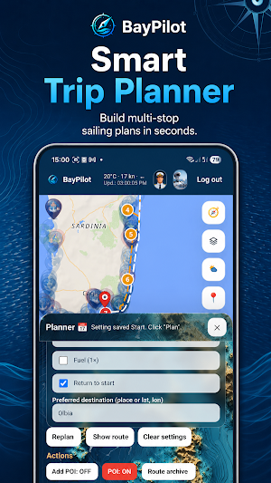
ROUTE PLANNING
• calculate a marine route between two points,
• plan routes with multiple waypoints,
• calculate distance and estimated travel time,
• divide longer voyages into stages,
• save planned routes,
• export routes and tracks as GPX files,
• plan short trips, coastal passages and sailing holidays,
• find marinas, bays, anchorages and other useful places.
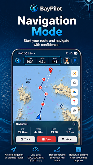
NAVIGATION MODE
After planning a route, tap Start to begin navigation guidance. BayPilot displays your vessel’s current position, progress along the route and essential navigation data:
• COG — actual course over ground,
• SOG — speed over ground,
• BRG — bearing to the next waypoint,
• ETA — estimated time of arrival,
• distance to the next waypoint and destination,
• a COG line showing the vessel’s actual direction of movement.
TRACK AND GPX
The Track feature records the route actually travelled by your boat. After completing your trip, you can open the saved track in the archive, compare it with the planned route and export the data as a GPX file.
EXTERNAL GPS AND NMEA
BayPilot can use position data provided by a compatible chartplotter, NMEA gateway, Signal K system or other onboard equipment.
• connect to a chartplotter or NMEA gateway over Wi-Fi,
• receive GPS position data from onboard equipment,
• work with compatible NMEA and Signal K data sources,
• use an external GPS receiver with the web version on a desktop computer,
• select the most suitable position source for your device and onboard installation.
The availability of individual connection methods depends on the platform, browser, network configuration and equipment being used.
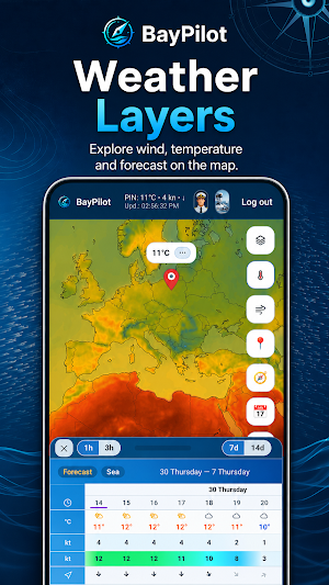
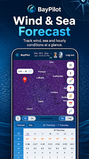
WEATHER FOR SAILORS
Check atmospheric and sea conditions before departure and while planning your voyage:
• wind speed and direction,
• wind gusts,
• air temperature,
• precipitation,
• water temperature in °C,
• sea level,
• wave height in metres,
• wave direction,
• wave period,
• hourly and 3-hour forecasts,
• 7-day and 14-day forecasts.
MAPS AND POIs
Use different map views: Base, Satellite, Nautical and Navigation. Find marinas, anchorages, bays, ports and stopping places to make planning the next stages of your voyage easier.
CAPTAIN AI
Captain AI helps you prepare for your voyage. You can ask about routes, weather, stopping places, marinas, bays, travel stages and general topics related to planning your trip.
WHO IS BAYPILOT FOR?
BayPilot is suitable for short trips on the water, day sailing, sailing holidays and longer coastal passages. The app is designed for planning routes on marine and coastal waters. It is not intended for inland navigation.
IMPORTANT INFORMATION
BayPilot is an app designed to support marine route planning and navigation. It is not a certified professional marine navigation system and does not replace official nautical charts, certified navigation equipment, onboard instruments, sailing directions, current navigational warnings or good seamanship.
Routes calculated by the app are intended for planning and guidance purposes only. Before departure, always check official nautical charts, local regulations, water depths, hazards, weather conditions, warnings and the current situation in the area.
Navigation mode and the Track feature are intended to support navigation along a planned route. The user remains responsible at all times for the safe operation of the vessel, maintaining a proper lookout and making decisions on the water.
What’s new
Version 1.0.11 · Updated October 15, 2026
Version 1.0.11 - Resume anchor alarms and use automatic phone compass bearings. - Improved GPS updates, distance and bearing to the destination, and map follow. - Automatically resume interrupted offline map downloads. - Photo and PDF attachments and an improved Captain AI chat. - Add photos to new POIs and browse the improved gallery. - Fixes for stopping alarms and GPS loss notifications.
Alternatives to BayPilot: Boat Navigation
Looking for apps like BayPilot: Boat Navigation? Here are 6 similar Android apps on Google Play. The highest rated is swisstopo (4.6/5), and 5 of the 6 are free to download.
-
Holland America Line Navigator 2.4
-
Carp Pilot Pro
-
Hello Aurora: Northern Lights 3.8
-
Tripomatic Planner & Maps 4.2
-
FarOut 4.5
-
swisstopo 4.6
| App | Rating | Price | Installs | Last updated | Compare |
|---|---|---|---|---|---|
| BayPilot: Boat Navigation | – | Free | 1,000+ | Oct 15, 2026 | |
| Holland America Line Navigator | 2.4 / 5 | Free | 500,000+ | – | Compare |
| Carp Pilot Pro | – | 6.49 USD | 1,000+ | – | Compare |
| Hello Aurora: Northern Lights | 3.8 / 5 | Free | 100,000+ | Oct 23, 2026 | Compare |
| Tripomatic Planner & Maps | 4.2 / 5 | Free | 1,000,000+ | Sep 21, 2026 | Compare |
| FarOut | 4.5 / 5 | Free | 100,000+ | – | Compare |
| swisstopo | 4.6 / 5 | Free | 1,000,000+ | Aug 26, 2026 | Compare |
Similar apps on Google Play
- Holland America Line Navigator
- Carp Pilot Pro
- Hello Aurora: Northern Lights
- Tripomatic Planner & Maps
- FarOut
- swisstopo
- COLREG 72: Safety at Sea
- Windfinder: Wind & Weather map
- Wialon Local
- Nautide: Tides, Wind, Waves +
- Aqua Map Boating
- VesselFinder
- Orca: Boat GPS, Charts, Routes
- onWater Fish - Fishing Spots
- MarineTraffic - Ship Tracking
- Navionics® Boating
- SeaPeople: Boat Tracker
- Hikingbook: Hike, Bike & Run
- ShipAtlas - Vessel Tracker