

XYESLA Navigator
Puchkov Oleksandr Maps & Navigation
Navigator for Tesla browser with speed cameras, EV chargers & live traffic
- Downloads
- 406+
- on Google Play
- Price
- Free
- No in-app purchases
- Updated
- Aug 14
- 2026 · v1.9.3
Screenshots


About XYESLA Navigator
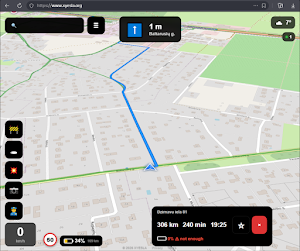
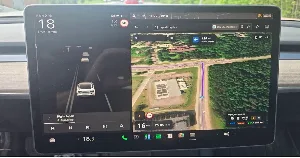
XYESLA Navigator — a web-based navigator designed specifically for the Tesla in-car browser. No app installation needed — just open www.xyesla.org in your Tesla browser and bookmark it. Works on any Tesla model with a browser (Model 3, Y, S, X).
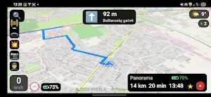
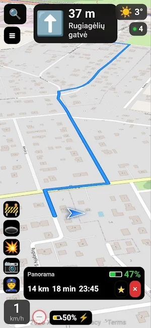
Real-time navigation with traffic-aware routing, speed camera alerts, EV charger locations, hazard warnings from other drivers, and Tesla battery integration — all in a clean, dark-themed interface optimized for driving.
KEY FEATURES
🚦 Traffic-Aware Routing
Routes calculated using TomTom Routing API with live traffic data. The confirmation panel shows total time, traffic delay, and accurate ETA. Automatic fallback to OSRM if TomTom is unavailable.
🔄 Smart Rerouting
Continuously monitors your position. If you deviate more than 70 meters for 4 seconds, a reroute banner appears with a 5-second countdown. New routes are recalculated with live traffic.
🔗 3-Letter Share Codes
Every destination gets a unique 3-letter code (e.g. "K7M"). Set a destination on your phone, get a code, type those 3 letters in the Tesla browser — destination loads instantly.
🔍 Smart Search & Link Parsing
The search box accepts:
• Text search (TomTom with GPS bias)
• Google Maps links (maps.app.goo.gl, google.com/maps)
• Waze share links
• Yandex Maps, 2GIS, Apple Maps, OSM links
• Coordinates ("55.7558, 37.6173")
• 3-letter codes
📷 Speed Camera Alerts
Speed cameras from OpenStreetMap shown on the map: speed cameras, average speed zones, red light cameras, toll enforcement, ALPR. Red alert banner with distance and speed limit when approaching.
⚡ EV Charging Stations (50+ kW)
Only fast chargers shown — DC Fast (CCS/CHAdeMO) and Tesla Superchargers. Data merged from OpenStreetMap and OpenChargeMap. Live details: connector types, power rating, availability, pricing.
⚠️ Community Hazard Reports
Long-press the map to report hazards: police, crash, pothole, road works, camera. Voting system to confirm or dismiss. Reports auto-expire by type.
🔋 Tesla Battery Integration
Connects to the Tesla Fleet API via OAuth 2.0 to show real-time battery level, estimated range, charging status, and battery percentage at arrival. Credentials never stored — only an encrypted refresh token on the server. Disconnect anytime.
🧭 Turn-by-Turn Navigation
Full turn-by-turn guidance: upcoming turn direction, distance to turn, street name, lane guidance. Map rotates in heading-up mode with 3D perspective. Large HUD speed display with speed limit sign.
🌍 Other Features
• Multiple map styles: Satellite, Dark, Light, Topo, CartoDB, Google Hybrid
• GPS smoothing with Kalman filter
• Weather overlay
• Favorites & trip history
• Live online counter
• Privacy-first: no accounts, no tracking, no ads
• Works offline after initial load
• Optimized for Tesla's Chromium browser
WHY XYESLA?
Tesla's built-in navigation is good for basic routing and Supercharger stops, but lacks speed camera warnings, community hazard reports, and quick destination sharing. XYESLA combines modern driver-assist features — running directly in the Tesla browser. No phone, no extra hardware, no installation.
Just bookmark www.xyesla.org and drive.
Real-time navigation with traffic-aware routing, speed camera alerts, EV charger locations, hazard warnings from other drivers, and Tesla battery integration — all in a clean, dark-themed interface optimized for driving.
KEY FEATURES
🚦 Traffic-Aware Routing
Routes calculated using TomTom Routing API with live traffic data. The confirmation panel shows total time, traffic delay, and accurate ETA. Automatic fallback to OSRM if TomTom is unavailable.
🔄 Smart Rerouting
Continuously monitors your position. If you deviate more than 70 meters for 4 seconds, a reroute banner appears with a 5-second countdown. New routes are recalculated with live traffic.
🔗 3-Letter Share Codes
Every destination gets a unique 3-letter code (e.g. "K7M"). Set a destination on your phone, get a code, type those 3 letters in the Tesla browser — destination loads instantly.
🔍 Smart Search & Link Parsing
The search box accepts:
• Text search (TomTom with GPS bias)
• Google Maps links (maps.app.goo.gl, google.com/maps)
• Waze share links
• Yandex Maps, 2GIS, Apple Maps, OSM links
• Coordinates ("55.7558, 37.6173")
• 3-letter codes
📷 Speed Camera Alerts
Speed cameras from OpenStreetMap shown on the map: speed cameras, average speed zones, red light cameras, toll enforcement, ALPR. Red alert banner with distance and speed limit when approaching.
⚡ EV Charging Stations (50+ kW)
Only fast chargers shown — DC Fast (CCS/CHAdeMO) and Tesla Superchargers. Data merged from OpenStreetMap and OpenChargeMap. Live details: connector types, power rating, availability, pricing.
⚠️ Community Hazard Reports
Long-press the map to report hazards: police, crash, pothole, road works, camera. Voting system to confirm or dismiss. Reports auto-expire by type.
🔋 Tesla Battery Integration
Connects to the Tesla Fleet API via OAuth 2.0 to show real-time battery level, estimated range, charging status, and battery percentage at arrival. Credentials never stored — only an encrypted refresh token on the server. Disconnect anytime.
🧭 Turn-by-Turn Navigation
Full turn-by-turn guidance: upcoming turn direction, distance to turn, street name, lane guidance. Map rotates in heading-up mode with 3D perspective. Large HUD speed display with speed limit sign.
🌍 Other Features
• Multiple map styles: Satellite, Dark, Light, Topo, CartoDB, Google Hybrid
• GPS smoothing with Kalman filter
• Weather overlay
• Favorites & trip history
• Live online counter
• Privacy-first: no accounts, no tracking, no ads
• Works offline after initial load
• Optimized for Tesla's Chromium browser
WHY XYESLA?
Tesla's built-in navigation is good for basic routing and Supercharger stops, but lacks speed camera warnings, community hazard reports, and quick destination sharing. XYESLA combines modern driver-assist features — running directly in the Tesla browser. No phone, no extra hardware, no installation.
Just bookmark www.xyesla.org and drive.
Alternatives to XYESLA Navigator
Looking for apps like XYESLA Navigator? Here are 6 similar Android apps on Google Play. The highest rated is RateHawk for Professionals (4.9/5), and all 6 are free to download.
-
RateHawk for Professionals 4.9
-
Detecht - Motorcycle App & GPS 4.1
-
TomTom GO Expert: Truck GPS 3.6
-
Mapy.com: Offline Outdoor Maps 4.1
-
HERE WeGo: Maps & Navigation 3.3
-
StarLine 2 4.3
| App | Rating | Price | Installs | Last updated | Compare |
|---|---|---|---|---|---|
| XYESLA Navigator | – | Free | 100+ | Aug 14, 2026 | |
| RateHawk for Professionals | 4.9 / 5 | Free | 50,000+ | Oct 13, 2026 | Compare |
| Detecht - Motorcycle App & GPS | 4.1 / 5 | Free | 500,000+ | Oct 8, 2026 | Compare |
| TomTom GO Expert: Truck GPS | 3.6 / 5 | Free | 10,000,000+ | Oct 12, 2026 | Compare |
| Mapy.com: Offline Outdoor Maps | 4.1 / 5 | Free | 10,000,000+ | Oct 18, 2026 | Compare |
| HERE WeGo: Maps & Navigation | 3.3 / 5 | Free | 10,000,000+ | Sep 21, 2026 | Compare |
| StarLine 2 | 4.3 / 5 | Free | 1,000,000+ | – | Compare |
Compare XYESLA Navigator with the top alternatives: ratings, updates, ASO score and keyword gaps →
Similar apps on Google Play
- RateHawk for Professionals
- Detecht - Motorcycle App & GPS
- TomTom GO Expert: Truck GPS
- Mapy.com: Offline Outdoor Maps
- HERE WeGo: Maps & Navigation
- StarLine 2
- Magic Earth Navigation & Maps
- TwoNav 6: Routes and Maps
- WhatsGPS
- Froling Connect
- FarOut
- Sygic GPS Truck & Caravan
- Multi-Stop Route Planner
- Mileage Tracker by Driversnote
- TomTom - Maps & Traffic
- Vy