

Offline Maps: Emergency Finder
qaqee Tecnologia da informacao Navigation iPhoneiPadiPod touch
Offline Maps: Emergency Finder is a free Navigation app for iPhone and iPad by qaqee Tecnologia da informacao. Requires iOS 17.0. Updated October 2, 2026.
- Price
- Free
- on the App Store
- Size
- 384 MB
- Age 4+
- Updated
- Oct 2
- 2026 · v1.1.1
Screenshots


About Offline Maps: Emergency Finder
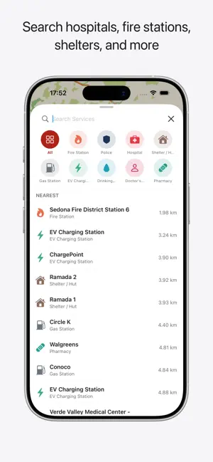
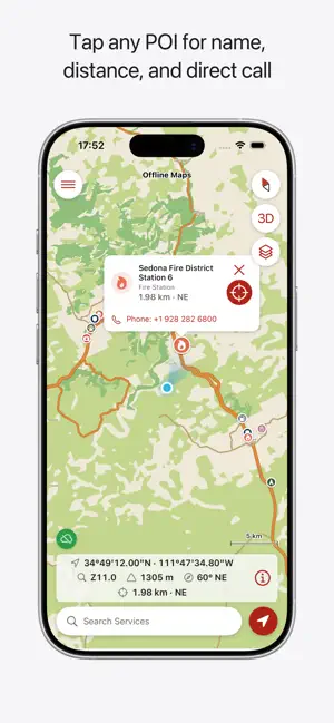
Most offline maps show you where you are. This one shows you where the nearest hospital, pharmacy, police station, fire station, ambulance station, and others are — 4.1 million emergency facilities worldwide, stored on your phone, working with no signal, no data plan, and no cell towers. BUILT DIFFERENTLY, NOT JUST OFFLINE Plenty of apps cache a map for when you lose signal. This one goes further: a bundled world basemap works the moment you install it, regional maps download for offline use, and a 4.1-million-point emergency-services database — hospitals, pharmacies, police, fire, ambulance stations, and more — is searchable entirely on-device, sorted by real distance from your GPS position. No other offline map combines a real basemap and a searchable emergency-services layer in one app that needs no connection at all once it's loaded. DOWNLOAD BEFORE YOU GO, USE ANYWHERE Download the map for your region and the emergency services database before you leave. Once you're offline, everything still works — the map, your GPS position, the compass, and the full searchable database of emergency services. WORKS ONLINE AND OFFLINE Use it like any map app when you have a connection. When you don't — lost signal, no data plan, a disaster knocking out networks — it keeps working. A world basemap ships inside the app itself, so country and regional views work the moment you install it, online or off. Add offline maps for specific countries or regions for the detail you need on the ground. A map badge always tells you whether what you're looking at is fully local, loading online, or needs a download — so you're never guessing about what will work when the signal drops. FIND EMERGENCY SERVICES OFFLINE • Hospitals, police stations, fire stations, pharmacies, and ambulance stations • Plus a broader "other" category covering every other mapped emergency-relevant amenity nearby • Search by name, filter by category, sorted by distance from where you are • Tap any location for distance, bearing, address, opening hours, phone, and wheelchair access • The nearest facility of each critical category always shows on the map • Works entirely offline once the database is downloaded PRECISION GPS AND NAVIGATION • Live position with accuracy ring and heading beam • 3D follow mode that tracks your compass heading, with auto-recenter • Always-visible readout: coordinates, scale bar, GPS fix age, distance and direction to your target • Coordinate formats: Degrees/Minutes/Seconds, Decimal Degrees, and MGRS • Kilometers or miles, matched to your device or set by hand • Long-press anywhere to drop a pin; tap any facility to set it as your target and track live distance and direction as you move BUILT FOR THE OUTDOORS Three map styles — Standard, Outdoors, and Dark. The Outdoors palette renders real terrain: forests, scrub, grassland, sand, bare rock, scree, wetlands, glaciers, and snow. USE IT FOR — Hiking and trail navigation when the trail runs out of signal — Getting turned around in the backcountry and needing to find your bearings and the nearest help — Roadside breakdowns and car trouble on a rural or unfamiliar route — Backpacking, camping, and overlanding beyond cell range — International travel without a local SIM or a data plan — Ski touring and mountain terrain — Sailing and coastal cruising — Accidents and injuries where every extra minute finding help matters — Disaster preparedness, for when networks are down — Remote work on sites away from connectivity More at https://apps.qaqee.com
What’s new
Version 1.1.1 · Updated October 2, 2026
- New languages added - Bug fixes - Minor general improvements
App privacy
The developer, qaqee Tecnologia da informacao, reported these privacy practices to Apple.
Data Not Linked to You
The following data, which may be collected but is not linked to your identity, may be used for the following purposes:
- Identifiers: Device ID
- Usage Data: Product Interaction
- Diagnostics: Crash Data, Performance Data
- Location: Precise Location
Used for: Analytics, App Functionality
Alternatives to Offline Maps: Emergency Finder
Looking for apps like Offline Maps: Emergency Finder? Here are 6 similar apps on the App Store.


| App | Rating | Price | Last updated | Compare |
|---|---|---|---|---|
| Offline Maps: Emergency Finder | – | Free | October 2, 2026 | |
| Roamap - Emergency Safety | – | Free | Jul 8, 2026 | Compare |
| ParkiTT | – | Free | Jul 16, 2026 | Compare |
| Safe Rio | – | Free | Oct 21, 2026 | Compare |
| Shahin GPS | – | Free | Oct 22, 2026 | Compare |
| TOPSII Driver | – | Free | Oct 19, 2026 | Compare |
| Conect Rastreadores | – | Free | Mar 3, 2025 | Compare |