

Avyline - Backcountry Ski Map
国刚 赵 Navigation iPhoneiPadiPod touch
Avyline - Backcountry Ski Map is a free Navigation app for iPhone and iPad by 国刚 赵. Rated 5.0/5 from 1 ratings. Requires iOS 16.0. Updated October 15, 2026.
- Rating
- 5.0
- 1 ratings
- Price
- Free
- on the App Store
- Size
- 13 MB
- Age 4+
- Updated
- Oct 15
- 2026 · v2.1.0
Screenshots



About Avyline - Backcountry Ski Map
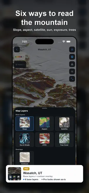
Avyline is an offline 3D terrain planner for backcountry skiing. Draw your line, see how steep it gets and how much of it sits in avalanche terrain, compare alternatives and export the plan — all with zero cell signal. The angle under your feet, the steep ground ahead and the official avalanche forecast, on one map. PLAN YOUR TOUR • Draw a route and read its elevation profile, avalanche-exposure percentage and estimated time (a range, never a single number). • Corridor analysis breaks the line down: continuous steep sections, overhead steep terrain, terrain traps, aspect rose and elevation-band distribution — terrain facts only, never a safe/unsafe verdict. • Compare two routes side by side on the same facts. Add backup routes, typed waypoints (observe / decide / turn around) and No-Go zones. • Simulate sun and shade by date; export the plan as a PDF or image card with map attribution and a timestamp footer. • Reuse a plan as a template for a new date (forecast and sun reload). Import routes from other tools — GPX free, plus KML, KMZ and FIT with Pro. • Browse curated classic lines and community ski tours (free where regions have them); load one into the planner with Pro. FREE SAFETY, ALWAYS ON • SlopeGuard reads the slope under your feet; turn alerts on (off by default) for a one-time warning when you enter terrain steeper than your threshold. • Look-ahead radar scans the terrain in your direction of travel and flags steep slopes before you reach them. • Avalanche hazard highlighting paints dangerous terrain onto the 3D map, driven by the official forecast's elevation-band rating when one is available. • Slope warnings, look-ahead radar, hazard overlay, the slope heatmap, terrain exposure and official forecasts are free forever — never paywalled. OFFICIAL FORECASTS, SHOWN HONESTLY • Avalanche danger ratings from official public warning services (avalanche.org member centers, SLF and EAWS partners), broken out by elevation band — in the regions those services cover. • Ratings expire automatically at their validity end. "No rating" is its own state — never shown as "low danger." • Every forecast shows its source and publication time. TRUE OFFLINE 3D • Each region (~5–40 MB, sized to area and resolution) packs high-resolution terrain, aerial/satellite imagery, contours, hillshade and place names — downloaded once, usable forever without signal. • Slope, aspect, contours and shaded relief rendered at 60 fps by an in-house engine. • The Terrain Exposure layer classifies avalanche terrain into three in-house grades (1–3), computed on-device and honestly labelled as not an official rating. • Search peaks, passes and huts; save your own waypoints. FREE VS PRO • Free: one downloaded region, the entire safety base above, and a taste of planning — draw one route with its profile. Safety is never paywalled. • Pro (a single annual subscription, $4.99/year): the full planning toolkit — corridor analysis, A/B route comparison, backup routes with typed waypoints and No-Go zones, sun & shade simulation, plan-card export (PDF/image), templates, curated classic routes in the planner, forecast alerts, KML/KMZ/FIT import, tree cover and unlimited plans — plus the aspect, contour and satellite layers and every region worldwide, fully offline. IMPORTANT Avyline is a decision-support tool, not a substitute for formal avalanche training, a current official forecast, beacon/shovel/probe or your own judgment. Corridor analysis and profiles report terrain facts only — they never assess snow stability or issue a safe/unsafe verdict. Terrain angles come from digital elevation data with finite accuracy, which the app discloses openly. Travel in avalanche terrain at your own risk. Terms of Use: https://www.apple.com/legal/internet-services/itunes/dev/stdeula/
What’s new
Version 2.1.0 · Updated October 15, 2026
Bug fixes and stability improvements.
App privacy
The developer, 国刚 赵, reported these privacy practices to Apple.
Data Not Collected
The developer does not collect any data from this app.
Alternatives to Avyline - Backcountry Ski Map
Looking for apps like Avyline - Backcountry Ski Map? Here are 6 similar apps on the App Store. The highest rated is 10digit - MGRS Land Nav & TAK (5.0/5), and all 6 are free to download.
-
 Balise - Topo Maps & GPX
-
 Route3D 3.0
2.5
-
 Bolt Speed: speedometer
4.3
-
 10digit - MGRS Land Nav & TAK
5.0
-
 MGRS Offline Map Satellite
5.0
-
 Scenic Map Grand Canyon
5.0
| App | Rating | Price | Last updated | Compare |
|---|---|---|---|---|
| Avyline - Backcountry Ski Map | 5.0 / 5 (1 rating) | Free | October 15, 2026 | |
| Balise - Topo Maps & GPX | – | Free | Oct 13, 2026 | Compare |
| Route3D 3.0 | 2.5 / 5 (4) | Free | Jun 29, 2026 | Compare |
| Bolt Speed: speedometer | 4.3 / 5 (9) | Free | Aug 15, 2026 | Compare |
| 10digit - MGRS Land Nav & TAK | 5.0 / 5 (5) | Free | Oct 18, 2026 | Compare |
| MGRS Offline Map Satellite | 5.0 / 5 (1) | Free | May 28, 2026 | Compare |
| Scenic Map Grand Canyon | 5.0 / 5 (2) | Free | Jan 19, 2024 | Compare |