

Balise - Topo Maps & GPX
Magenta Creations Navigation iPhoneiPadiPod touchMac
Balise - Topo Maps & GPX is a free Navigation app for iPhone and iPad by Magenta Creations. Requires iOS 26.0. Updated October 13, 2026.
- Price
- Free
- on the App Store
- Size
- 10 MB
- Age 4+
- Updated
- Oct 13
- 2026 · v1.6.1
Screenshots



About Balise - Topo Maps & GPX
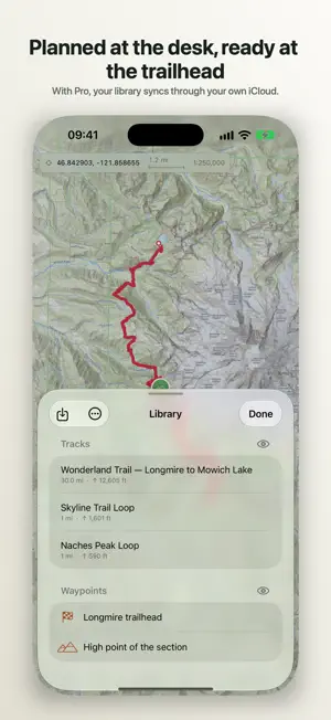
The official national surveys on iPhone and iPad: USGS, the IGN map of France, swisstopo and IGN España, with your own routes drawn over them. Balise is one app for Mac, iPhone and iPad. Plan on the large screen, and with Pro your library is on the phone at the trailhead, synced through your own iCloud. One Pro purchase covers them all. In English and French. UNITED STATES: FIVE USGS LAYERS US Topo, Imagery Topo, NAIP, 3DEP shaded relief and NHD hydrography, public domain. FRANCE: NINE IGN ENTRIES • Plan IGN — the reference map, down to 1:5,000 • Aerial photography — BD ORTHO®, 20 cm • Aerial photography through time — seven editions on one slider: a path clear in 1965 and under canopy by 2023 is a path no longer there • Slope shading — above 30°, from RGE ALTI® • Forest cover — BD Forêt® v2, dominant species • Place names — BD TOPO® toponyms, with no basemap under them • Forest rescue points — the posts French firefighters ask for • Historic sheets — état-major (1820-1866) and SCAN 50 (1950) SWITZERLAND AND SPAIN Five swisstopo layers: the Landeskarte to 1:10,000, a grey edition for reading overlays against, SWISSIMAGE at 10 cm, swissALTI3D relief and the surveyed hiking network. Two from IGN España: the Mapa Topográfico Nacional and PNOA orthophotography. Borders are real ones: a country's maps are offered as soon as its ground is on screen. A STACK YOU DRIVE Layers stack over Apple's basemap, satellite or hybrid, or over a blank floor that makes slope shading readable alone. Every layer has its own opacity, and hiding one, or the basemap, keeps its place. Tap 3D and the real relief rises under them all. WHERE YOU ARE The locate button steps through off, follow, and follow with heading, so the map turns to face the way you are walking. Pan and following stops. Your position is drawn and nothing more, never recorded or sent. Long-press the map to measure a distance or an area. YOUR TRACKS • Open GPX from Files, a share sheet or a mail attachment, several at once • An elevation profile you scrub with a finger, the point marked on the map • Distance, ascent, descent, elevation range and duration, metric or imperial • Export GPX 1.1 to Files, crediting every visible source • Eight track colours, kept on import and export BALISE PRO, A ONE-TIME UNLOCK • Offline maps: choose an area and its layers, and those tiles stay on disk until you delete them • The cadastre: parcel outlines, the parcel you point at measured, every visible parcel labelled • Draw a route with your finger, each leg snapped to the real path network, with a toggle for a straight segment • A walking time from Tobler's hiking function, integrated over the climb, not a flat average speed • Historic monuments: 44,310 protected buildings, drawn with no network • Petites Cités de Caractère: 207 labelled small towns • Huts, cabins and water points from refuges.info, including those marked closed Snapping and the overlays are French; elsewhere Pro unlocks drawing without snapping. Not a subscription: buy it once. OPEN DATA, PROPERLY CREDITED France from IGN's Géoplateforme under Licence Ouverte / Etalab 2.0, Switzerland from swisstopo under FSDI terms, Spain from IGN España under CC BY 4.0, the US public domain from USGS. No key, no account with a mapping company. PRIVACY No account, no sign-up, no telemetry. Balise talks to the mapping agencies whose layers are on screen, Apple for the basemap and for search outside France, and refuges.info if you turn it on. Nothing else. Your library stays on your devices and, with sync on, in your private iCloud. WHAT BALISE DOES NOT DO No turn-by-turn navigation and no voice guidance. No route sharing. Requires iOS or iPadOS 26. Balise for Mac is free from this same listing. Balise is a planning tool, not safety equipment. In the mountains, carry a paper map and check conditions before setting out.
What’s new
Version 1.6.1 · Updated October 13, 2026
Fixes across the app, starting with offline maps. • Offline downloads follow the High-resolution cartography setting: turned off, a region takes a quarter of the data • An offline region deleted while downloading stays deleted, and its space shows as free at once • After a launch with no network, Pro can be bought without relaunching • Cancelling Restore Purchases no longer shows a warning • Undoing a measurement point's drag redraws the line • A new search is no longer overridden by the previous one • VoiceOver steps through the whole elevation profile of a long track
App privacy
The developer, Magenta Creations, reported these privacy practices to Apple.
Data Not Collected
The developer does not collect any data from this app.
Alternatives to Balise - Topo Maps & GPX
Looking for apps like Balise - Topo Maps & GPX? Here are 6 similar apps on the App Store. The highest rated is Skypaper - Photos as postcards (5.0/5), and all 6 are free to download.
-
 MeshTrail
4.7
-
 iLende: Hiking Map
-
 Mountain Goat Tours
-
 Skypaper - Photos as postcards
5.0
-
 Motonest Motorcycle Places Map
4.0
-
 Bolt Speed: speedometer
4.3
| App | Rating | Price | Last updated | Compare |
|---|---|---|---|---|
| Balise - Topo Maps & GPX | – | Free | October 13, 2026 | |
| MeshTrail | 4.7 / 5 (3) | Free | Aug 15, 2026 | Compare |
| iLende: Hiking Map | – | Free | Oct 19, 2026 | Compare |
| Mountain Goat Tours | – | Free | Mar 24, 2026 | Compare |
| Skypaper - Photos as postcards | 5.0 / 5 (1) | Free | Jun 8, 2026 | Compare |
| Motonest Motorcycle Places Map | 4.0 / 5 (1) | Free | Oct 18, 2026 | Compare |
| Bolt Speed: speedometer | 4.3 / 5 (9) | Free | Aug 15, 2026 | Compare |