

MeshTrail
SHANE FRANCIS CLARK Navigation iPhoneiPadiPod touch
MeshTrail is a free Navigation app for iPhone and iPad by SHANE FRANCIS CLARK. Rated 4.7/5 from 3 ratings. Requires iOS 17.0. Updated August 15, 2026.
- Rating
- 4.7
- 3 ratings
- Price
- Free
- on the App Store
- Size
- 2.0 GB
- Age 4+
- Updated
- Aug 15
- 2026 · v1.6.0
Screenshots


About MeshTrail
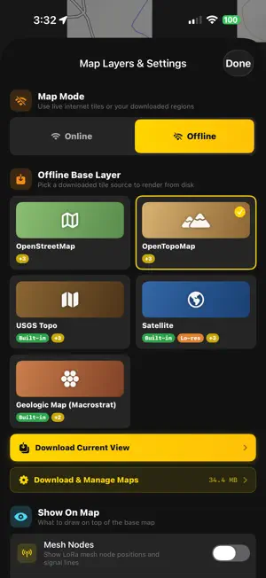
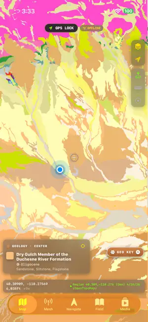
MeshTrail — Off-Grid Navigation & LoRa Mesh Communication Navigate the backcountry with confidence. MeshTrail combines GPS navigation, offline maps, LoRa mesh networking, and comprehensive field guides in one powerful app designed for hikers, hunters, anglers, and outdoor enthusiasts. Works 100% offline. NAVIGATION - Full offline map support with downloadable tile regions (Standard, Satellite, Hybrid, Topo) - GPS track recording with elevation profiles and pace tracking - Compass navigation with bearing-to-target guidance - Route planning with stops, difficulty ratings, and Naismith time estimates - Route following: step-by-step guidance with auto-advance, off-route alerts, and finish ETA - Tap anywhere on the map to drop a waypoint - AR peak identification using your camera HUNTING & PUBLIC LANDS - Public lands overlays: BLM and USFS boundaries - Colorado wildlife overlay: State Wildlife Areas, Walk-In Access, and Game Management Unit (GMU) boundaries — where hunters tag in - Tap any point in Colorado to see its GMU, county, public-access property, and elk/deer units - Comprehensive hunting guides with Colorado regulations and GMU references - Fishing guides with species, techniques, lures, and location tips - Step-by-step field dressing and game processing instructions - Solunar activity forecaster for hunting and fishing MESH NETWORKING - Connect to Meshtastic and MeshCore LoRa radios via Bluetooth - Send and receive text messages completely off-grid - See mesh node positions on the map in real-time - Monitor battery levels, signal strength, and telemetry data - Automatic position broadcasting to share your location with your group WILDLIFE FIELD GUIDES - 130+ North American species with high-quality photos - Detailed track and scat identification diagrams for field use - 100+ plants, trees, bushes, flowers, and mushrooms — browse by type, with edibility ratings, foraging tips, and dangerous-lookalike warnings SURVIVAL TOOLS - First aid protocols for 30+ emergency scenarios - SOS beacon with visual Morse code flashlight signal - Barometric weather monitoring with pressure trend analysis - Real-time river and stream gauge data from USGS NWIS - Radio frequency reference (Emergency, GMRS, Ham, CB, FRS) - Wind chill calculator with hypothermia risk assessment - Altitude sickness risk calculator - Avalanche danger assessment tool - Triangulation position fixing with compass bearings - Geologic basemap with rock-unit lookup powered by Macrostrat - Unit converter for distance, altitude, temperature, weight, and pressure MEDIA CENTER - Offline media player supporting audio, video, PDF, and ebooks - Wildlife sound library with 28 species calls - Bundled field reference library with classic outdoor and survival texts - Retro arcade games: Neon Snake, Neon Tetris, and a full isometric combat racer - Virtual pet companion with achievements and XP system Everything for safety and navigation — maps, mesh, SOS, weather, and the full field guide — is free. MeshTrail is free to download with one optional $2.99 Premium unlock that adds extra color themes, the AR star chart, arcade games, and the virtual pet. All data stays on your device.
What’s new
Version 1.6.0 · Updated August 15, 2026
OFFLINE MAPS — North Park, pre-installed. • Satellite imagery at full zoom over the North Park basin — Walden, Rand, Gould, Cameron Pass and the Never Summer range — ready the moment you install, with no download and no signal. • Topographic, geologic, BLM public-land and Forest Service layers pre-installed across the same area, reaching out to Steamboat, the Poudre canyon and Laramie. • The app is a fraction of its former download size despite the added map detail, so it installs faster and works over cellular. BLUETOOTH & MESH — rebuilt. • See every radio. Radios already connected to your iPhone were invisible before; they now appear in an "Other radios" list on the connection card, so you can switch without disconnecting first. • Pairing that works. The PIN screen no longer disappears while you're reading the code off your radio, and cancelling it no longer triggers a cascade of repeat prompts. • Messages send. Retrying a failed message and composing a direct message both used a path with no retry and no readiness check, so they could fail the instant you tapped send. Every send path now waits for the link and retries properly. • Honest status. The connection card tells you when a radio is connected but silent, instead of showing a healthy green card. Plus: node lists show real last-heard times, direct-message encryption badges tell the truth, and low-battery alerts fire on connect.
App privacy
The developer, SHANE FRANCIS CLARK, reported these privacy practices to Apple.
Data Not Collected
The developer does not collect any data from this app.
Alternatives to MeshTrail
Looking for apps like MeshTrail? Here are 6 similar apps on the App Store. The highest rated is APRSSwift (5.0/5), and all 6 are free to download.


| App | Rating | Price | Last updated | Compare |
|---|---|---|---|---|
| MeshTrail | 4.7 / 5 (3 ratings) | Free | August 15, 2026 | |
| iLende: Hiking Map | – | Free | Oct 19, 2026 | Compare |
| Route3D 3.0 | 2.5 / 5 (4) | Free | Jun 29, 2026 | Compare |
| MeshWave | 3.3 / 5 (8) | Free | Jul 13, 2026 | Compare |
| SGS MinFinder | – | Free | Sep 28, 2026 | Compare |
| APRSSwift | 5.0 / 5 (2) | Free | Oct 1, 2026 | Compare |
| Geo Data Collector | – | Free | Aug 24, 2026 | Compare |
Compare MeshTrail with the top alternatives: ratings, updates, ASO score and keyword gaps →