

Geo Data Collector
Tech Maven GeoSpatial LLC Navigation iPhoneiPadiPod touch
Geo Data Collector is a free Navigation app for iPhone and iPad by Tech Maven GeoSpatial LLC. Requires iOS 17.0. Updated August 24, 2026.
- Price
- Free
- on the App Store
- Size
- 116 MB
- Age 4+
- Updated
- Aug 24
- 2026 · v1.4.1
Screenshots


About Geo Data Collector
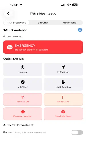
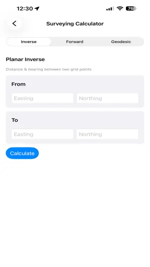
Geo Data Collector turns your iPhone or iPad into an offline-first field GIS for mapping, asset inspection, structured data collection, surveying calculations, and construction layout job preparation. FIELD DATA COLLECTION • Capture points, lines, and polygons with attributes and photos. • Build forms in the app or import shareable JSON form designs. • Mark fields as required or optional and use text, number, date, checkbox, radio-button, and selection controls. • Review, search, edit, delete, and return to collected features on the map. EXTERNAL GNSS, RTK & NTRIP • Connect a compatible Bluetooth GNSS receiver that outputs NMEA 0183. • Stream validated RTCM 3 corrections from NTRIP v1/v2 RTN or CORS casters to the external rover. • Monitor fix type, receiver-reported accuracy, DOP, satellite count, signal quality, correction age, and data freshness. • Apply configurable quality gates, stable-fix checks, and ECEF/ENU point averaging before capture. • Preserve observations, occupations, antenna information, quality decisions, and available coordinate-operation provenance in versioned archives. The external receiver computes the RTK position solution. Achievable accuracy depends on the receiver, antenna, environment, correction service, configuration, and field procedures. SURVEYING & GEODESY TOOLS • Planar COGO inverse and forward calculations. • WGS84 geodesic inverse and direct calculations. • Polygon area, perimeter, orientation, and centroid. • Slope distance, grade, inclination, and elevation difference. • Stakeout deltas, Bowditch traverse adjustment, and angular-closure diagnostics. • WGS84 ECEF/UTM operations, explicit control localization, and auditable geodesy reports. CONSTRUCTION LAYOUT PREPARATION • Create and manage layout jobs and design targets. • Import targets from supported GeoJSON and CSV/ASCII point files. • Configure metric, international-foot, or US-survey-foot units and horizontal/vertical tolerances. • Build a 2D site localization from control pairs and review residual diagnostics. • Export as-built CSV, stake-report JSON, and Markdown field reports. OFFLINE MAPS & OPEN DATA • Work with GeoPackage, GeoJSON, raster MBTiles, and vector MBTiles. • Use online and offline basemaps, including vector, terrain/topographic, hillshade, satellite, and boundary layers where available. • Browse searchable attribute tables and control layer styling, visibility, opacity, and display order. • Convert supported vector formats, including zipped Shapefile, KML, GPX, CSV, and WKT, into app-ready data. FIELD OPERATIONS • Measure distance and area, record GPS tracks, search OpenStreetMap, save spatial bookmarks, and view coordinates in multiple formats. • Use offline field projects, field editing workflows, and geodesy/control reports. • Share files through supported cloud, FTP, WebDAV, and local Wi-Fi workflows. • Connect TAK Server and Meshtastic workflows for team position and messaging. Core collection and offline mapping do not require a proprietary server-side database. Some capabilities require compatible external hardware, network or correction services, imported data, or an in-app purchase. Geo Data Collector is a field mapping and construction aid. It does not replace a licensed surveyor, legal boundary determination, instrument calibration, or required professional quality-control procedures.
What’s new
Version 1.4.1 · Updated August 24, 2026
• Expanded external GNSS and RTK workflows with Bluetooth NMEA input, NTRIP corrections, RTCM validation, configurable quality gates, and point averaging. • Added surveying calculators for planar COGO, WGS84 geodesics, polygons, slope and grade, stakeout deltas, Bowditch traverses, and angular closure. • Added construction layout job preparation with design targets, tolerances, units, 2D site localization, and field-report exports. • Added stronger GNSS observation and occupation records with quality and coordinate-operation provenance. • Added offline field project, field editing, geodesy, and control workflows.
App privacy
The developer, Tech Maven GeoSpatial LLC, reported these privacy practices to Apple.
Data Not Collected
The developer does not collect any data from this app.
Alternatives to Geo Data Collector
Looking for apps like Geo Data Collector? Here are 6 similar apps on the App Store. The highest rated is Survey360 (5.0/5), and all 6 are free to download.
-
 topoXpress
4.0
topoXpress
4.0
-
 MyGIS
1.0
MyGIS
1.0
-
 Survey360
5.0
Survey360
5.0
-
 Global Mapper Mobile
3.7
Global Mapper Mobile
3.7
-
 Eos Tools Pro
4.6
Eos Tools Pro
4.6
-
 Mapply for Open Street Map
4.1
Mapply for Open Street Map
4.1
| App | Rating | Price | Last updated |
|---|---|---|---|
| Geo Data Collector | – | Free | August 24, 2026 |
| topoXpress | 4.0 / 5 (3) | Free | Mar 19, 2026 |
| MyGIS | 1.0 / 5 (1) | Free | Jan 25, 2024 |
| Survey360 | 5.0 / 5 (1) | Free | Feb 22, 2024 |
| Global Mapper Mobile | 3.7 / 5 (15) | Free | Feb 11, 2026 |
| Eos Tools Pro | 4.6 / 5 (9) | Free | Sep 17, 2026 |
| Mapply for Open Street Map | 4.1 / 5 (51) | Free | May 15, 2024 |