

IGN: Wildland Fire Scanner app
Evgeniya Vorontsova Weather iPhoneiPadiPod touch
IGN: Wildland Fire Scanner app is a free Weather app for iPhone and iPad by Evgeniya Vorontsova. Requires iOS 17.0. Updated September 15, 2026.
- Price
- Free
- on the App Store
- Size
- 14 MB
- Age 4+
- Updated
- Sep 15
- 2026 · v0.3.2
Screenshots
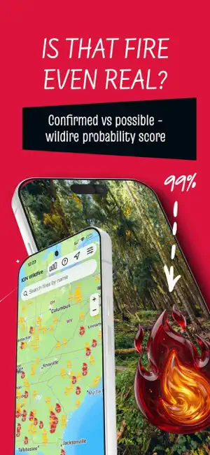

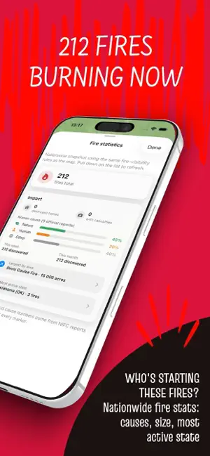
About IGN: Wildland Fire Scanner app
Smoke on the horizon? Fire scanner with a live wildfire map: confirmed vs possible fires, ranked by distance, size, and how fast they're growing. Every wildfire on the map carries a probability score, not a guess. - Confirmed (80%+) - official reports and fresh satellite heat agree. Treat it as real. - Likely (50-79%) - strong satellite evidence, no official confirmation yet. - Possible (25-49%) - some heat detected. Could be small, brand-new, or a false alarm. - Weak signal (below 25%) - a faint or aging trace, hidden by default. That score comes from cross-checking multiple public feeds, the same ones emergency teams watch. NIFC supplies official incident reports and mapped fire boundaries. NOAA GOES weather satellites watch the country around the clock and flag new heat within minutes. NASA VIIRS and MODIS satellites orbit several times a day and can spot a fire the size of a building. The National Weather Service adds Red Flag Warnings for where fire weather turns dangerous. A single satellite hotspot can be a false alarm - a factory roof, a gas flare, sometimes a bonfire. The more independent sources agree, the higher the number climbs. No fire science background required. The probability score does the interpreting for you. Sort the active fire list the way you actually need it: - Most urgent - Nearest to you - Largest by acreage - Most recently reported Tap any fire for the full picture: acres burned, containment percentage, when it was discovered, when NIFC last updated it, and when the last satellite heat was detected. Recent detections break down by source, so you see exactly how many hits came from GOES, MODIS, or VIIRS and how many hours ago. "Near me" filtering runs entirely on your device. Your location never leaves your phone. Get directions to a fire zone, share a fire's details with family, or jump straight to official NIFC and InciWeb links. Coverage isn't limited to one state. Track wildfires across Cal, Oregon, Washington, Colorado, Texas, and all 50 states from a single map. This app is built for awareness, not evacuation decisions. Satellites can miss fires under thick smoke or cloud cover, and official reports can lag behind a fast-moving fire. In an emergency, always follow local authorities and check NIFC or InciWeb for official incident updates. You're driving into a smoky valley and want to know if it's a nearby fire or just haze blowing in. You live near wildland-urban interface and check every red flag warning before a windy weekend. You have family in a fire-prone state and want a faster update than the evening news. You're planning a backcountry trip and need to know what's burning along the route before you leave. A dot on a map means nothing without knowing how sure anyone actually is. https://nikogdanekupluslona-svg.github.io/cawildfire-site/terms.html https://nikogdanekupluslona-svg.github.io/cawildfire-site/privacy.html
What’s new
Version 0.3.2 · Updated September 15, 2026
National wildfire statistics have been updated. Now you know which states are currently at risk. The interface has been polished. The database has been expanded.
App privacy
The developer, Evgeniya Vorontsova, reported these privacy practices to Apple.
Data Not Collected
The developer does not collect any data from this app.
Alternatives to IGN: Wildland Fire Scanner app
Looking for apps like IGN: Wildland Fire Scanner app? Here are 6 similar apps on the App Store. The highest rated is Wildfire Map Tracker (5.0/5), and all 6 are free to download.
-
 FireNear - Wildfire Alerts
-
 FireGuard: Emergency & Safety
-
 Wildfire monitor - Pyriskopos
-
 Wildfire Map Tracker
5.0
-
 Wildfire Tracker—Live Fire Map
4.5
-
 Firespot: Wildfire app
4.7
| App | Rating | Price | Last updated | Compare |
|---|---|---|---|---|
| IGN: Wildland Fire Scanner app | – | Free | September 15, 2026 | |
| FireNear - Wildfire Alerts | – | Free | Aug 27, 2026 | Compare |
| FireGuard: Emergency & Safety | – | Free | Oct 16, 2026 | Compare |
| Wildfire monitor - Pyriskopos | – | Free | Aug 14, 2026 | Compare |
| Wildfire Map Tracker | 5.0 / 5 (1) | Free | Oct 9, 2026 | Compare |
| Wildfire Tracker—Live Fire Map | 4.5 / 5 (201) | Free | Oct 14, 2026 | Compare |
| Firespot: Wildfire app | 4.7 / 5 (5,968) | Free | Sep 25, 2026 | Compare |