

The Wildfire Tracker: Fire Map
Retenica SP Z.O.O Weather iPhoneiPadiPod touch
The Wildfire Tracker: Fire Map is a free Weather app for iPhone and iPad by Retenica SP Z.O.O. Rated 4.5/5 from 178 ratings. Requires iOS 15.6.
- Rating
- 4.5
- 178 ratings
- Price
- Free
- on the App Store
- Size
- 216 MB
- Age 4+
- Updated
- Sep 15
- 2026 · v3.0.0
Screenshots


About The Wildfire Tracker: Fire Map
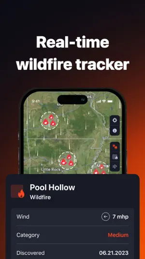
The Wildfire Tracker: wildfire maps, weather forecasts and air quality information for life in the US and your travels abroad. Check fires near your home, saved locations or next destination. Explore wildfire activity across the United States, Canada, Europe and Australia with data from trusted government agencies and NASA satellites. EXPLORE WILDFIRE MAPS View satellite-detected fire hotspots, reported wildfires and available fire boundaries on an interactive map. Check affected areas near your home, saved locations or next travel destination. Track wildfires across the United States to see active incidents and available details about affected areas. Monitor forest fires across Canada to check wildfire activity near your community or travel destination. Explore fire hotspots and burned areas across Europe to see where fires have been detected and which areas have been affected. View bushfire boundaries across Australia to understand the extent of affected areas and how close they are to places you care about. STAY INFORMED AT HOME AND AWAY Receive wildfire alerts for your saved locations and your automatically detected current location. View US National Weather Service warnings, watches, alerts and statements as interactive polygons. Press and hold a polygon to read the details. Check fire activity near your destination before and during your trip. Save locations to quickly revisit the places you care about. CHECK WEATHER AND WIND Access weather forecasts for locations worldwide. View temperature, precipitation amount and probability, wind speed and direction, visibility, humidity and pressure. Explore the animated wind map to understand wind conditions around affected areas. MONITOR AIR QUALITY Check the Air Quality Index at home or at your destination. Explore hourly air quality forecasts for up to 84 hours. See the primary pollutant and detailed pollutant information with Premium. MAKE THE MAP YOURS Choose standard, hybrid or satellite maps. Find places using text search, your current location or a tap on the map. Save locations for quick access. Filter fires by type, size and date first detected to focus on the information that matters to you. TRUSTED DATA SOURCES Our sources include the National Interagency Fire Center, Canadian Interagency Forest Fire Centre, NASA, the European Forest Fire Information System (EFFIS), part of the Copernicus Emergency Management Service, and Geoscience Australia. Available fire details and update frequency vary by source and region. GET THE WILDFIRE TRACKER PREMIUM Extended 14-day weather forecasts. Hourly weather forecasts. Detailed air pollutant information. Ad-free usage. Stay informed about wildfires, understand conditions around you and plan safer travels. Payment will be charged to your App Store account when you confirm your purchase. Subscriptions renew automatically unless you turn off auto-renewal or cancel at least 24 hours before the current subscription or trial period ends. Your account will be charged for renewal according to your chosen plan. Any unused portion of a free trial is forfeited if you purchase a Premium subscription during the trial. Manage or cancel your subscription in your App Store account settings. Privacy Policy: https://retenica.com/privacy_policy Terms: https://retenica.com/terms_of_use
Ratings & reviews
4.5
178 ratings
What’s new
Version 3.0.0 · Updated September 15, 2026
What’s new in 3.0.0 More wildfire coverage. At home and on your travels. Planning a trip to Europe or Australia? Check wildfire activity near your destination with our newly added data: • Europe: fire hotspots and burned areas from EFFIS, part of the Copernicus Emergency Management Service. • Australia: bushfire boundaries from Geoscience Australia, helping you see the extent of affected areas. Wildfire Tracker now covers the U.S., Canada, Europe, and Australia, using data from trusted government sources and NASA satellites. Stay informed wherever you go and plan safer travels.
App privacy
The developer, Retenica SP Z.O.O, reported these privacy practices to Apple.
Data Not Linked to You
The following data, which may be collected but is not linked to your identity, may be used for the following purposes:
- Identifiers: User ID, Device ID
- Usage Data: Product Interaction
- Diagnostics: Crash Data
- Purchases: Purchase History
- Location: Precise Location, Coarse Location
Used for: Analytics, Product Personalization, App Functionality
Alternatives to The Wildfire Tracker: Fire Map
Looking for apps like The Wildfire Tracker: Fire Map? Here are 6 similar apps on the App Store. The highest rated is Wildfire Map Tracker (5.0/5), and all 6 are free to download.
-
 Wildfire Map Tracker
5.0
Wildfire Map Tracker
5.0
-
 Wildfire Info
3.4
Wildfire Info
3.4
-
 Active Wildfire Tracker Map
2.3
Active Wildfire Tracker Map
2.3
-
 Wildfire Aware®
4.5
Wildfire Aware®
4.5
-
 WildFire-Ready
4.1
WildFire-Ready
4.1
-
 Alberta Emergency Alert
4.9
Alberta Emergency Alert
4.9
| App | Rating | Price | Last updated |
|---|---|---|---|
| The Wildfire Tracker: Fire Map | 4.5 / 5 (178 ratings) | Free | September 15, 2026 |
| Wildfire Map Tracker | 5.0 / 5 (1) | Free | Sep 14, 2026 |
| Wildfire Info | 3.4 / 5 (31) | Free | Jan 24, 2025 |
| Active Wildfire Tracker Map | 2.3 / 5 (13) | Free | Jan 29, 2025 |
| Wildfire Aware® | 4.5 / 5 (24) | Free | May 16, 2026 |
| WildFire-Ready | 4.1 / 5 (7) | Free | Jun 20, 2026 |
| Alberta Emergency Alert | 4.9 / 5 (61) | Free | Aug 29, 2026 |