

Pilots Weather
ITALDRONI SRL Weather iPhoneiPadiPod touch
Pilots Weather is a free Weather app for iPhone and iPad by ITALDRONI SRL. Requires iOS 16.4. Updated July 6, 2026.
- Price
- Free
- on the App Store
- Size
- 41 MB
- Age 4+
- Updated
- Jul 6
- 2026 · v1.0
Screenshots
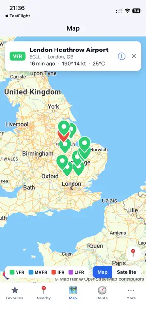
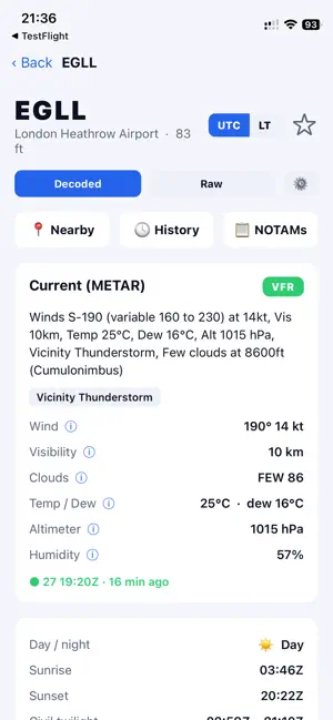
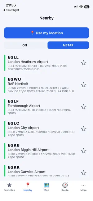

About Pilots Weather
Pilots Weather turns raw METARs and TAFs into clear, decoded aviation weather for any airport in the world. Whether you fly every week, are training for your license, or simply love aviation, it makes preflight weather fast to read and easy to understand. CORE WEATHER • Live METAR & TAF, fully decoded into plain language — or flip to raw with one tap. • Flight category at a glance: VFR / MVFR / IFR / LIFR, color-coded across lists, map and badges. • Night-VFR (NVFR) flagged automatically when conditions are VFR but the sun is below civil twilight. • Worldwide coverage — any reporting airport on the planet. FIND & FOLLOW AIRPORTS • Favorites you can drag to reorder and edit. • Nearby airports by your location, sorted by distance with bearing — tap to see live METAR inline. • Map station picker with flight-category-colored pins and instant summary cards. • Smart search by ICAO, IATA, or city. BUILT FOR DECISION-MAKING • Per-runway crosswind, headwind & tailwind — every runway end, best into-wind highlighted. • Performance data: density altitude, pressure altitude, ISA deviation, freezing level, heat index & wind chill. • Sun & Moon: sunrise, sunset, civil twilight, moon phase & illumination. • TAF timeline with min/max temperature and wind-shear callouts. • Decoded weather & remarks: sea-level pressure, peak wind, hourly precipitation and more. PLAN THE WHOLE FLIGHT • Route briefing — enter departure and destination to plot en-route airports on a map, each with live weather and the most restrictive TAF category. • NOTAMs per airport for real-world flight prep. • Historical METAR back to 2016 — pick any date and review past conditions. STAY AHEAD • Push alerts when a saved airport changes flight category (VFR ⇄ MVFR ⇄ IFR ⇄ LIFR). MADE TO FIT YOU • UTC ⇄ airport-local time toggle. • Per-quantity units (wind, temperature, altitude, visibility, pressure, distance, coordinates) — or keep original station units. • Customizable station view — reorder or hide the sections you care about. • 6 languages, light & dark mode, and an iPad-optimized two-pane layout. FAST & PRIVATE • Location is used only to find nearby airports — never stored or shared. • Efficient shared caching means fresh data without draining your battery or network. Every airport. Decoded. Important: Pilots Weather is designed for situational awareness and flight-planning support. Always confirm with official sources before every flight.
App privacy
The developer, ITALDRONI SRL, reported these privacy practices to Apple.
Data Not Linked to You
The following data, which may be collected but is not linked to your identity, may be used for the following purposes:
- Location: Precise Location
- Identifiers: Device ID
- Other Data: Other Data Types
Used for: App Functionality
Alternatives to Pilots Weather
Looking for apps like Pilots Weather? Here are 6 similar apps on the App Store. The highest rated is Aviation Weather - RunwayBrief (5.0/5), and all 6 are free to download.
-
 METAR TAF 3D – Pilot Weather
-
 AirWeather - METAR & TAF
-
 Aviation Weather - RunwayBrief
5.0
-
 航空气象驾驶舱
-
 Aviation Weather: METAR, TAF
4.3
-
 Spain Weather
5.0
| App | Rating | Price | Last updated | Compare |
|---|---|---|---|---|
| Pilots Weather | – | Free | July 6, 2026 | |
| METAR TAF 3D – Pilot Weather | – | Free | Oct 14, 2026 | Compare |
| AirWeather - METAR & TAF | – | Free | Oct 9, 2026 | Compare |
| Aviation Weather - RunwayBrief | 5.0 / 5 (1) | Free | Oct 6, 2026 | Compare |
| 航空气象驾驶舱 | – | Free | Apr 29, 2026 | Compare |
| Aviation Weather: METAR, TAF | 4.3 / 5 (13) | Free | Oct 10, 2026 | Compare |
| Spain Weather | 5.0 / 5 (1) | Free | Sep 7, 2026 | Compare |
Compare Pilots Weather with the top alternatives: ratings, updates, ASO score and keyword gaps →