

METAR TAF 3D – Pilot Weather
Serkan arslan Weather iPhoneiPadiPod touch
METAR TAF 3D – Pilot Weather is a free Weather app for iPhone and iPad by Serkan arslan. Requires iOS 17.0. Updated September 24, 2026.
- Price
- Free
- on the App Store
- Size
- 10 MB
- Age 4+
- Updated
- Sep 24
- 2026 · v3.7.7
Screenshots

About METAR TAF 3D – Pilot Weather
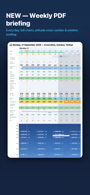
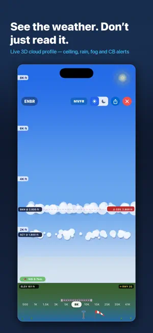
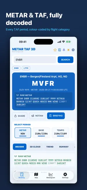
Read a METAR at a glance — then see it. METAR TAF 3D turns raw aviation weather into a picture: an animated 3D cloud profile with the real ceiling, visibility and precipitation for the airport you are flying to, plus a 14-day meteogram built for pilots rather than for the general public. SEE THE SKY, NOT A STRING OF CODE • Animated 3D cloud profile — layers at their true heights, live rain and snow • Ceiling and visibility marked where they actually are • Day and night rendering that follows the sun at that airport • Active runway and wind indicator on the ground band EVERY CODE EXPLAINED, WITH ITS SOURCE • Tap any code in a raw METAR or TAF for a plain-language explanation • 128 codes covering the international ICAO format plus the national remark sections most pilots never learn: US RMK groups, Canadian cloud-type remarks, UK and NATO colour states • Every definition is cited to the document it comes from — FAA AC 00-45H, WMO No. 306, the NWS ASOS User's Guide, MANOBS — with a link to the original • Searchable glossary grouped by country A METEOGRAM BUILT FOR PILOTS • 14 days of fog risk, ceiling, visibility, temperature/dew point spread • Turbulence and icing bands, freezing level, density altitude • Winds aloft from the surface to FL300 • Crosswind for the active runway, hour by hour • Multiple forecast models side by side — ECMWF, GFS, ICON, GEM — and a consensus blend FULL PRE-FLIGHT PICTURE • Decoded METAR and TAF with BASE, TEMPO and BECMG periods • Aviation briefing: flight category, QNH, density altitude, winds aloft • NOTAMs and PIREPs • Weather map with flight-category colouring and a model wind rose • Runway compass with crosswind and headwind components • Worst-weather scan across your airports • Notes with freehand drawing, favourites, home-screen widget • Spoken briefing in nine languages BUILT ON OFFICIAL DATA Observations and forecasts come from NOAA/NWS and Open-Meteo. Runway data comes from published aerodrome records. Nothing in the decoder is guessed: where a code could not be verified against an official document, it is left out rather than invented. Nine languages: English, Turkish, German, Spanish, Italian, Japanese, Russian, Chinese, Malay. METAR TAF 3D is a situational-awareness aid. It is not a substitute for an official weather briefing or for the pilot-in-command's judgement.
What’s new
Version 3.7.7 · Updated September 24, 2026
Plans are simpler: one yearly plan with a 3-day free trial. After the trial the free plan keeps raw METAR/TAF for one airfield a day; every module is Pro. Long-time users get a transition period — shown inside the app.
App privacy
The developer, Serkan arslan, reported these privacy practices to Apple.
Data Not Linked to You
The following data, which may be collected but is not linked to your identity, may be used for the following purposes:
- Location: Precise Location
- Identifiers: Device ID
Used for: Analytics, App Functionality
Alternatives to METAR TAF 3D – Pilot Weather
Looking for apps like METAR TAF 3D – Pilot Weather? Here are 6 similar apps on the App Store.




| App | Rating | Price | Last updated |
|---|---|---|---|
| METAR TAF 3D – Pilot Weather | – | Free | September 24, 2026 |
| Airinfo Viewer | – | Free | Aug 23, 2026 |
| ShadePilot | – | Free | Aug 19, 2026 |
| WeatherMetro | – | Free | Sep 9, 2026 |
| Aerglo | – | Free | Jul 6, 2026 |
| Cloudo: Weather Intelligence | – | Free | Sep 18, 2026 |
| Skyki! | – | Free | Mar 3, 2026 |