

TacMap
Christian Brooker Navigation iPhoneiPadiPod touch
TacMap is a free Navigation app for iPhone and iPad by Christian Brooker. Requires iOS 16.3. Updated October 13, 2026.
- Price
- Free
- on the App Store
- Size
- 10 MB
- Age 4+
- Updated
- Oct 13
- 2026 · v3.0.5
Screenshots


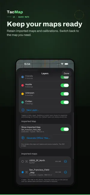
About TacMap
TacMap is an offline map for the field: unlock once, with no subscription. No TacMap account, ads or behavioural analytics. Built for hiking, hunting, overlanding, search and rescue, surveying and MGRS navigation. MAPS WITHOUT A CONNECTION • Import PDF, GeoPDF and MBTiles maps and keep several to switch between. • GeoPDFs are placed in the sheet's own projection and datum, so the MGRS grid lines up with the printed grid. • Calibrate a plain PDF, including a scan or photo of a paper map saved as PDF, from three or more grid references (MGRS, UTM or latitude/longitude) and see how accurate each one is. • Maps stay sharp as you zoom in, and can be saved as offline tiles. • Use imported maps offline, without country restrictions. • Online basemaps, terrain elevation and weather are optional and require a connection. NAVIGATE AND PLAN • Read your position in MGRS, UTM or latitude/longitude. • Keep the map North Up or rotate it with your heading. • Measure distances, areas and bearings in degrees or NATO mils. • Add waypoints, draw lines and areas, and organise them into layers. • Use search-and-rescue, points-of-interest, airsoft and NATO APP-6 symbols. • Record your route and export GPX tracks. • See the elevation profile and line of sight along any line. Uses online lookups. • Red night mode protects your night vision. • Offline sun and moon times, and range rings around any symbol. WORK TOGETHER • Share drawings and symbols with your team over end-to-end encrypted Unit Sync. • Optionally share your callsign, position and heading with your unit. • Send encrypted text or reports to the room or a selected live unit with TacMap Chat. • Screen-off location sharing has a separate switch. Updates depend on the operating system and connection. • The relay cannot decrypt mission content, but sees admission, routing, session and control data, Chat recipients, IP addresses, timing and data size. “Routed” is not delivery or read proof; member status is relay-reported. YOUR DATA, YOUR TOOLS • Import and export GeoJSON, KML and KMZ, for QGIS, Google Earth and ATAK. • Export mission objects together; recorded tracks remain separate GPX files. • Mission data is encrypted in app-private storage. Imported maps remain in private, device-protected storage. • Online basemaps and lookups are off at first launch and can be enabled independently. While enabled, providers receive your IP address and requested map area, search query or coordinates. Coordinate and mission search stays on-device. • Optional Face ID or Touch ID app lock. For iPhone and iPad. ENGLISH AND GERMAN Choose English, German or Device language in Settings. Your own names, notes and messages remain unchanged. UNLOCK ONCE Try TacMap free for three days, then unlock with a one-time purchase. No subscription. The App Store shows your local price.
What’s new
Version 3.0.5 · Updated October 13, 2026
TacMap 3.0.5 • The About screen now notes that TacMap is made in Australia.
App privacy
The developer, Christian Brooker, reported these privacy practices to Apple.
Data Not Linked to You
The following data, which may be collected but is not linked to your identity, may be used for the following purposes:
- Location: Precise Location
Used for: App Functionality
Alternatives to TacMap
Looking for apps like TacMap? Here are 6 similar apps on the App Store. The highest rated is GridNav - MGRS Land Nav GPS (5.0/5), and 5 of the 6 are free to download.
-
 Red Grid MGRS - Military GPS
4.4
-
 FieldGrid: Military GPS & MGRS
-
 MapNero: Offline GIS Maps
-
 FieldNav: MGRS & UTM GPS
-
 Vera MGRS
-
 GridNav - MGRS Land Nav GPS
5.0
| App | Rating | Price | Last updated | Compare |
|---|---|---|---|---|
| TacMap | – | Free | October 13, 2026 | |
| Red Grid MGRS - Military GPS | 4.4 / 5 (13) | Free | Oct 19, 2026 | Compare |
| FieldGrid: Military GPS & MGRS | – | Free | Oct 19, 2026 | Compare |
| MapNero: Offline GIS Maps | – | Free | Oct 22, 2026 | Compare |
| FieldNav: MGRS & UTM GPS | – | 2.99 USD | Aug 1, 2026 | Compare |
| Vera MGRS | – | Free | Aug 6, 2026 | Compare |
| GridNav - MGRS Land Nav GPS | 5.0 / 5 (4) | Free | Sep 14, 2026 | Compare |
Compare TacMap with the top alternatives: ratings, updates, ASO score and keyword gaps →