
FieldGrid: Military GPS & MGRS
Grima Hdez Navigation iPhoneiPadiPod touchApple Watch
FieldGrid: Military GPS & MGRS is a free Navigation app for iPhone and iPad by Grima Hdez. Requires iOS 17.6. Updated September 23, 2026.
- Price
- Free
- on the App Store
- Size
- 11 MB
- Age 4+
- Updated
- Sep 23
- 2026 · v1.1.0
Screenshots


About FieldGrid: Military GPS & MGRS
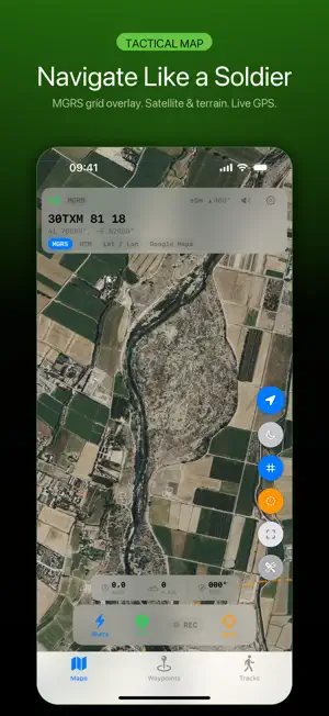
Your position as a military grid, and the tools that go with reading one. FieldGrid shows where you are in MGRS, UTM, decimal degrees and degrees-minutes-seconds at the same time, so you can read a grid to someone on a radio and plot it on a paper map without converting anything in your head. POSITION - MGRS at 100 m, 10 m or 1 m precision, with the Norway and Svalbard zone exceptions handled - UTM, decimal degrees and DMS alongside it - A second format shown under the first, your choice of which - Read the grid out loud in NATO phonetic, with Niner for nine - Home Screen widget and an Apple Watch app with the same grid MAP AND MARKS - Satellite or standard map, with a red night mode that keeps your eyes adjusted - Drop, name and categorise waypoints: OP, LZ, HQ, CP, rally, contact, hazard, medical, supply - Range rings for judging distance - Record a track and see the distance as it goes - Import and export GPX, so waypoints move between this and whatever else you use FIELD TOOLS - Lensatic compass in degrees and NATO mils - Pace counter - 9-line MEDEVAC and 9-line CAS forms, SALUTE report - Danger close reference distances by weapon system - Sun and moon rise, set and phase for your position FREE AND PRO Five waypoints on the free plan, unlimited with Pro, which also removes the ads. Everything else — the grids, the compass, the forms, the tools — is free. COMMON QUESTIONS Does it work with no signal? Your position does. GPS comes from satellites, so the grid, the compass, the waypoints and the track keep working with no bars at all. The map tiles do not: those come over the network, and without a connection you get whatever iOS still has cached. How accurate is the grid? As accurate as the phone's GPS, which is metres on a good day and worse under canopy or between buildings. A 1 m grid does not make the fix 1 m good; it just stops the app from rounding away what the fix does give you. Is the danger close table authoritative? No, and the app says so on that screen. They are published reference figures for orientation and training. They do not replace your unit's tables, the fire direction centre, or the commander's risk estimate. Does it send my position anywhere? No. Waypoints and tracks stay on the device and go to your watch. There is no account and no server. Can I get my waypoints out? Yes, as GPX, which opens in the usual mapping tools. FOR Land navigation training, hunting, hiking and backcountry, search and rescue, surveying, geocaching, and anyone who has to say where they are in a grid rather than a street address. Terms of Use: https://ghapps1.wordpress.com/terms-condition/ Privacy Policy: https://ghapps1.wordpress.com/privacy-policy/
What’s new
Version 1.1.0 · Updated September 23, 2026
The voice readout stayed silent half the time. Speaking the grid never set up an audio session, so with the ring switch on silent the phone said nothing at all, and with music or a podcast playing the two fought over the output. It now speaks over the silent switch, ducks whatever is playing, and puts the volume back afterwards. Five tests cover the phonetic readout itself, which nothing checked before — including Niner for nine. The Danger Close screen now carries a line saying what it is: published reference figures for orientation and training, not a fire-support authority, and not a replacement for your unit's tables or the commander's risk estimate. It is written in the eleven languages this app is sold in. The App Store page also named another company's app as a comparison, in the description and in the Japanese and Korean app names. That is gone, along with the duplicated terms and privacy links.
App privacy
The developer, Grima Hdez, reported these privacy practices to Apple.
Data Used to Track You
The following data may be used to track you across apps and websites owned by other companies:
- Usage Data: Advertising Data
Data Not Linked to You
The following data, which may be collected but is not linked to your identity, may be used for the following purposes:
- Usage Data: Advertising Data
Used for: Third-Party Advertising
Alternatives to FieldGrid: Military GPS & MGRS
Looking for apps like FieldGrid: Military GPS & MGRS? Here are 6 similar apps on the App Store. The highest rated is GridNav - MGRS Land Nav GPS (5.0/5), and all 6 are free to download.
-
 GridNav - MGRS Land Nav GPS
5.0
-
 10digit — MGRS GPS
5.0
-
 Red Grid MGRS - Military GPS
4.4
-
 MGRS Offline Map Satellite
-
 MGRS@Work
4.0
-
 Alpine Quest: Tactical GPS Pro
5.0
| App | Rating | Price | Last updated | Compare |
|---|---|---|---|---|
| FieldGrid: Military GPS & MGRS | – | Free | September 23, 2026 | |
| GridNav - MGRS Land Nav GPS | 5.0 / 5 (4) | Free | Sep 14, 2026 | Compare |
| 10digit — MGRS GPS | 5.0 / 5 (5) | Free | Sep 25, 2026 | Compare |
| Red Grid MGRS - Military GPS | 4.4 / 5 (13) | Free | Oct 1, 2026 | Compare |
| MGRS Offline Map Satellite | – | Free | May 28, 2026 | Compare |
| MGRS@Work | 4.0 / 5 (1) | Free | Sep 15, 2026 | Compare |
| Alpine Quest: Tactical GPS Pro | 5.0 / 5 (7) | Free | Oct 7, 2026 | Compare |