

Speed Vario
Thierry Maeder Sports iPhoneiPadApple Watch
Speed Vario is a free Sports app for iPhone and iPad by Thierry Maeder. Requires iOS 17.6. Updated October 11, 2026.
- Price
- Free
- on the App Store
- Size
- 74 MB
- Age 4+
- Updated
- Oct 11
- 2026 · v3.3
Screenshots


About Speed Vario
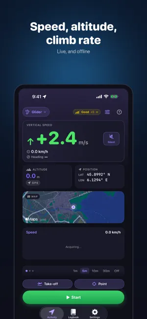
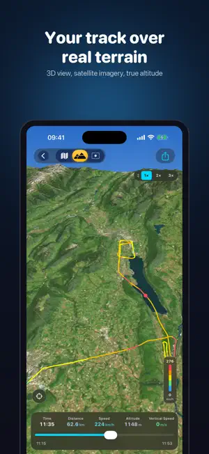
Speed, altitude, climb rate: the three numbers that matter when you are moving, live, on your wrist or in your pocket. Speed Vario is the instrument for cyclists, hikers, skiers, paragliders, sailors and pilots who want an accurate reading — no account, no subscription, no ads. SAY WHAT YOU ARE DOING, THE SCREEN FOLLOWS Walking, cycling, driving, skiing, paragliding, flying or on the water: every activity gets its own dashboard. On foot, pace and cadence. On skis, runs and lifts counted, with their names. In the air, QNH, flight level, airtime and the airfields you used. On the water, knots, heading, depth. Speed is measured, altitude fuses barometer and GPS, the variometer reads every climb and every sink. ON YOUR WRIST TOO On Apple Watch, everything live — and standalone recording when the iPhone stays home. Paragliding, the vario taps your wrist to the rhythm of the lift. And for heart rate, a Bluetooth strap is enough — Polar, Garmin, Wahoo and their equivalents — with or without a watch. FIND YOUR WAY Follow a route on the iPhone and the Apple Watch, with a voice when you stray: import a GPX, or draw your own on the map, snapped to the trails. Mark a point and aim at it - bearing, distance and, in flight, the glide ratio needed to reach it. In the air, your height above the ground below, and a recording that starts by itself at take-off. THEN, RELIVE THE OUTING A logbook per activity, with the totals. Your track laid over real 3D terrain, a chase camera that replays it second by second, a fly-through video to share. Compare two outings, recognise a route you have done before, export to GPX, FIT, IGC, KMZ or CSV. SAFE, AND YOURS An optional iCloud backup copies every outing to your own iCloud space and brings it back on a new iPhone — your heart rate never leaves the device. Everything works offline, down to the map and its place names. No account, no trackers, no server: your data stays yours.
What’s new
Version 3.3 · Updated October 11, 2026
FOLLOW A ROUTE On foot, by bike and on skis, choose a route before you set off and the iPhone and the Apple Watch guide you along it: the distance still to go, a voice when you leave the track and when you rejoin it, the named places as you reach them. Import a GPX file, build a route from pieces of several trails, reuse an outing you have already recorded, or draw your own on the map, point by point - it snaps to the footpaths or the roads of OpenStreetMap, with the climb worked out as you draw. The watch guides on its own, even with the iPhone out of range. And you can switch to another route without stopping the recording. AIM AT A POINT Mark where you are, place a point on the map, import the waypoints of a GPX file or pick an airfield. Aim at it and its bearing and distance appear on the live screen, on the map and on your wrist. In flight, you also get the glide ratio needed to reach it, in green when your wing can make it. START AT TAKE-OFF Paragliding and flying, tap Take-off before you leave: the recording starts by itself the moment you leave the ground, dated from that moment. On landing the app asks whether to stop - it never ends a flight on its own. THERMAL GAIN Paragliding, the height gained in the current thermal shows live, on the iPhone and on the vario page of the watch. HEIGHT ABOVE GROUND Paragliding and flying, your height above the terrain below, live on the iPhone and on the wrist. On skis, the same reading while you ride a chairlift, a gondola or a cable car. The terrain loads by itself when you set off with a connection; for a day without one, download an area in advance from Settings > Offline terrain. An outing's detail now draws the ground under your altitude curve. PLACE NAMES, OFFLINE, WORLDWIDE The offline map now names villages, hamlets, peaks and passes all over the world, from OpenStreetMap data. They download around you while you have a connection, and come along with an offline terrain area. A MAP THAT TURNS WITH YOU Tap the location button on the live map a second time and the map turns with you, heading up. ALSO Watching for a forgotten pause is now always on. The first time you open this version, four cards show you what is new. Two labels no longer get cut off on the 40 mm Apple Watch.
App privacy
The developer, Thierry Maeder, reported these privacy practices to Apple.
Data Not Collected
The developer does not collect any data from this app.
Alternatives to Speed Vario
Looking for apps like Speed Vario? Here are 6 similar apps on the App Store. The highest rated is OutDare: Paragliding (5.0/5), and all 6 are free to download.
-
 Volario: Paragliding Vario
-
 XC Log: Paragliding Log
-
 Skai: Paragliding Tracker
-
 OutDare: Paragliding
5.0
-
 Traqivo
-
 滑翔伞飞行电脑: Lift
| App | Rating | Price | Last updated | Compare |
|---|---|---|---|---|
| Speed Vario | – | Free | October 11, 2026 | |
| Volario: Paragliding Vario | – | Free | Oct 13, 2026 | Compare |
| XC Log: Paragliding Log | – | Free | Sep 6, 2026 | Compare |
| Skai: Paragliding Tracker | – | Free | Sep 16, 2026 | Compare |
| OutDare: Paragliding | 5.0 / 5 (10) | Free | Oct 12, 2026 | Compare |
| Traqivo | – | Free | Jul 30, 2026 | Compare |
| 滑翔伞飞行电脑: Lift | – | Free | Jul 1, 2026 | Compare |
Compare Speed Vario with the top alternatives: ratings, updates, ASO score and keyword gaps →