

SurfacePro - Area Caculator
EDUARD MARIUS ROBERT PANTAZI Utilities iPhoneiPadiPod touch
SurfacePro - Area Caculator is a free Utilities app for iPhone and iPad by EDUARD MARIUS ROBERT PANTAZI. Rated 5.0/5 from 1 ratings. Requires iOS 18.6.
- Rating
- 5.0
- 1 ratings
- Price
- Free
- on the App Store
- Size
- 10 MB
- Age 4+
- Updated
- Jul 30
- 2026 · v1.4
Screenshots

About SurfacePro - Area Caculator
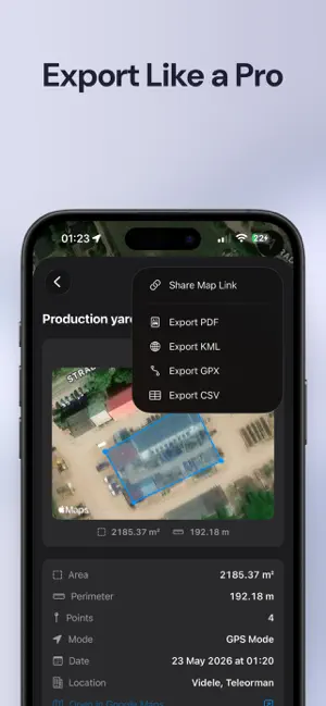
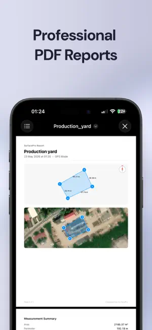
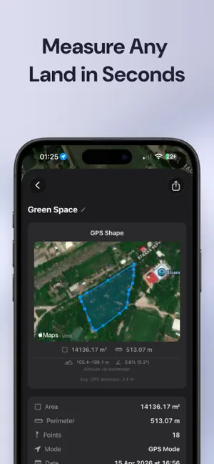
Measure any surface area with your iPhone camera (AR with LiDAR) or GPS — indoors or outdoors, small rooms or large fields. SurfacePro gives you professional area, perimeter, and terrain readings in seconds. TWO WAYS TO MEASURE AR Mode — Point your camera at any surface, tap to place points, and close the shape. Get instant area and perimeter. Works on floors, walls, yards, patios, and roofs. Enhanced accuracy with LiDAR, but works on any iPhone. GPS Mode — Two input methods: • Live GPS — Walk the perimeter and drop pins at each corner. See your polygon on a satellite map with real-time area, slope, and elevation. • Pin Placement — Tap anywhere on the satellite map to place points. Drag pins to fine-tune with a magnifier loupe for pixel-perfect positioning. Ideal for remote areas or planning from your desk. MEASURE MULTIPLE SURFACES Add multiple polygons in a single session. Completed shapes stay visible on the map while you measure the next one. Get distance analysis between polygons — perfect for calculating gaps, setbacks, or spacing. FEATURES - Real-time area and perimeter as you build your shape - Up to 100 measurement points per polygon - Distance labels between GPS points on the map - Point counter showing current vs. maximum points - Metric (m², cm) and Imperial (ft², in) units - GPS area in m², hectares, or acres - Save unlimited measurements with location tagging - Search, filter by mode, and view all saves on a map - Adjustable polygon opacity and line styles (solid, dashed, dotted) - Organise measurements into folders - Annotate diagrams resulting from AR or GPS measurements and export in PDF PROFESSIONAL EXPORT - PDF reports with shape diagrams, compass indicator, dimensions, and optional AR screenshots - GPS reports include satellite map overlay showing your polygons - KML files for Google Earth and GIS software - GPX files for mapping applications - CSV export with point coordinates and accuracy data - Share GPS measurements as map links DIAGRAM ANNOTATIONS Add text labels, arrows, circles, rectangles, and hatch fill patterns to your measurement diagrams. Move, resize, and rotate any annotation with full color customization and 30-level undo. GPS TERRAIN ANALYSIS - Min/max altitude and elevation change - Average and maximum slope (degrees and percent) - Real-time GPS accuracy monitoring - Barometric altitude for precise elevation data WORKS WITHOUT LIDAR SurfacePro uses a 3-layer accuracy system: LiDAR mesh detection, plane geometry, and estimated planes. Any iPhone with ARKit can measure surfaces — LiDAR simply gives better results on uneven terrain. PRIVACY FIRST All data stays on your device. No accounts, no analytics, no tracking, no ads. Your measurements never leave your phone. FREE TO TRY, PRO TO UNLOCK Start free with 8 points and 3 saves. Upgrade once — no subscription, no recurring fees. Unlock more points, unlimited saves, multi-polygon, all export formats, annotations, folders, distance analysis, and share links. Buy once, own it forever.
What’s new
Version 1.4 · Updated July 30, 2026
SurfacePro v1.4 adds new features like: - Annotate diagrams generated with GPS - Annotations reworked; new tools added: Dimension arrows and Pen Tool. - Fixes for AR mode measure - Onboarding added - Improved the polygon lines and markers to be easily discoverable
App privacy
The developer, EDUARD MARIUS ROBERT PANTAZI, reported these privacy practices to Apple.
Data Not Collected
The developer does not collect any data from this app.
Alternatives to SurfacePro - Area Caculator
Looking for apps like SurfacePro - Area Caculator? Here are 6 similar apps on the App Store. The highest rated is SiteScape: LiDAR Scanner & CAD (4.7/5), and all 6 are free to download.
-
 Field Area Measure on GPS Map
4.4
-
 sqft AR
4.4
-
 Measure Map Pro
4.6
-
 GPS Land Measurement & Survey
4.5
-
 SiteScape: LiDAR Scanner & CAD
4.7
-
 Moasure
4.0
| App | Rating | Price | Last updated | Compare |
|---|---|---|---|---|
| SurfacePro - Area Caculator | 5.0 / 5 (1 rating) | Free | July 30, 2026 | |
| Field Area Measure on GPS Map | 4.4 / 5 (69) | Free | Oct 7, 2026 | Compare |
| sqft AR | 4.4 / 5 (846) | Free | Dec 30, 2025 | Compare |
| Measure Map Pro | 4.6 / 5 (869) | Free | Aug 13, 2026 | Compare |
| GPS Land Measurement & Survey | 4.5 / 5 (3,009) | Free | Sep 30, 2026 | Compare |
| SiteScape: LiDAR Scanner & CAD | 4.7 / 5 (943) | Free | Aug 11, 2026 | Compare |
| Moasure | 4.0 / 5 (127) | Free | Oct 20, 2026 | Compare |