

GeoFotoUTM
Pablo Gomez Photo & Video iPhoneiPadiPod touch
GeoFotoUTM is a free Photo & Video app for iPhone and iPad by Pablo Gomez. Rated 5.0/5 from 1 ratings. Requires iOS 16.0. Updated October 18, 2026.
- Rating
- 5.0
- 1 ratings
- Price
- Free
- on the App Store
- Size
- 56 MB
- Age 4+
- Updated
- Oct 18
- 2026 · v1.7.3
Screenshots


About GeoFotoUTM
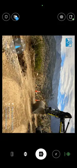
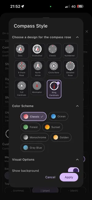
GeoFotoUTM is designed for professionals working in the field in archaeology, paleontology, flora and fauna surveys, baselines, environmental impact assessments, soil studies, cadastre, and project monitoring. The app allows you to take photos with complete geographic information integrated into the image metadata, ensuring consistency and traceability for use in reports and databases. If you require advanced customization, you can use our desktop app, also named GeoFotoUTM (available for macOS). Each photo stores: -GPS coordinates (latitude, longitude, altitude, and accuracy). - Compass orientation (azimuth). - Device tilt and orientation. - Automatic conversion to UTM coordinates. - EXIF metadata with associated geographic information. Field Workflow - Camera preview with real-time geospatial data. - Configurable overlay on the image (text, coordinates, institution, or consultancy logo). - Date and time stamp with time zone. - Utilization of the device's focus and stabilization capabilities. GeoFotoUTM aims to reduce manual post-processing work: coordinates, orientation, and altitude are already embedded in the photo, ready to be used in reports, field forms, or GIS systems. Geospatial Data - GPS reading with accuracy indicator. - Calibratable compass with signal quality warning. - 3D Orientation (pitch, roll, and heading of the device). - Coordinates in decimal, DMS (degrees, minutes, seconds), and UTM (zone and hemisphere). User Experience - Interface designed for continuous outdoor use. - Light and dark themes depending on lighting conditions. - Configuration of what information is displayed on the screen. - Adjustment of size and position of the overlaid information. Use Cases - Archaeology: Registration of sites, findings, and structures with exact coordinates and documented orientation. - Paleontology: Documentation of findings, profiles, and stratigraphic contexts with precise location. - Flora: Photographic record of plots, transects, species, and sampling points in the field. - Fauna: Documentation of sightings, traps, camera traps, and monitoring points. - Topography and Cadastre: Photographic support for surveys, boundary markings, and review of areas of interest. - Geological and Biodiversity Studies: Documentation of sampling points, outcrops, stations, and routes. Privacy and Permissions GeoFoto UTM saves photos and their metadata solely on your device. We do not send or store your information on external servers. Necessary permissions: Camera: To take photos. Location: To obtain GPS coordinates. Storage: To save images. Sensors (compass, accelerometer, and gyroscope): For device orientation and tilt. Vibration: For haptic feedback. Technical Requirements iOS 16 or higher GPS and magnetometer (compass). Accelerometer and gyroscope for tilt data. Best performance outdoors with a clear view of the sky. Tips for Improving Accuracy - Use the app outdoors with a clear view of the sky. - Calibrate the compass occasionally from within the app. - Wait for the GPS to reach reasonable accuracy before shooting. - Keep the device away from metallic objects or magnets. Supported Formats Coordinates: Decimal, DMS (degrees-minutes-seconds), and UTM. Images: JPEG with full EXIF metadata. Reference System: WGS84 (GPS) with automatic conversion to UTM. -------------------------------------- GeoFotoUTM helps you document your fieldwork with photos that already include the geographic information you need, without extra steps after shooting.
What’s new
Version 1.7.3 · Updated October 18, 2026
• The camera confirms each shot instantly, with a vibration and a sound. • If the app closes while you draw a polygon or a track, you can recover the draft. • Polygons show their names, and you can add vertices from GPS or by coordinates. • The gallery can filter by verification, for example unsigned photos. • Restoring a backup shows what will be applied and asks you to confirm. • Text no longer gets cut off with large font sizes. • If a photo can't be signed, the app tells you why.
App privacy
The developer, Pablo Gomez, reported these privacy practices to Apple.
Data Not Linked to You
The following data, which may be collected but is not linked to your identity, may be used for the following purposes:
- Identifiers: User ID
- Diagnostics: Crash Data, Performance Data
- Usage Data: Product Interaction
Used for: Analytics, App Functionality
Alternatives to GeoFotoUTM
Looking for apps like GeoFotoUTM? Here are 6 similar apps on the App Store. The highest rated is GPS Map Camera; Geotag Photo (5.0/5), and all 6 are free to download.
-
 Fiscalgov.br
-
 GPS Map Camera; Geotag Photo
5.0
-
 Geo Tag Photo & Map Camera
5.0
-
 GPS Timestamp Camera: MarkPix
-
 Timestamp Camera GPS: Fast
4.2
-
 Timestamp Camera -AI Timestamp
4.6
| App | Rating | Price | Last updated | Compare |
|---|---|---|---|---|
| GeoFotoUTM | 5.0 / 5 (1 rating) | Free | October 18, 2026 | |
| Fiscalgov.br | – | Free | Jun 3, 2026 | Compare |
| GPS Map Camera; Geotag Photo | 5.0 / 5 (3) | Free | Oct 30, 2026 | Compare |
| Geo Tag Photo & Map Camera | 5.0 / 5 (2) | Free | Oct 23, 2026 | Compare |
| GPS Timestamp Camera: MarkPix | – | Free | Oct 23, 2026 | Compare |
| Timestamp Camera GPS: Fast | 4.2 / 5 (5) | Free | Oct 1, 2026 | Compare |
| Timestamp Camera -AI Timestamp | 4.6 / 5 (819) | Free | Aug 29, 2026 | Compare |
Compare GeoFotoUTM with the top alternatives: ratings, updates, ASO score and keyword gaps →