

Maps & Outdoor Nav - Mapki
Roy Schulz Navigation iPhoneiPadiPod touch
Maps & Outdoor Nav - Mapki is a free Navigation app for iPhone and iPad by Roy Schulz. Requires iOS 26.0. Updated September 30, 2026.
- Price
- Free
- on the App Store
- Size
- 8 MB
- Age 4+
- Updated
- Sep 30
- 2026 · v1.9.3
Screenshots

About Maps & Outdoor Nav - Mapki
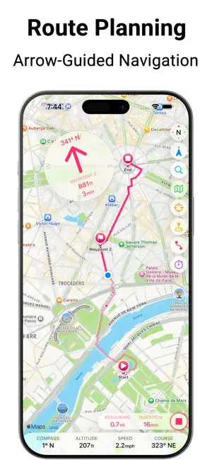
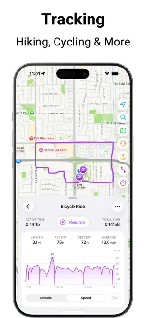
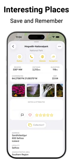
One app for all your map activities – with total privacy. Mapki is the all-in-one navigation tool that replaces countless niche apps. From outdoor adventures and water sports to professional GIS tasks, Mapki combines precise GPS features, versatile maps, and smart routing into a single powerful experience. Best of all: It works entirely without accounts – no registration required. Your data stays strictly on your device or syncs securely via your private iCloud. For all outdoor enthusiasts: • Hikers & Alpinists: Use detailed maps, plan tours with elevation profiles, and stay informed in remote areas thanks to offline caching. • Cyclists & Mountain Bikers: Benefit from specialized cycling overlays and smart routing tailored for your journeys. • Athletes & Fitness Fans: Record your activities via GPS tracking and save them as workouts in Apple Health, complete with calorie calculation. • Explorers & World Travelers: Plan your next destinations, save special places with photos and notes, and capture your favorite memories along the way. • Sailors & Skippers: Nautical units, OpenSeaMap, and Man Overboard (MOB) button for safety on the water. • GIS Experts & Professionals: Full support for UTM and MGRS coordinates, GPX-Import/Export, plus integration of custom WMTS/WMS map servers for maximum flexibility. Free Features: • Maps: Apple Maps, OpenStreetMap, OpenTopoMap, and Public Transport map. • Overlays: Specialized layers for hiking, cycling, skiing, as well as OpenSeaMap. • Offline Use: Caching of preinstalled tile-based maps and overlays. • Route Planning: Add and edit waypoints. • Navigation: Find your way along waypoints. • Tracking: Record and analyze your outdoor activities. • POIs: Search and save places, coordinates, addresses, etc. • Content: Add photos and notes to places, routes and tracks. • Sorting and Filtering: By rating, favorites, color flags & more. • Measuring: Crosshair tool to measure distance and bearing. • Units: Support for metric, US, and nautical units. • Formats: Various coordinate representations including UTM and MGRS. • Connectivity: Import & export places, routes and tracks as GPX files. • Nautical Safety: Dedicated Man Overboard (MOB) button. • More Features: GPS accuracy display, dark mode for all tile-based maps. • User-Friendly: Colors assigned to functional areas help navigating the app. • All EU languages and many more for your convenience (automatically translated; undergoing gradual review) • Language selection directly within the app – independent of the system language Additional PRO Features: • Custom Maps: Integrate any WMTS and WMS map tile server. • Custom Overlays: Add weather maps, drone no-fly zones or terrain reliefs etc. • Offline Use: Caching of all custom maps, overlays and reliefs. • Elevation: Altitude data for places and profiles for planned routes. • Smart Routing: Automatic routing for walking & hiking, cycling, or motorcycling & driving. • Advanced Navigation: Guidance along calculated routes. • Post-Processing: Trimming of GPS tracks. • Grouping: Combine places into lists and routes/tracks into multi-stage tours • Organization: Sort places, routes and tracks into collections. • Apple Health Integration: Save activities as workouts to Apple Health. • Fullscreen Dashboard: High-visibility display of all critical real-time values. The full-featured PRO version can be unlocked at any time within the app. The standard Apple Terms of Use apply: https://www.apple.com/legal/internet-services/itunes/dev/stdeula/
What’s new
Version 1.9.3 · Updated September 30, 2026
Version 1.9.3: • Bug fixes Version 1.9: • All EU languages and many more for your convenience (automatically translated; undergoing gradual review) • Language selection directly within the app – independent of the system language • New, more direct onboarding • OpenTopoMap as available map style • GPX export and MOB button now available to everyone for free • Opening hours in search results • Places can be linked to Apple map items now • Import and sharing of Apple Maps links • True undo and redo in route editing • Option to set a preferred navigation app • Live search within lists • Hide UI by shaking the device • Numerous other improvements and bug fixes
App privacy
The developer, Roy Schulz, reported these privacy practices to Apple.
Data Not Collected
The developer does not collect any data from this app.
Alternatives to Maps & Outdoor Nav - Mapki
Looking for apps like Maps & Outdoor Nav - Mapki? Here are 6 similar apps on the App Store. The highest rated is Velorino (5.0/5), and 5 of the 6 are free to download.
-
 Bike+ Die Fahrrad App!
-
 Warnemünde App für den Urlaub
-
 WindArrow
-
 Velorino
5.0
-
 Wegwiesel
-
 OffLoc - Offline GPS & SOS
| App | Rating | Price | Last updated | Compare |
|---|---|---|---|---|
| Maps & Outdoor Nav - Mapki | – | Free | September 30, 2026 | |
| Bike+ Die Fahrrad App! | – | Free | Sep 25, 2026 | Compare |
| Warnemünde App für den Urlaub | – | 0.99 USD | Aug 3, 2026 | Compare |
| WindArrow | – | Free | Mar 6, 2026 | Compare |
| Velorino | 5.0 / 5 (1) | Free | May 6, 2026 | Compare |
| Wegwiesel | – | Free | Jun 27, 2026 | Compare |
| OffLoc - Offline GPS & SOS | – | Free | Apr 3, 2026 | Compare |