

Wegwiesel
Thomas Peterson Navigation iPhoneiPadiPod touchApple Watch
Wegwiesel is a free Navigation app for iPhone and iPad by Thomas Peterson. Requires iOS 13.0. Updated June 27, 2026.
- Price
- Free
- on the App Store
- Size
- 26 MB
- Age 4+
- Updated
- Jun 27
- 2026 · v2.4.6
Screenshots

About Wegwiesel
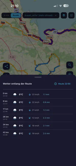
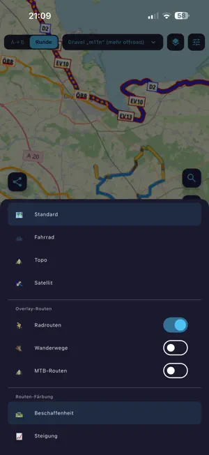
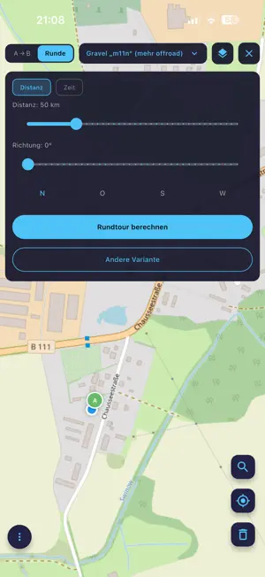
Wegwiesel is a lean, ad-free route planner for cycling, hiking, running and driving. Plan tours, navigate offline, record your rides — no account, no tracking, no subscription. ONE PLANNER, MANY PROFILES • Cycling: road, gravel, trekking, MTB, e-bike • Hiking: easy, sporty, mountain — with SAC T1–T6 grading • Running, car (130 km/h), car with trailer (80 km/h) OFFLINE-FIRST • Map tiles are cached automatically — anything you've looked at is available offline • Offline maps menu to pre-download viewports (zoom 8–15) • Real offline router with a pure-Dart A* core and trekking profile, clean fallback to BRouter • Saved routes work fully without a network LIVE NAVIGATION • Phone turn-by-turn with spoken voice (German + English) • Map heading-up or north-up, ETA shown as clock time • Automatic re-routing when you drift more than 50 m off course • Apple Watch companion: next turn, distance and remaining time on the watch face — phone stays in the pocket RECORD YOUR RIDE • GPS tracking with live stats (distance, speed, ascent, calories) • Pause/resume, GPX export when done • Crash-safe — every 10 points are flushed to disk • Share your live position: 12-hour link, no account HIKING & BIKEPACKING • Prominent hiking difficulty preset, prefer-waymarked-trails toggle • Stage planner with sunrise/sunset, weather forecast and automatic overnight suggestions • Pause recommendations: one picnic spot or shelter every 1.5 h of walking • Bikepacking mode with camping, water, shelters and train stations in the POI search DISCOVER ROUTES • Public route library: publish your tours with one tap • Filter by distance, proximity and search term • Heatmap overlay shows where the community rides SURFACE & MAP • Route colored by surface type (asphalt, paving, gravel, unpaved, offroad) • Elevation profile with hover sync, 6 color modes • Hillshading overlay for terrain context • Sights along the way with Wikipedia thumbnails EXPORT & DEVICES • GPX export for any bike computer • Push routes via Bluetooth straight to the Garmin Edge (custom Connect IQ app) • Hand off to the Wahoo Companion app (Bolt/Roam/Ace) • Import tour URLs (e.g. Komoot tour links) FOR ATHLETES • FTP test segment finder: matching climb or flat segments in a radius, scored by test type (20-min, 8-min, Ramp, Sweet Spot) WHAT WEGWIESEL DOESN'T DO • No tracking cookies, no ads, no user profiles • No subscription, no in-app purchases • No forced cloud sync Wegwiesel is a free project by a cyclist for everyone who heads outdoors. Feedback welcome. Based on BRouter and OpenStreetMap.
What’s new
Version 2.4.6 · Updated June 27, 2026
EV charging (the headline theme) - Real ad-hoc charging prices right at each station — €/kWh from the official AFIR / Mobilithek feed (10 operator feeds, ~26,000 charging points), instead of just an OSM hint. - Live availability: free / busy / out of service per station; busy ones are pushed to the bottom in the charging-stop planner, with the cheapest free one preselected. - Selectable charging stops with per-station cost and a total charging cost for the route. - Charging-card tariffs + wizard: pick your own charging card per stop (EnBW S/M/L, ADAC, Maingau, EWE Go, Shell, ad-hoc) and see the approximate cost — home-network price vs. AC/DC roaming plus blocking fee. - New: "Find free station" button in EV mode → a list of nearby free charging stations (~12 km, sorted by distance: distance · number free · €/kWh · kW); selecting one pans the map to it. Routing - Your last-used routing profile is now remembered and restored on launch. Fix - Added the INTERNET permission to the release manifest (Android release builds had no network access without it). --- Store release notes (short, EN) — to paste • EV mode: real ad-hoc charging prices and live availability (free/busy) shown at each station • Charging-card tariffs with a per-stop assistant, including cost estimates • New button: list of nearby free charging stations • Selectable charging stops with total charging cost for the route • Your last-used routing profile is now remembered • Fixed a network-access issue (Android)
App privacy
The developer, Thomas Peterson, reported these privacy practices to Apple.
Data Not Collected
The developer does not collect any data from this app.
Alternatives to Wegwiesel
Looking for apps like Wegwiesel? Here are 6 similar apps on the App Store.
-
 PedalPilot
-
 CycleLine
-
 Bike+ Die Fahrrad App!
-
 Bike GPS & Maps: Viberide
-
 Cyclo Planner: Bike GPS
-
 Instaguide: AI Travel Guide
| App | Rating | Price | Last updated | Compare |
|---|---|---|---|---|
| Wegwiesel | – | Free | June 27, 2026 | |
| PedalPilot | – | Free | Oct 2, 2026 | Compare |
| CycleLine | – | Free | Oct 8, 2026 | Compare |
| Bike+ Die Fahrrad App! | – | Free | Oct 9, 2026 | Compare |
| Bike GPS & Maps: Viberide | – | Free | Oct 2, 2026 | Compare |
| Cyclo Planner: Bike GPS | – | Free | Oct 9, 2026 | Compare |
| Instaguide: AI Travel Guide | – | Free | Aug 9, 2026 | Compare |
Compare Wegwiesel with the top alternatives: ratings, updates, ASO score and keyword gaps →