About inDTSmobile
*** PLEASE NOTE: To use inDTSmobile, it is necessary to be connected to the backend of an inVTS system provided by in-innovative navigation GmbH. ***
This app serves as frontend of an inVTS system.
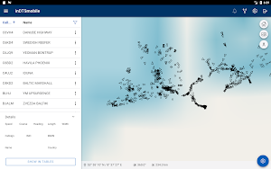
inDTSmobile provides view and management of real-time martime traffic.
It displays real-time positions of vessels along river sections or coastal waters on top of a nautical chart.
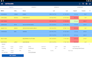
Additionally, it presents all available information about the vessels in a table view.
This app is suited to be used by port, water police and waterway authorities.
Features:
- view vessels on a live map and in a table view
- get extended vessel and voyage data from inVTS database
- notice alarms and warnings generated by inVTS Traffic Analysis System (TAS)
- request detailed information about traffic signs and other map elements
- display routes, warning areas and corridors
- examine depth contours and tide forecasts
- use on portable pilot units (PPUs)
- follow planned voyages through difficult waterway sections
- discover traffic picture in 3-D view
Similar Apps

AeroGuest
Enhance your travel experience from booking to checkout. Whether you are on...

Orca: Boat GPS, Charts, Routes
Orca - The Ultimate Boating App* Crisp online and offline nautical charts*...

Svalbard Audio - Local Guide
Discover Longyearbyen with immersive stories, beautiful photos, and a map-based audio guide...
Battlefinity - Loadouts & Meta
BATTLEFINITY – BF6 LOADOUTS, META RANKINGS, STATS, AND SETTINGSBattlefinity is the Battlefield...

Shanghai Metro Map Route上海地铁地图
Shanghai Metro Map Route app allows users to get the best route...

VesselFinder
VesselFinder is the most popular vessel tracking app, providing real-time data on...
