

Shade Walk: cool routes
Unmet Maps & Navigation Contains ads
Shade, transit & seat guidance
- Downloads
- 9.6K+
- on Google Play
- Price
- Free
- No in-app purchases
- Updated
- Oct 3
- 2026
Screenshots

About Shade Walk: cool routes
From shaded streets to a better seat on transit, Shade Walk is navigation made for people on foot.
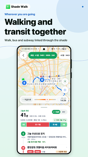
Search once to compare walking and public transit. For a transit trip, every outdoor walk—to a stop, during a transfer, and from the final stop—is evaluated at the time that segment is expected to begin. At night, sun cost is removed while your safety, slope, stairs, crowding, and street preferences still shape the route.
• Compare preference-based and shortest walking routes
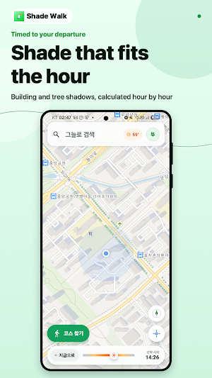
• Use building shade and, where public data is available, mapped street-tree canopies
• See shade, sun exposure, crosswalks, stairs, slopes, and underpasses
• Check buses, subways, transfers, departure and arrival times
• See stops, stations, boarding, transfer and alighting points, plus travel direction as you zoom the map
• On verified lines, see fast-transfer positions and mild-A/C car door numbers
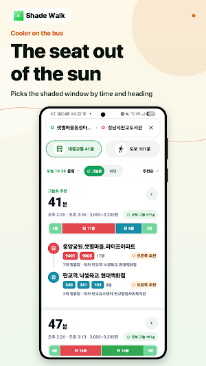
• Get an estimated cooler bus-window recommendation from sun position and travel direction
• On subway lines that may run above ground, see which side lets you sit with your back to the sun
• Hide seat guidance for subway lines without surface sections
• Preview building and street-tree shade with the time slider
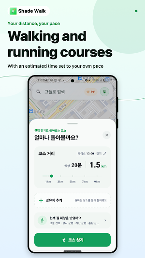
• Create shaded walking or running loops by distance and pace
• Save places, routes, and courses
Standalone walking routes are supported up to 5 km. Transit data does not include live arrivals, and schedules or fares may differ from actual service. Shadow and seat recommendations may vary with map, building, street-tree, weather, and real-world conditions.
Search once to compare walking and public transit. For a transit trip, every outdoor walk—to a stop, during a transfer, and from the final stop—is evaluated at the time that segment is expected to begin. At night, sun cost is removed while your safety, slope, stairs, crowding, and street preferences still shape the route.
• Compare preference-based and shortest walking routes
• Use building shade and, where public data is available, mapped street-tree canopies
• See shade, sun exposure, crosswalks, stairs, slopes, and underpasses
• Check buses, subways, transfers, departure and arrival times
• See stops, stations, boarding, transfer and alighting points, plus travel direction as you zoom the map
• On verified lines, see fast-transfer positions and mild-A/C car door numbers
• Get an estimated cooler bus-window recommendation from sun position and travel direction
• On subway lines that may run above ground, see which side lets you sit with your back to the sun
• Hide seat guidance for subway lines without surface sections
• Preview building and street-tree shade with the time slider
• Create shaded walking or running loops by distance and pace
• Save places, routes, and courses
Standalone walking routes are supported up to 5 km. Transit data does not include live arrivals, and schedules or fares may differ from actual service. Shadow and seat recommendations may vary with map, building, street-tree, weather, and real-world conditions.
What’s new
Updated October 3, 2026
Usability and stability improvements.
Alternatives to Shade Walk: cool routes
Looking for apps like Shade Walk: cool routes? Here are 6 similar Android apps on Google Play. All of them are free to download.





| App | Rating | Price | Installs | Last updated | Compare |
|---|---|---|---|---|---|
| Shade Walk: cool routes | – | Free | 5,000+ | Oct 3, 2026 | |
| ViberTAXI ВайберТАКСИ Водитель | – | Free | 100+ | – | Compare |
| Pickwho | – | Free | 500+ | – | Compare |
| Luono | – | Free | 50+ | – | Compare |
| Диспетчерская Служба | – | Free | 1+ | Jul 8, 2026 | Compare |
| An Đồ | – | Free | 1+ | – | Compare |
| أطلس حدائق أكتوبر | – | Free | 500+ | Sep 1, 2026 | Compare |
Similar apps on Google Play
- ViberTAXI ВайберТАКСИ Водитель
- Shade Walk: cool routes
- Pickwho
- Luono
- Диспетчерская Служба
- An Đồ
- أطلس حدائق أكتوبر
- GPS Speedometer and Odometer
- SG Bus Arrival : Live Timing
- Cuando Llega Mi Bondi
- E0 Finder : Ethanol Free Fuel
- HereNow: Location Share
- iCode
- Départ Services
- Live Earth Map - GPS Satellite
- SIM Santa Maria
- Oncore
- Reysko: Accessible Transit
- SBF - Silent But Fast
- Phone Locator & GPS Tracker
- TransEat Delivery App
- İller Arası Radar
- iCode Driver
- 168司機雷達 - 路況、計程、跑車記帳神器
- Narrow View Canal Map