Hikers Assistant+
HA+ takes hiking to the next level. Safely plan and execute any hike or trek!
About Hikers Assistant+
HA+ takes hiking to the next level. Safely plan and execute any hike or trek!
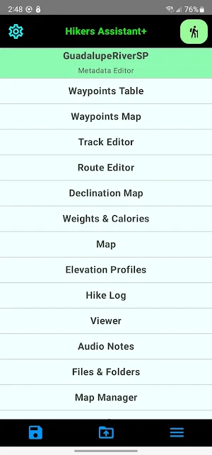
With HA+ you create, import/export (via GPX files), and use trail systems containing waypoints, routes, and tracks. Whether you are doing training with day hikes, overnighters at a state park, or a multi-day trek, HA+ lets you plan, safely execute, and record your outing. You can share your trails and hike logs with friends or fellow hikers. Hike safe, and use Hikers Assistant Plus.
No subscriptions and no in-app purchases are required.
KEY FEATURES
An off-trail planning module lets you import or create trail systems with GPX compliant waypoints, routes, and tracks.
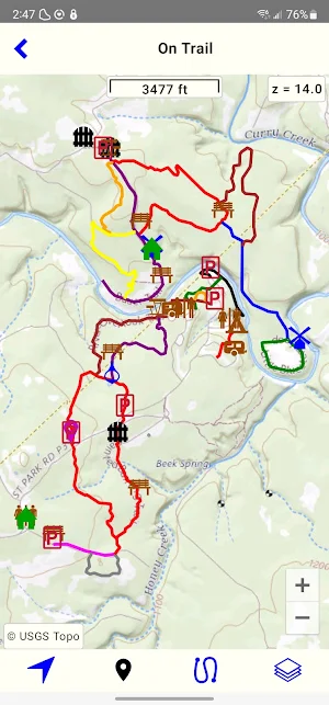
Download Google maps with internet access for pre-trip planning or USGS maps (topographic, satellite, hydrography, contours, etc.) for offline use while you are on the trail.
If you are planning to hike a known trail, search the internet and download a trail’s GPX file. If one isn’t available, you might export a trail with a couple of clicks using Gaia, Garmin or another web application. If those don’t meet your needs, download a USGS map, and trace the trail with a series of presses on your phone or tablet.
Highlight trailheads, camping spots, water sources or other sites by creating waypoints on a map using a large variety of icons.
Add and import declinations (variation between magnetic and true north) for later on-trail use where you might not have internet access.
Import static maps or other documents (PDF, JPG, PNG) for viewing on the trail.
Load your weight and rough pack weight for use in calorie estimates on your hikes.
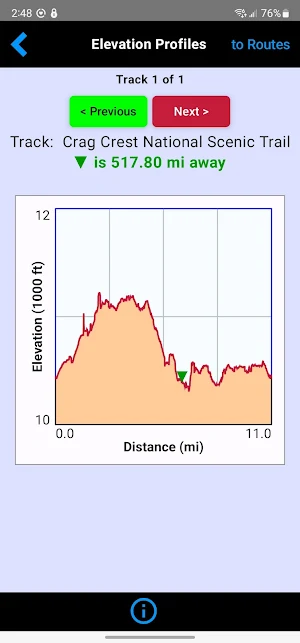
View your data before you hike in an off-trail interactive map or in elevation profiles of your routes and/or tracks.
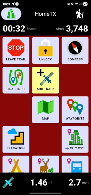
An easy-to-see on-trail module uses large buttons/icons, text, and high contrast to support your route finding on the trail.
Start hikes using GPS tracking and/or your phone’s pedometer, or just use your prepped and loaded trail system to do periodic checks on your location. Logging the hike provides continuous updates in a progress bar containing distance hiked, average speed, total steps, and elapsed time. Hike data is stored in a hike log available in the off trail planning module.
An on-trail map shows all of your data, lets you center on your location, orient the map according to the device heading, or follow your motion and/or heading. You can change the basemap to any downloaded map, as well as turn on/off waypoints, routes, and tracks. Touching a waypoint lets you bring up a compass with distance and heading to the waypoint.
A trail fix button brings up the distance and bearing to the closest point on the trail, and a button to open a compass to point to that point.
You can also list all waypoints, ordered by distance, where you can touch one to again bring up a compass with distance and bearing.
An elevations button lets you see your trail(s) elevation profiles, with the closest route or track first. On the closest trail, you also see a marker showing your position.
Other buttons let you bring up a basic compass, add a waypoint, add an audio note, add a campsite, and bring up a viewer to see any static maps or documents you’ve assigned to your trail system.
OTHER IMPORTANT INFORMATION
For on-trail use, your device needs cellular/GPS capability. The on-trail module is specifically designed to run offline and minimize power usage. Trip planning, however, can be completed on a WiFi-only device.
Offline map downloads rely primarily on USGS servers. Trail systems could be configured for non-US locations, but on-trail maps would have only a solid color basemap.
CAUTION: USGS occasionally changes their map server URL's and configurations. This could prevent some offline downloads until the next app update.
GPS tracking uses significant power, and should therefore be used with caution.
Nothing in the app is unsuitable for children's viewing; however children should always be accompanied by an adult while hiking.
Hikers Assistant+ details
Hikers Assistant+ is a paid Maps & Navigation app for Android with 0+ installs on Google Play and a 5.0/5 average rating from 1 rating. It was released on December 5, 2023 and last updated on July 26, 2025. It requires Android 8.0 or later.
- Category
- Maps & Navigation
- Rating
- 5.0 / 5 (1 rating)
- Installs
- 0+
- Price
- $0.99
- In-app purchases
- No
- Ads
- No ads
- Current version
- 2.4.0
- Requires Android
- 8.0
- Content rating
- Everyone
- Released
- December 5, 2023
- Last updated
- July 26, 2025
What’s new in Hikers Assistant+
- Modified all screens to support Android's edge-to-edge capability - Enhanced Google services code - Improved several screen layouts - Fixed minor bugs
Version 2.4.0 · Updated July 26, 2025
Similar Apps

HyperList
HyperList is a full-featured, but lightweight, app for creating and using Lists...

Hikers Assistant+
HA+ takes hiking to the next level. Safely plan and execute any...
