
SeaPilotApp
SeaPilotApp Maps & Navigation
Marine navigation program that receives AIS data via Wi-Fi (TCP/UDP)/ Bluetooth
- Downloads
- 904+
- on Google Play
- Price
- Free
- No in-app purchases
- Updated
- Oct 15
- 2026 · v5.0.6.1
Screenshots
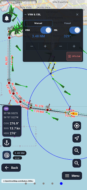


About SeaPilotApp
Built for real use, SeaPilotApp focuses on fast readability, simple connection workflows, and useful tools for close‑quarters operations.
What you can do in the current build:
Connect to AIS / NMEA sources
Wi‑Fi (TCP)
Wi‑Fi (UDP)
Bluetooth
Easy setup with IP/Port (Wi‑Fi) and quick connect / disconnect.
Live NMEA/AIS stream & log:
View raw incoming NMEA/AIS sentences in real time
Built‑in AIS Data Log for monitoring and testing
Useful for validating data streams from AIS receivers, GNSS devices, bridge systems and log exports.
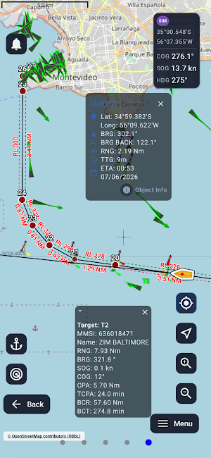
Sea Map (osmdroid):
Online layers (internet required; depends on provider availability)
OpenSeaMap overlays (seamarks / marine overlays) when available
Map orientation modes (North Up / Course Up / Free rotation)
Offline maps (no internet required):
Import and use offline map files stored on your device:
MBTiles (.mbtiles) — raster tile packages (PNG/JPEG)
Mapsforge (.map) — vector offline maps
Offline maps are used locally on the device and must be downloaded by the user separately.
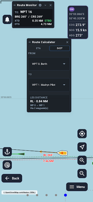
Route Planning (GPX / RTZ):
Load voyage plans, edit waypoint list, save/unload routes
XTE corridors (cross‑track error boundaries) for route monitoring
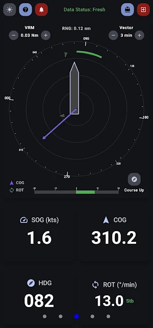
Dynamic vessel data screens:
Dedicated screens for key real‑time values such as SOG, COG, HDG, ROT (as available from your AIS/NMEA source).
Docking / manoeuvring helper screen:
A VRM‑style docking screen designed to be readable during close‑quarters operations.
Optional display of nearby vessels/targets (when AIS targets are available)
GPS screen:
A separate screen showing phone GPS data (position, SOG/COG, local time), independent from AIS input (when available).
Test Mode (no hardware required):
Replay a text file with NMEA/AIS sentences and simulate a live stream.
Alarms (safety support):
Collision Risk (CPA/TCPA)
Anchor Drag (Anchor Watch)
GPS Loss
Route Deviation
Arrival to Waypoint
Privacy / Important notes:
SeaPilotApp works locally: data is not sent to any server.
SeaPilotApp is a supporting tool and is not a certified navigation system (not ECDIS). Always cross‑check with official charts and onboard equipment.
Some features require compatible AIS/NMEA equipment and local connectivity.
What’s new
Version 5.0.6.1 · Updated October 15, 2026
• Added configurable data tiles on Second and Docking screens. • Improved Quick Menu with RM/TM map motion, AIS True/Relative vectors, and Docking Motion controls. • Added Docking own-ship offset and improved Docking layouts/interaction. • Marine ECDIS Dark is now the default theme for new installs. • Improved Object Information localization and seamark details. • Improved Anchor Watch, Sea Map, offline maps/GPX, Bluetooth/AUTO connections, startup stability, and overall reliability.
User reviews

excellent, small app which just works and it is free
Alternatives to SeaPilotApp
Looking for apps like SeaPilotApp? Here are 6 similar Android apps on Google Play. All of them are free to download.





| App | Rating | Price | Installs | Last updated | Compare |
|---|---|---|---|---|---|
| SeaPilotApp | – | Free | 500+ | Oct 15, 2026 | |
| Dispatchr | – | Free | 100+ | – | Compare |
| E-Tap | – | Free | 100+ | – | Compare |
| Citygogo | – | Free | 100+ | Oct 20, 2026 | Compare |
| Orlando Florida - Bus Transit | – | Free | 100+ | – | Compare |
| A Track Fleet Manager | – | Free | 10+ | – | Compare |
| Ch7al | – | Free | 10+ | May 21, 2026 | Compare |
Compare SeaPilotApp with the top alternatives: ratings, updates, ASO score and keyword gaps →
Similar apps on Google Play
- Dispatchr
- E-Tap
- Citygogo
- Orlando Florida - Bus Transit
- A Track Fleet Manager
- Ch7al
- TrackPilot Go
- Tropiq
- DriveNC
- Winston-Salem Transit - Bus
- HRMS Attendance System
- ArxSilex MapTools
- OnFlow
- TekGo
- Refuge For All
- Vilnius Travel Essentials
- TruxSpot: Truck Parking App
- LeafTech Ag
- CargoPilot
- MyPerro
- KATNA: Metal detector and maps
- Neptuno FieldOps
- MapStack
- Pilupay
- San Jose Bus App