

SkyAero: ADS-B & Air Band SDR
PurMental Tools In-app purchases
Track ADS-B aircraft on a map and listen to VHF air band with an RTL-SDR.
- Downloads
- 98+
- on Google Play
- Price
- Free
- In-app purchases
- Updated
- Aug 29
- 2026 · v1.0.44
Screenshots


About SkyAero: ADS-B & Air Band SDR
ADS-B / Mode-S
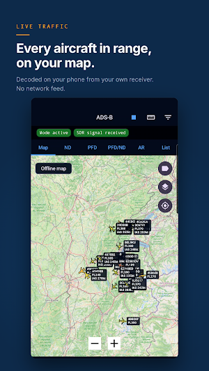
- Local 1090 MHz ADS-B and Mode-S decoding.
- Six views over the same traffic: map, navigation display, primary flight display, both instruments side by side, augmented reality, and a list.
- Live aircraft map with icons, labels, trails, altitude colouring and ground-traffic controls.
- Callsign, ICAO address, squawk, altitude, ground speed, track, heading and vertical rate, plus registration and type from the built-in aircraft database.
- Unavailable or unreliable values are shown as N/A or as dashes, never guessed.
Navigation display (ND)
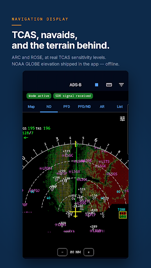
- ARC and ROSE (NAV) views, compass card, range rings and range figures.
- TCAS traffic symbols and colours, using the published sensitivity levels and thresholds.
- Track line, drift and heading bug; ground speed, true airspeed and wind in the corner block.
- Filters for how far out, and how far above or below, other traffic is drawn.
- Centred on your own position, or on a selected aircraft.
Terrain (TERR ON ND)
Offline worldwide terrain behind the traffic, from public-domain NOAA GLOBE elevation data shipped with the app - no network needed. Colour bands are measured against the altitude of the aircraft the display is centred on, with peaks mode and a brightness slider.
Primary flight display (PFD)
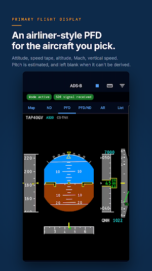
Attitude with pitch and roll, speed tape, altitude tape with the selected-altitude bracket, Mach, vertical speed and heading tape, for the selected aircraft. Barometric reference in hectopascals, inches of mercury or STD.
Mode-S air data (Comm-B)
Where a radar is interrogating the aircraft, SkyAero also decodes indicated airspeed, Mach and true airspeed, magnetic heading and roll, selected altitude and heading, the altimeter subscale (QNH) and static air temperature. Wind is derived from the aircraft's own track against its heading, using a built-in World Magnetic Model. Each field is withdrawn when it stops being refreshed, never left to go stale.
Landscape
Turn the phone sideways on either instrument for the PFD and the ND side by side, with a swappable layout that is remembered, or for the VHF receiver's own two-column panel.
Maps and aviation data
- Online map, plus an offline map option (Natural Earth).
- Aviation reference layers (OurAirports): airports and heliports, runways, airport frequencies, and navaids (VOR, VOR-DME, DME, TACAN, VORTAC, NDB).
- Runway-length filtering, optional location centering, and selectable units for altitude, speed, distance and pressure.
VHF aviation radio
- AM receiver for the 118-137 MHz air band.
- Frequency keypad with 1 kHz, 8.33 kHz and 25 kHz aviation spacing.
- Spectrum display, signal status, squelch, gain, volume, mute, PPM correction and optional noise reduction.
- Saved memories with names and favourites, and a foreground service that keeps reception running in the background.
Hardware
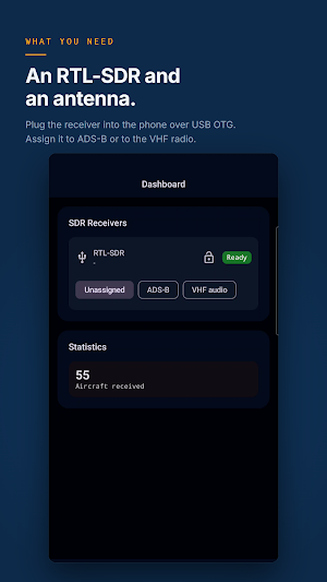
An RTL-SDR / RTL2832U receiver over USB OTG, not included. A 1090 MHz antenna is recommended for ADS-B, a VHF aviation antenna for the air band.
Privacy
Decoded radio data stays on your device and is not kept: it is the working set of the session, and it is dropped when the session ends.
Important
SkyAero is a receive-only hobby and situational-awareness app. It does not transmit, and it is not a certified instrument - do not use it for flight safety, navigation, separation or ATC decisions. The instruments show another aircraft as it broadcasts itself, and the terrain display is not a terrain awareness computer. Reception laws vary by country; you are responsible for using the app only where it is legal.
A 24-hour free trial starts when you first receive a signal, not when you sign in. Permanent access is then a single one-time purchase.
What’s new
Version 1.0.44 · Updated August 29, 2026
First public release. Plug an RTL-SDR receiver into your phone and SkyAero decodes the aircraft around you out of the air itself: ADS-B and Mode-S at 1090 MHz, on a map and on cockpit instruments drawn in the geometry of the real ones, with offline terrain behind the traffic. It also receives the VHF air band, 118 to 137 MHz. No internet feed, and nothing kept after a session.
Alternatives to SkyAero: ADS-B & Air Band SDR
Looking for apps like SkyAero: ADS-B & Air Band SDR? Here are 6 similar Android apps on Google Play. The highest rated is ASVAB Air Force Mastery 2026 (4.8/5), and all 6 are free to download.
-
Zeno Radio 4.6
-
Sea Trials - USCG License Exam 4.5
-
TrainerRoad 4.7
-
ASVAB Air Force Mastery 2026 4.8
-
ATPL Questions
-
Aeromatic: AeroPress Recipes 4.6
| App | Rating | Price | Installs | Last updated | Compare |
|---|---|---|---|---|---|
| SkyAero: ADS-B & Air Band SDR | – | Free | 50+ | Aug 29, 2026 | |
| Zeno Radio | 4.6 / 5 | Free | 1,000,000+ | Sep 21, 2026 | Compare |
| Sea Trials - USCG License Exam | 4.5 / 5 | Free | 10,000+ | Oct 29, 2026 | Compare |
| TrainerRoad | 4.7 / 5 | Free | 100,000+ | Oct 22, 2026 | Compare |
| ASVAB Air Force Mastery 2026 | 4.8 / 5 | Free | 50,000+ | Oct 1, 2026 | Compare |
| ATPL Questions | – | Free | 5,000+ | Oct 22, 2026 | Compare |
| Aeromatic: AeroPress Recipes | 4.6 / 5 | Free | 10,000+ | Mar 1, 2026 | Compare |