
Deprem Takip-Bildirim Sistemi
Tools
Real-time earthquake monitoring — instant alerts with data from AFAD, Kandilli, and EMSC.
- Downloads
- 90+
- on Google Play
- Price
- Free
- No in-app purchases
- Updated
- Aug 19
- 2026 · v1.0.1
Screenshots
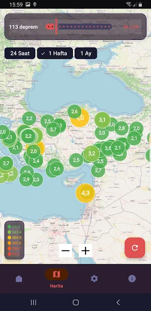


About Deprem Takip-Bildirim Sistemi
Earthquake Tracking is a free earthquake tracking application that allows you to monitor earthquakes in Turkey and around the world in real time.
Ad-free - Free!
⚠️ IMPORTANT LEGAL NOTICE
This application is not an official government application. It has no official connection with AFAD, Kandilli Observatory, or EMSC. Earthquake data is automatically obtained through the publicly available APIs of these institutions. For official and up-to-date information, please visit the official websites of the relevant institutions.
📡 DATA SOURCES
The application pulls data from the following publicly available official sources:
• AFAD (Turkish Disaster and Emergency Management Presidency)
deprem.afad.gov.tr — Turkey and surrounding areas
• Kandilli Observatory (Boğaziçi University KOERI)
koeri.boun.edu.tr — Turkey and surrounding areas
• EMSC (European-Mediterranean Seismological Centre)
seismicportal.eu — Worldwide
🔔 SMART NOTIFICATION SYSTEM
• Audible alarm for M5.0+ earthquakes — Bypasses Silent/DND mode
• Full-screen earthquake alert on lock screen
• Tsunami alert support
• Notification coverage options: - Nearby (GPS-based)
- Within a specific distance (in km)
- My country
- My continent
- Worldwide
• Minimum magnitude threshold adjustable (M1.0 – M9.0)
• Automatic notification every 30 seconds Update
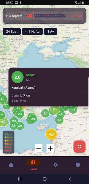
🗺️ INTERACTIVE EARTHQUAKE MAP
• Interactive map based on OpenStreetMap
• Earthquakes are shown with colored and sized circles according to magnitude
• Optional fault line layer (North Anatolian, East Anatolian, San Andreas and more)
• Viewing earthquake details on the map
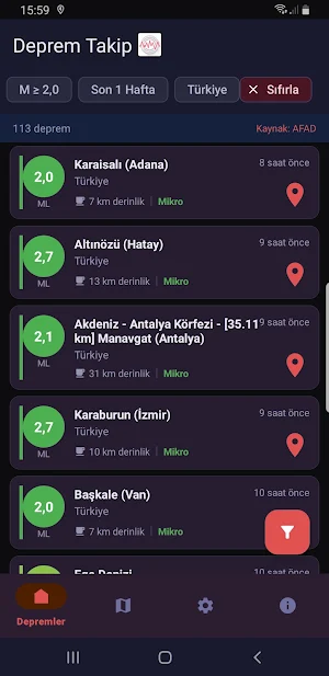
📋 EARTHQUAKE LIST AND FILTERING
• Filtering by magnitude, country, region/city and time range
• Last 1 hour / 6 hours / 1 day / 1 week / 1 month view
• Earthquakes with tsunami warnings are specially marked
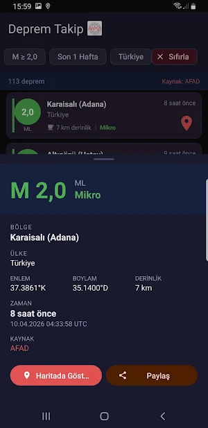
• Earthquake details: magnitude type, depth, coordinates, source
🔒 PRIVACY AND SECURITY
• No personal data is collected, copied or shared
• Location data is processed only on your device, not sent to any server
• Contains no ads, analytics or tracking SDKs
• All API connections are encrypted with HTTPS
• Open source independent This is an application.
📱 TECHNICAL SPECIFICATIONS
• Android 7.0 (API 24) and above
• Continuous background monitoring (Foreground Service)
• Automatically resumes when the device restarts
• Can be exempted from battery optimization (with user consent)
• Last data can be viewed in offline mode
Designed for your earthquake safety. Be prepared.
What’s new
Version 1.0.1 · Updated August 19, 2026
hata düzeltmeleri
Alternatives to Deprem Takip-Bildirim Sistemi
Looking for apps like Deprem Takip-Bildirim Sistemi? Here are 6 similar Android apps on Google Play. 2 of the 6 are free to download.
-
Digi Voice Radio
-
Amateur Radio Tools Pro
-
Subscription Detective
-
APRS Tracker Pro
-
MultiTools Lite
-
MultiTools Pro
| App | Rating | Price | Installs | Last updated | Compare |
|---|---|---|---|---|---|
| Deprem Takip-Bildirim Sistemi | – | Free | 50+ | Aug 19, 2026 | |
| Digi Voice Radio | – | Free | 1,000+ | – | Compare |
| Amateur Radio Tools Pro | – | 6.99 USD | 1+ | – | Compare |
| Subscription Detective | – | 3.39 USD | 0+ | Aug 20, 2026 | Compare |
| APRS Tracker Pro | – | 5.49 USD | 10+ | Aug 12, 2026 | Compare |
| MultiTools Lite | – | Free | 10+ | Aug 19, 2026 | Compare |
| MultiTools Pro | – | 3.39 USD | 5+ | – | Compare |