

RAD-TI DroneScout: UAS Zones
RAD-TI Maps & Navigation In-app purchases
Official UAS geo-zones, flight weather, light and missions: plan every flight.
- Downloads
- 100+
- on Google Play
- Price
- Free
- In-app purchases
- Updated
- Sep 25
- 2026 · v0.9.22
Screenshots


About RAD-TI DroneScout: UAS Zones
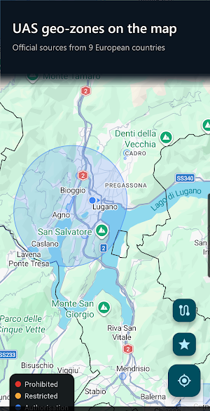
RAD-TI DroneScout shows you on the map the no-fly zones for drones and the ones that require authorisation according to the official source, across 15 European countries. Plus flight weather, light for filming and missions you can export to KML/GPX.
WHAT IT DOES
• Tap any point on the map and instantly see which zones apply to a drone flight, with source name and update time.
• Informative UAS geo-zones from official sources for 15 European countries: Switzerland (FOCA), Germany (DFS), France (DGAC/IGN), Spain (ENAIRE), Austria (Austro Control), Slovenia (CAA), Portugal (ANAC), Ireland (IAA), Luxembourg (DAC), Denmark (Trafikstyrelsen), Sweden (LFV), Finland (Traficom), Estonia (Estonian Air Navigation Services), Bulgaria (DG CAA) and Latvia (Latvijas gaisa satiksme).
• Drone altitude filter: only zones starting below 120 m AGL are shown — the ones that matter for the Open category.
• For countries without integrated data the app points you to the official national portal. In Italy you also get the airspace layer (openAIP, community data), and the reminder to check UAS zones on d-flight (ENAC) remains.
• Flight weather with the Drone Flight Score: wind at multiple altitudes, gusts, rain, visibility, thunderstorms — with a breakdown of every factor, never a blind traffic light.
• Light for filming: golden hour, blue hour, light type (hard/soft), sun position. Because a good flight is also a good shot.
• Missions: plan a waypoint route on the map, save the weather snapshot and export to KML/GPX.
• Favourite places to instantly get back to your best spots.
• In 13 languages: English, Italian, German, French, Spanish, Slovenian, Portuguese, Danish, Swedish, Finnish, Estonian, Bulgarian and Latvian.
PREMIUM (optional)
The app is free, and the safety features stay free for everyone: geo-zones, coverage warnings and the full Drone Flight Score. The Premium subscription (CHF 4.00 per month, CHF 21.00 for 6 months or CHF 38.00 for 12 months, at a discount compared to monthly; Google Play shows the price in your currency) adds:
• Unlimited missions and favourite places (free version: 3 missions, 5 favourites)
• Advanced weather detail: wind at 120 m, visibility and thunderstorms
• Unlimited KML/GPX export (free version: 3 per month)
• Backup and sync via Google Drive
Auto-renewing subscription (monthly, 6 months or 12 months, depending on the plan you choose), cancellable at any time in your Google Play settings.
IMPORTANT — READ BEFORE FLYING
RAD-TI DroneScout is an informative tool. Zone and weather data may be incomplete, outdated or temporarily unavailable and NEVER constitute flight authorisation or a safety guarantee. The pilot remains solely responsible for checking official sources and NOTAMs before every flight.
Developed by RAD-TI Riprese Aeree Drone Ticino (ripreseaereedrone-ticino.ch).
WHAT IT DOES
• Tap any point on the map and instantly see which zones apply to a drone flight, with source name and update time.
• Informative UAS geo-zones from official sources for 15 European countries: Switzerland (FOCA), Germany (DFS), France (DGAC/IGN), Spain (ENAIRE), Austria (Austro Control), Slovenia (CAA), Portugal (ANAC), Ireland (IAA), Luxembourg (DAC), Denmark (Trafikstyrelsen), Sweden (LFV), Finland (Traficom), Estonia (Estonian Air Navigation Services), Bulgaria (DG CAA) and Latvia (Latvijas gaisa satiksme).
• Drone altitude filter: only zones starting below 120 m AGL are shown — the ones that matter for the Open category.
• For countries without integrated data the app points you to the official national portal. In Italy you also get the airspace layer (openAIP, community data), and the reminder to check UAS zones on d-flight (ENAC) remains.
• Flight weather with the Drone Flight Score: wind at multiple altitudes, gusts, rain, visibility, thunderstorms — with a breakdown of every factor, never a blind traffic light.
• Light for filming: golden hour, blue hour, light type (hard/soft), sun position. Because a good flight is also a good shot.
• Missions: plan a waypoint route on the map, save the weather snapshot and export to KML/GPX.
• Favourite places to instantly get back to your best spots.
• In 13 languages: English, Italian, German, French, Spanish, Slovenian, Portuguese, Danish, Swedish, Finnish, Estonian, Bulgarian and Latvian.
PREMIUM (optional)
The app is free, and the safety features stay free for everyone: geo-zones, coverage warnings and the full Drone Flight Score. The Premium subscription (CHF 4.00 per month, CHF 21.00 for 6 months or CHF 38.00 for 12 months, at a discount compared to monthly; Google Play shows the price in your currency) adds:
• Unlimited missions and favourite places (free version: 3 missions, 5 favourites)
• Advanced weather detail: wind at 120 m, visibility and thunderstorms
• Unlimited KML/GPX export (free version: 3 per month)
• Backup and sync via Google Drive
Auto-renewing subscription (monthly, 6 months or 12 months, depending on the plan you choose), cancellable at any time in your Google Play settings.
IMPORTANT — READ BEFORE FLYING
RAD-TI DroneScout is an informative tool. Zone and weather data may be incomplete, outdated or temporarily unavailable and NEVER constitute flight authorisation or a safety guarantee. The pilot remains solely responsible for checking official sources and NOTAMs before every flight.
Developed by RAD-TI Riprese Aeree Drone Ticino (ripreseaereedrone-ticino.ch).
What’s new
Version 0.9.22 · Updated September 25, 2026
• Bulgaria: the official page the app used to find the zones is no longer public. The app now reads the CAA's latest edition file directly (30 Jul 2026), and the card shows its date. • The "official source" link for Bulgaria now opens the CAA drone section, which is online.
Alternatives to RAD-TI DroneScout: UAS Zones
Looking for apps like RAD-TI DroneScout: UAS Zones? Here are 6 similar Android apps on Google Play. All of them are free to download.



| App | Rating | Price | Installs | Last updated |
|---|---|---|---|---|
| RAD-TI DroneScout: UAS Zones | – | Free | 100+ | Sep 25, 2026 |
| İstapark (İstanbul - Park) | – | Free | 100+ | Jul 10, 2026 |
| Android Surfer | – | Free | 10+ | Sep 25, 2026 |
| Cab24 | – | Free | 1+ | Aug 22, 2026 |
| Fusion Tracking | – | Free | 100+ | Aug 10, 2026 |
| Retraker | – | Free | 5+ | Sep 14, 2026 |
| MileSync | – | Free | 5+ | Aug 22, 2026 |
Similar apps on Google Play
- İstapark (İstanbul - Park)
- Android Surfer
- Cab24
- Fusion Tracking
- Retraker
- MileSync
- Cab24 Driver
- Dex Car - Motorista
- PRK NYC
- Shadow Chase - Avoid Sunlight
- MGRS Offline Map Satellite Pro
- Shuttle Bus
- Find My Device Phone Tracker
- GoGoWee
- AFA Pasajero
- MV Locate Pro
- Visión Geográfica Suite
- SeaCheck
- ALPIK Forwarder
- GeoReminder
- Envision Charging
- NORTHERN WAY
- Saint-Jean-sur-Richelieu Bus …
- GR20 Corsica: Route Planner
- Parking Tom