

Turistautak - Hiking Paths
Maps & Navigation In-app purchases
Hungary's offline hiking app
- Downloads
- 384+
- on Google Play
- Price
- Free
- In-app purchases
- Updated
- Oct 15
- 2026 · v1.8.1
Screenshots


About Turistautak - Hiking Paths
Turistautak (pronounced "TOO-ree-shtah-oo-tahk") means hiking routes, or paths, in Hungarian. It is a simple-to-use, offline-first map and navigation app made for everyone who loves hiking in Hungary. Major features include:
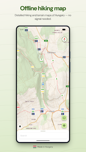
- Personalize your map! The app contains the detailed hiking and elevation map of Hungary, and it's updated on a weekly basis.
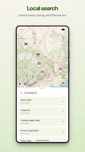
- Find exciting destinations! Local search lets you explore nearby POIs. Already know where you're going? Text-based search lets you find every hilltop, cave entrance, spring or clearing.
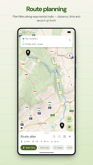
- Plan your perfect hike! Thanks to the route planner, you'll find the ideal hiking paths, and see exactly how much you're going to walk, how long it is going to take, and what elevation difference you may expect.
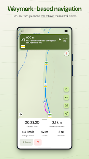
- Let's go! The way marking-aware navigation will guide you even when running in the background if you'd rather focus on your surroundings instead of the screen of your phone. Thanks to the sophisticated algorithm, the app does all this while being as battery-friendly as possible. On top of all this, automatic rerouting makes sure you don't have to worry about getting lost even if you deviate from your original path.
- Check where you've been! Whether you're navigating, or just tracking your hikes, you'll always find a detailed summary of the hike, including elevation data and average speed.
- Share with others! Export your tracks in GPX format so that others may also explore your favorite hiking paths.
- Found a promising track online? Import the GPX file, and it is displayed on your map as you like.
- Privacy friendly! The app doesn't require any registration, and your exact location will never be shared with anyone.
- Backup your hikes privately! Enable sync to keep your saved routes and hikes in the cloud — it's end-to-end encrypted.
- For night owls! Dark mode for anyone who hikes after dark.
Please note, the app only works in Hungary. A download of roughly 2 GB of map data is required to use the app. Tracking can drain your battery faster.
The app requires subscription to use. Free trial available. Cancel anytime.
Privacy Policy: https://www.turistautak.app/en/legal/pp
We strive to keep improving our app. Should you have any feedback or feature request, feel free to reach out to us on social media under @turistautak. We sincerely hope your stay in Hungary will be pleasant; see you in the great outdoors!
- Personalize your map! The app contains the detailed hiking and elevation map of Hungary, and it's updated on a weekly basis.
- Find exciting destinations! Local search lets you explore nearby POIs. Already know where you're going? Text-based search lets you find every hilltop, cave entrance, spring or clearing.
- Plan your perfect hike! Thanks to the route planner, you'll find the ideal hiking paths, and see exactly how much you're going to walk, how long it is going to take, and what elevation difference you may expect.
- Let's go! The way marking-aware navigation will guide you even when running in the background if you'd rather focus on your surroundings instead of the screen of your phone. Thanks to the sophisticated algorithm, the app does all this while being as battery-friendly as possible. On top of all this, automatic rerouting makes sure you don't have to worry about getting lost even if you deviate from your original path.
- Check where you've been! Whether you're navigating, or just tracking your hikes, you'll always find a detailed summary of the hike, including elevation data and average speed.
- Share with others! Export your tracks in GPX format so that others may also explore your favorite hiking paths.
- Found a promising track online? Import the GPX file, and it is displayed on your map as you like.
- Privacy friendly! The app doesn't require any registration, and your exact location will never be shared with anyone.
- Backup your hikes privately! Enable sync to keep your saved routes and hikes in the cloud — it's end-to-end encrypted.
- For night owls! Dark mode for anyone who hikes after dark.
Please note, the app only works in Hungary. A download of roughly 2 GB of map data is required to use the app. Tracking can drain your battery faster.
The app requires subscription to use. Free trial available. Cancel anytime.
Privacy Policy: https://www.turistautak.app/en/legal/pp
We strive to keep improving our app. Should you have any feedback or feature request, feel free to reach out to us on social media under @turistautak. We sincerely hope your stay in Hungary will be pleasant; see you in the great outdoors!
What’s new
Version 1.8.1 · Updated October 15, 2026
Fixes and improvements. As always, if you have any recommendations or ideas, or you'd like to report an issue, please contact us!
Alternatives to Turistautak - Hiking Paths
Looking for apps like Turistautak - Hiking Paths? Here are 6 similar Android apps on Google Play. The highest rated is VoiceMap: Audio Tours & Guides (4.7/5), and 5 of the 6 are free to download.
-
Pin Traveler: Travel Tracker 4.1
-
VoiceMap: Audio Tours & Guides 4.7
-
GPX Viewer PRO: Hike & Bike 4.6
-
swisstopo 4.6
-
TwoNav 6: Routes and Maps 3.0
-
TrailLink: Bike, Run, Walk 4.1
| App | Rating | Price | Installs | Last updated | Compare |
|---|---|---|---|---|---|
| Turistautak - Hiking Paths | – | Free | 100+ | Oct 15, 2026 | |
| Pin Traveler: Travel Tracker | 4.1 / 5 | Free | 100,000+ | Sep 4, 2026 | Compare |
| VoiceMap: Audio Tours & Guides | 4.7 / 5 | Free | 100,000+ | Oct 26, 2026 | Compare |
| GPX Viewer PRO: Hike & Bike | 4.6 / 5 | 8.99 USD | 100,000+ | Oct 15, 2026 | Compare |
| swisstopo | 4.6 / 5 | Free | 1,000,000+ | Aug 26, 2026 | Compare |
| TwoNav 6: Routes and Maps | 3.0 / 5 | Free | 100,000+ | Aug 3, 2026 | Compare |
| TrailLink: Bike, Run, Walk | 4.1 / 5 | Free | 500,000+ | Oct 19, 2026 | Compare |
Similar apps on Google Play
- Pin Traveler: Travel Tracker
- VoiceMap: Audio Tours & Guides
- GPX Viewer PRO: Hike & Bike
- swisstopo
- TwoNav 6: Routes and Maps
- TrailLink: Bike, Run, Walk
- JollyTango: Audio Travel Guide
- Footpath Route Planner
- Hikingbook: Hike, Bike & Run
- FarOut
- PeakVisor - 3D Maps & Peaks ID
- Trails Offroad: Offline Maps
- Avenza Maps: Offline Mapping
- Holland America Line Navigator
- Territory Helper
- Outdooractive. Hike and Ride
- bergfex: Hiking & Tracking
- izi.TRAVEL: Audio Tour Guides