

Planimeter for map measure
忠 张 Utilities iPhoneiPadiPod touch
Planimeter for map measure is a free Utilities app for iPhone and iPad by 忠 张. Rated 4.4/5 from 856 ratings. Requires iOS 17.0. Updated August 11, 2026.
- Rating
- 4.4
- 856 ratings
- Price
- Free
- on the App Store
- Size
- 48 MB
- Age 4+
- Updated
- Aug 11
- 2026 · v10.2
Screenshots

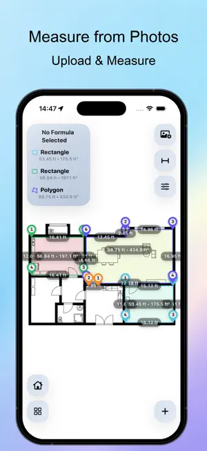


About Planimeter for map measure
How many acres is your property? What is the straight-line distance between Los Angeles and Las Vegas? How large is Central Park? How much roof space is available for a solar installation? Map Measure makes it easy to measure distance, perimeter, and area directly on maps or images. Whether you’re managing farmland, planning a construction project, estimating solar panel coverage, or exploring the outdoors, Map Measure gives you accurate measurements in just a few taps. MAP MEASUREMENT Measure directly on interactive maps with professional-grade tools. • Supports Apple Maps • Measure distance, perimeter, and area • Draw paths, polygons, circles, rectangles, and radial lines • Search locations instantly • GPS positioning and coordinate lookup • Multiple map styles and satellite imagery • Metric, Imperial, and custom units • Built-in formulas for cost estimation and calculations • Import, export, and share measurement projects IMAGE MEASUREMENT Measure directly from aerial photos, blueprints, diagrams, or any image. • Import images from your device • Calibrate using a known reference distance • Automatically calculate accurate measurements • Measure distance, perimeter, and area • Draw polygons, circles, rectangles, and custom shapes • Custom formulas for estimating materials, costs, and quantities • Export and share results PROFESSIONAL FEATURES • Measure multiple shapes within a single project • Quick tap placement or precision crosshair editing • Visual project management and history • Import and export project files • Share measurements as images or files PERFECT FOR • Landowners and ranch managers • Farmers and agricultural professionals • Construction and engineering projects • Solar panel planning and site assessment • Property and real estate evaluation • Landscaping and outdoor design • Hiking, cycling, and route planning • Surveying and mapping enthusiasts SUPPORTED UNITS • Feet, Miles, Yards • Acres, Square Feet • Meters, Kilometers • Hectares If Map Measure helps you with your work or outdoor adventures, please consider leaving a review. Your feedback helps us improve the app for everyone.
Ratings & reviews
4.4
856 ratings
What’s new
Version 10.2 · Updated August 11, 2026
- Added long‑press drag‑and‑drop for map pins, allowing fine‑tuning after editing. - Added fixed‑unit mode, enabling seamless switching between dynamic unit adjustment and fixed‑unit mode.
App privacy
The developer, 忠 张, reported these privacy practices to Apple.
Data Not Collected
The developer does not collect any data from this app.
Alternatives to Planimeter for map measure
Looking for apps like Planimeter for map measure? Here are 6 similar apps on the App Store. The highest rated is Measure Map (4.7/5), and all 6 are free to download.
-
 Measure Map Pro
4.6
-
 GPS Land Measurement & Survey
4.5
-
 Measure Map
4.7
-
 GPS Area Measurements
3.2
-
 Distance Measure
4.3
-
 GLand: GPS Field Area Measure
4.6
| App | Rating | Price | Last updated | Compare |
|---|---|---|---|---|
| Planimeter for map measure | 4.4 / 5 (856 ratings) | Free | August 11, 2026 | |
| Measure Map Pro | 4.6 / 5 (864) | Free | Aug 13, 2026 | Compare |
| GPS Land Measurement & Survey | 4.5 / 5 (3,009) | Free | Sep 30, 2026 | Compare |
| Measure Map | 4.7 / 5 (5,328) | Free | Oct 17, 2026 | Compare |
| GPS Area Measurements | 3.2 / 5 (9) | Free | Apr 13, 2024 | Compare |
| Distance Measure | 4.3 / 5 (238) | Free | May 1, 2025 | Compare |
| GLand: GPS Field Area Measure | 4.6 / 5 (612) | Free | Aug 11, 2026 | Compare |