

CityPanorama
Arnulf Friedemann Jurgen Keese Travel iPhoneiPadiPod touch
CityPanorama is a free Travel app for iPhone and iPad by Arnulf Friedemann Jurgen Keese. Requires iOS 17.0. Updated October 23, 2026.
- Price
- Free
- on the App Store
- Size
- 7 MB
- Age 4+
- Updated
- Oct 23
- 2026 · v1.1
Screenshots



About CityPanorama
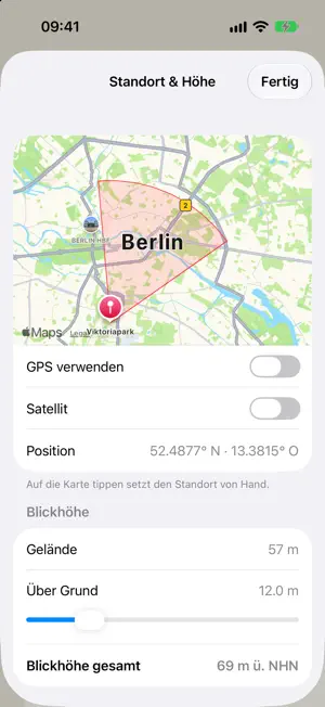
What is that tower over there? CityPanorama draws the city as you see it from where you stand — a line drawing of the skyline, with a name and a distance on every landmark. Like a peak finder, but for the city. WHERE YOU LOOK Hold the iPhone up and the drawing follows the back camera. Lay it flat and its top edge sets the direction. A sideways swipe corrects the compass where steel and concrete throw it off; the correction is kept. OVER THE CAMERA PICTURE If you like, the lines lie over the camera picture, coloured by distance: near orange, middle yellow, far light blue. You see at once which building is which. LANDMARKS, EVEN WHEN HIDDEN The TV tower, the radio tower, the big masts and the best-known places are always named. Where something stands in front, a dashed pointer shows where they are — just what you need to line up the compass. MORE THAN BUILDINGS Water in blue, large parks and woods in green, main roads in yellow, railways in red, the lie of the land in brown — each where it can be seen from your position, hidden parts left out. SET WHAT YOU WANT TO SEE • Detail: from “only what stands out” to every building with a known height • Height: stretches the silhouette up to 25 times, so flat ground becomes readable • Buildings: lowers only the houses, the ground stays • Angle scale at the edge, compass strip on top, compass rose below • Swipe the settings down when you only want the picture Data: © OpenStreetMap contributors (ODbL); terrain: Mapzen Terrain Tiles.
What’s new
Version 1.1 · Updated October 23, 2026
CityPanorama now works anywhere, not just in Berlin. Elsewhere the app downloads the surrounding map data from OpenStreetMap and keeps it on the device: terrain and landmarks first, then water and roads, then nearby buildings. Berlin keeps its full built-in detail. New steering button next to "Aktuelle Position": compass (the drawing follows the device), free (swipe to look around) or calibrate (corrects the compass, ends by itself).
App privacy
The developer, Arnulf Friedemann Jurgen Keese, reported these privacy practices to Apple.
Data Not Linked to You
The following data, which may be collected but is not linked to your identity, may be used for the following purposes:
- Location: Coarse Location
Used for: App Functionality
Alternatives to CityPanorama
Looking for apps like CityPanorama? Here are 6 similar apps on the App Store. The highest rated is Abfahrt! Live Transit Europe (5.0/5), and all 6 are free to download.
-
 Barrierefrei unterwegs
-
 Abfahrt! Live Transit Europe
5.0
-
 Call a Bike
3.3
-
 Norse Atlantic Airways
4.7
-
 VBB Bus & Bahn: Route planner
1.9
-
 MÁV
4.3
| App | Rating | Price | Last updated | Compare |
|---|---|---|---|---|
| CityPanorama | – | Free | October 23, 2026 | |
| Barrierefrei unterwegs | – | Free | Sep 30, 2026 | Compare |
| Abfahrt! Live Transit Europe | 5.0 / 5 (1) | Free | Oct 25, 2026 | Compare |
| Call a Bike | 3.3 / 5 (66) | Free | Oct 15, 2026 | Compare |
| Norse Atlantic Airways | 4.7 / 5 (5,099) | Free | Oct 19, 2026 | Compare |
| VBB Bus & Bahn: Route planner | 1.9 / 5 (20) | Free | Aug 28, 2024 | Compare |
| MÁV | 4.3 / 5 (382) | Free | Sep 30, 2026 | Compare |
Compare CityPanorama with the top alternatives: ratings, updates, ASO score and keyword gaps →