

GeoZine
江 吴 Photo & Video iPhoneiPadiPod touch
GeoZine is a free Photo & Video app for iPhone and iPad by 江 吴. Requires iOS 17.0. Updated November 13, 2026.
- Price
- Free
- on the App Store
- Size
- 19 MB
- Age 4+
- Updated
- Nov 13
- 2026 · v1.3.6
Screenshots

About GeoZine
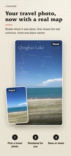
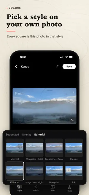
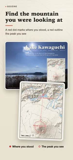
Pick a travel photo with a location. GeoZine reads where it was taken and draws the real contours, rivers and place names there, laid into one image you can post as is. A red dot marks where you stood, and one line under the title says where you are and what you are looking at. THREE STEPS 1. Pick a travel photo. Choose one that has a location. No location? Search for a place name or tap the map instead. 2. The place is drawn automatically. GeoZine reads the capture point and draws the real contours, rivers and place names there. 3. Pick a ratio, save or share. Original, 3:4, 4:5, 9:16 and 1:1, and the title and map block can be dragged wherever you like. THE DEFAULT SPOTLIGHT LAYOUT The map is the hero: the mountain or lake you are looking at is picked out in red, and the title is followed by coordinates, elevation and heading, plus one line that says where you stand and what you see. Classic, Ink and Minimal styles are still there. You can also export a magazine page: the photo is kept exactly as shot, with a paper-colored page added beside it for the title, coordinates, elevation, heading, date, a short caption and the full map. WHY THE IMAGE CAN BE TRUSTED - Contours drawn from real elevation data: they come from public elevation data, peaks carry their heights and lakes follow real shorelines. It is not an illustration. - A red dot and a line you can verify: the dot is the photo's capture point, so anyone can check it. - Your original pixels are never changed: GeoZine only lays a layer over the photo, and everything outside the map matches the original pixel for pixel. - Photos are processed on your phone and never uploaded. No account, no ad tracking. GOOD TO KNOW - An internet connection is needed each time. GeoZine downloads public map and elevation data near the capture point, usually in under half a minute. The requests contain only map tile numbers near that point, never your photo. - GeoZine draws terrain, water, roads and place names. It deliberately draws no national borders or administrative boundary lines. - Map data © OpenStreetMap contributors, OpenFreeMap. Elevation data: AWS Terrain Tiles. Questions and ideas: [email protected]
What’s new
Version 1.3.6 · Updated November 13, 2026
GeoZine 1.3.6: turn a landscape photo into a portrait image without cropping it. • Pick a taller ratio such as 3:4 or 4:5 and the whole photo stays at the bottom while the sky extends upward, with the map and title placed in the new sky • Sharing to Xiaohongshu saves two images at once: a portrait cover and a before and after comparison. Pick the cover first • Sharing uses the ratio you chose in the editor, and the editor stays as it was afterward • In Adjust, switch between Extend sky and Crop next to the ratios
App privacy
The developer, 江 吴, reported these privacy practices to Apple.
Data Not Linked to You
The following data, which may be collected but is not linked to your identity, may be used for the following purposes:
- Purchases: Purchase History
- Location: Coarse Location
- Identifiers: Device ID
- Usage Data: Product Interaction
- Diagnostics: Crash Data, Performance Data, Other Diagnostic Data
Used for: Analytics, App Functionality
Alternatives to GeoZine
Looking for apps like GeoZine? Here are 6 similar apps on the App Store. The highest rated is FotoLUT (5.0/5), and all 6 are free to download.
-
 Zapp 相机-胶片模拟与光学滤镜
-
 Gatherlight: Retro Film Camera
-
 FotoLUT
5.0
-
 Nostalgia Cam
5.0
-
 小预设
-
 LumiTone: Fill Light & Layout
5.0
| App | Rating | Price | Last updated | Compare |
|---|---|---|---|---|
| GeoZine | – | Free | November 13, 2026 | |
| Zapp 相机-胶片模拟与光学滤镜 | – | Free | Nov 10, 2026 | Compare |
| Gatherlight: Retro Film Camera | – | Free | Nov 11, 2026 | Compare |
| FotoLUT | 5.0 / 5 (1) | Free | Nov 12, 2026 | Compare |
| Nostalgia Cam | 5.0 / 5 (3) | Free | May 28, 2026 | Compare |
| 小预设 | – | Free | Nov 9, 2026 | Compare |
| LumiTone: Fill Light & Layout | 5.0 / 5 (1) | Free | Oct 25, 2026 | Compare |
Compare GeoZine with the top alternatives: ratings, updates, ASO score and keyword gaps →