

FCST – Sky & Sea Forecast
Aleksander Godzilo-Godlewski Weather iPhoneiPadiPod touch
FCST – Sky & Sea Forecast is a free Weather app for iPhone and iPad by Aleksander Godzilo-Godlewski. Requires iOS 15.0. Updated November 12, 2026.
- Price
- Free
- on the App Store
- Size
- 54 MB
- Age 4+
- Updated
- Nov 12
- 2026 · v1.2.0
Screenshots


About FCST – Sky & Sea Forecast
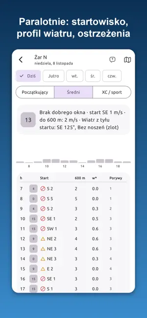
FCST is a weather forecast for air sports, sailing and the mountains. We run our own models: WRF for all of Europe (5.4 km grid, ECMWF input), mountain wave on a 1.8 km grid over southern Poland, ICON-D2 over the Alps, and the Andes in Chile. Pick your disciplines – the home screen shows 0–100 scores, the best time window and a short reason. GLIDING • Thermals: climb rate, cloud base, cloud cover, thunderstorm risk. • Ridge lift from a terrain model and wave at several heights. • Competitions from SoaringSpot: start window, route in AAT areas, conditions on each leg. • Forecast files for XCSoar. VFR FLYING • Weather along the route at your ETA: ceiling, visibility, icing, thunderstorms, wind. • Vertical cross-section of the route, METAR and TAF of airfields on the way. • Suggested route around airspace and an OpenAIP airspace map. IN-FLIGHT MAP • Your glider or airplane on the forecast map, your track and the airspace at your altitude. • Cross-section of the next 20 minutes: real terrain, cloud base, freezing level, rain, thermal top. PARAGLIDING AND PPG • Launch site scores: wind at launch and every 100 m up to the inversion, gradient, turbulence, thermals. • Pilot profile adjusts the wind limits. Launch site database built by pilots. BALLOON AND SKYDIVING • Balloon: launch windows and predicted flight trajectories. • Skydiving: wind at exit altitude and near the ground, jump hours for your drop zone. SAILING • Wind in knots and Beaufort, gusts, squalls, waves and currents. • My voyage: weather along the voyage and the best departure time. SKIING AND HIKING • Ski resorts and ski tours: snow, weather, avalanche danger. • My route: trails and weather at the real elevation of the route. Also: • 12-day weather forecast for any place and rain radar. • Notifications of good and dangerous conditions at your places. • Home screen widgets. • Offline forecast maps – work without signal. • "Who's coming" – see who is heading to the airfield or launch site. • 6 languages: English, Polish, German, Czech, French, Italian. Free: the weather forecast without limits, today's discipline forecasts and warnings. Premium (yearly subscription, 14 days free): the following days, any place, widgets with scores, alerts and offline maps. Forecasts are a planning aid, and the in-flight map is not a navigation device. They do not replace official meteorological information, a briefing or your own assessment of the conditions. Data: WRF (ECMWF), ICON-D2 (DWD), GFS (NOAA), Open-Meteo, Copernicus, OpenAIP, maps © OpenStreetMap.
What’s new
Version 1.2.0 · Updated November 12, 2026
Version 1.2.0 adds background location (UIBackgroundModes: location) for two user-started features in the Skiing profile: 1. "My day" (Skiing card → "My day – record runs" → "Record day"): records the user's ski runs (distance, vertical, speed) while the phone is in a pocket with the screen off. Recording starts only when the user taps the button and continues until they tap "Stop recording". The GPS track is stored on the device only. 2. "My team" (Skiing card → "My team – friends on the map"): friends who joined the same team (invite link or QR code, max 10 people) can see each other on the ski resort map and set a meeting point. Each member turns sharing on themselves and always for a limited time (e.g. 2 hours or until the end of the day); it stops automatically. The server keeps only the last position while sharing is on and deletes it when sharing ends. Sharing can be stopped at any time with the "Stop" button. The app asks only for "While Using the App" location permission; it never asks for "Always". The blue location indicator is visible the whole time. Location is not used for advertising or tracking. The feature is not an emergency or rescue service, which is stated in the app.
App privacy
The developer, Aleksander Godzilo-Godlewski, reported these privacy practices to Apple.
Data Not Linked to You
The following data, which may be collected but is not linked to your identity, may be used for the following purposes:
- Health & Fitness: Fitness
- Location: Precise Location
Used for: App Functionality
Alternatives to FCST – Sky & Sea Forecast
Looking for apps like FCST – Sky & Sea Forecast? Here are 6 similar apps on the App Store.
-
 Aerogram - Flight Weather
-
 Trafna Pogoda
-
 Weather Live — Local Meteo
-
 Todays Weather
-
 MeteoScope
-
 TopMetSat
| App | Rating | Price | Last updated | Compare |
|---|---|---|---|---|
| FCST – Sky & Sea Forecast | – | Free | November 12, 2026 | |
| Aerogram - Flight Weather | – | Free | Sep 30, 2026 | Compare |
| Trafna Pogoda | – | Free | Sep 13, 2026 | Compare |
| Weather Live — Local Meteo | – | Free | Nov 9, 2026 | Compare |
| Todays Weather | – | Free | Aug 14, 2025 | Compare |
| MeteoScope | – | Free | Aug 8, 2025 | Compare |
| TopMetSat | – | Free | Nov 7, 2026 | Compare |