

BushGrid
Bryan Nouwens Utilities iPhoneiPadiPod touchApple Watch
BushGrid is a free Utilities app for iPhone and iPad by Bryan Nouwens. Requires iOS 18.0. Updated October 8, 2026.
- Price
- Free
- on the App Store
- Size
- 8 MB
- Age 4+
- Updated
- Oct 8
- 2026 · v1.0
Screenshots


About BushGrid
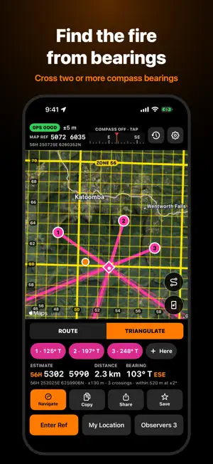
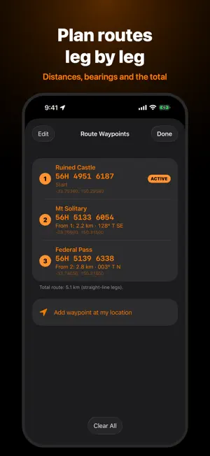
Bush Grid turns 6-digit RFS-style grid references into a place on the map, and tells you how far away it is and which way to go. Built by a volunteer firefighter, for volunteers. Type or paste a reference like 343 509 and Bush Grid drops a marker in the centre of that 100 m square, using the match nearest your GPS position. Add the zone and 100 km square, or paste a full MGA reference, to place it exactly anywhere in the world. GRID REFERENCES • 6-digit (100 m) and 8-digit (10 m) references • Full MGA / UTM references, entered or pasted • Your own position as a live map reference • Grid overlay with labelled grid lines • Long-press anywhere on the map to get its reference ROUTES • Build a route of waypoints by reference or by long-pressing the map • Plan mode shows distance and bearing for each leg of the route • Follow mode shows distance and bearing from where you are now • True or magnetic bearings, metric or imperial • Name, reorder and save waypoints TRIANGULATION • Enter bearings taken from two or more points to locate a smoke or target • See where the bearing lines cross, plus an estimated position and spread • Navigate straight to the estimate BUILT FOR THE FIELD • Dark, high-contrast design with large friendly controls • Grid conversion, distance and bearing work without mobile data • No ads, no account, no tracking: your locations stay on your device BUSH GRID SUPPORTER (optional) Everything above is free, always. Supporters help cover the costs of running Bush Grid and unlock: • Lock Screen and Dynamic Island display of distance and bearing, with previous/next waypoint buttons • Apple Watch app with its own compass arrow and waypoint stepping • Track log with GPX export for incident logs and handovers • Triangulation error cones showing where the target could be Choose a yearly subscription or a one-off lifetime unlock. Tips are also welcome and don't unlock anything. The subscription renews automatically unless cancelled at least 24 hours before the end of the current period; manage it in Settings › Apple Account › Subscriptions. IMPORTANT SAFETY NOTICE Bush Grid is an unofficial convenience aid. It is NOT a primary, certified or emergency navigation system, and it must never be relied on in any emergency or life-safety situation. GPS, compass, grid conversion and map data can all be wrong or unavailable, and a 6-digit reference repeats every 100 km. Always carry and use official maps, a compass and radio, follow your agency's procedures, and verify every location independently. In an emergency, call Triple Zero (000). Bush Grid is independent and is not made, endorsed or supported by the NSW Rural Fire Service or any emergency service or government agency. Use of the app is subject to the End User Licence Agreement shown in the app. Map imagery is provided by Apple Maps and may need a data connection.
App privacy
The developer, Bryan Nouwens, reported these privacy practices to Apple.
Data Not Collected
The developer does not collect any data from this app.
Alternatives to BushGrid
Looking for apps like BushGrid? Here are 5 similar apps on the App Store. The highest rated is Opensignal Speed Test Ad Free (4.5/5), and all 5 are free to download.


| App | Rating | Price | Last updated | Compare |
|---|---|---|---|---|
| BushGrid | – | Free | October 8, 2026 | |
| RFSPager | – | Free | Oct 24, 2026 | Compare |
| RFS ACTIV | – | Free | Sep 28, 2026 | Compare |
| MyAussie | 4.1 / 5 (8) | Free | Oct 20, 2026 | Compare |
| Everyday Mobile (Woolworths) | 2.9 / 5 (21) | Free | Sep 30, 2026 | Compare |
| Opensignal Speed Test Ad Free | 4.5 / 5 (17,887) | Free | Oct 15, 2026 | Compare |
Compare BushGrid with the top alternatives: ratings, updates, ASO score and keyword gaps →