

MarinePath
Mikalai Holub Sports iPhoneiPadiPod touchApple Watch
MarinePath is a free Sports app for iPhone and iPad by Mikalai Holub. Rated 5.0/5 from 2 ratings. Requires iOS 26.0. Updated October 26, 2026.
- Rating
- 5.0
- 2 ratings
- Price
- Free
- on the App Store
- Size
- 17 MB
- Age 4+
- Updated
- Oct 26
- 2026 · v1.5
Screenshots


About MarinePath
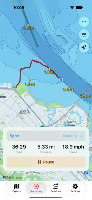
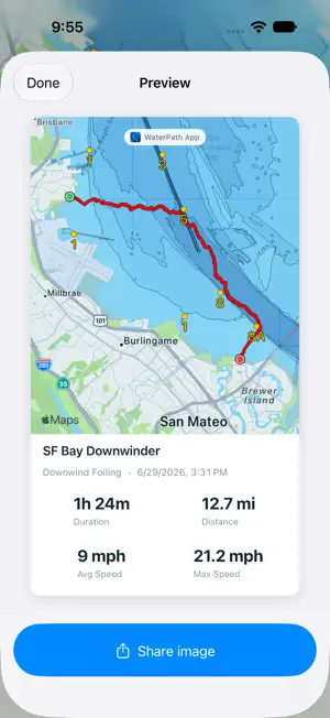
MarinePath brings marine maps, GPS recording and water-sport session tracking to Apple Watch and iPhone. Explore the water, record your track, review your progress and share your adventures. Built for wing foiling, parawing, downwinders, kitesurfing, windsurfing, sailing, kayaking, paddling and other water sports, MarinePath keeps your track and location at the center of the experience. EXPLORE MARINE MAPS See your location on the map, explore nearby waters and find places on iPhone with map search. Switch between Standard and Satellite maps to explore coastlines, bays, rivers and launch spots. Keep marine maps close at hand on Apple Watch while you are on the water. SAVE WAYPOINTS AND FIND YOUR WAY Save waypoints for launch spots, exits and other places you want to find again. View channel markers where available and see distances to help understand where you are relative to familiar points on the water. RECORD ON APPLE WATCH OR IPHONE Record GPS sessions on Apple Watch and review them on iPhone after syncing. You can also record directly on iPhone, with your live track, elapsed time, distance and speed on the map. Choose your sport, pause and resume your session, and open the saved track and statistics when you finish. REVIEW YOUR TRACKS AND STATISTICS Explore saved tracks and see distance, duration, average speed and maximum speed. Use the optional speed-colored track to see how your speed changed along the track. Review average and maximum heart rate when recorded and Heart Rate Stats is enabled. Rename a session or update its sport to keep your session history organized. IMPORT AND EXPORT GPX TRACKS Import recorded GPX tracks with timestamps from Files on iPhone, or export your sessions as GPX to use with other compatible tools. Try the built-in Sample Track to explore the session map and statistics before recording your own outing. SHARE YOUR SESSION Turn a saved session into a portrait image featuring its full track map, session name, sport, date and statistics. Shared images use your session map settings and can include recorded heart-rate statistics when enabled. Save an image to Photos or share it with friends, group chats and other apps through the iPhone share sheet. EXPLORE NOAA MARINE DETAILS View NOAA chart details, navigation markers and optional depth soundings where NOAA provides coverage in U.S. waters. Display depth labels in feet or meters. Depth labels show charted soundings, not live water depth. Outside NOAA coverage, the base map and GPS recording remain useful. No account or sign-in is required. An internet connection is needed to download new map data; previously loaded content may be available from cache. MarinePath supports situational awareness and recreational tracking. It is not a replacement for official nautical charts, approved navigation equipment, emergency services or safe judgment on the water. Map data includes OpenStreetMap contributors and NOAA; no provider endorsement is implied.
What’s new
Version 1.5 · Updated October 26, 2026
- Share a session with an image featuring its full track, name, sport, date and statistics. Save it to Photos or share it with other apps. - Shared images use your session map settings and include recorded heart rate when available and enabled. - Keep separate, remembered map styles and layer settings for Sessions and Explore. Toggle Water Depths directly from the session menu. - Enjoy clearer session statistics, change a saved session's sport, and switch between Standard and Satellite maps with one tap.
App privacy
The developer, Mikalai Holub, reported these privacy practices to Apple.
Data Linked to You
The following data, which may be collected and linked to your identity, may be used for the following purposes:
- Location: Coarse Location
- Diagnostics: Other Diagnostic Data
Used for: App Functionality
Alternatives to MarinePath
Looking for apps like MarinePath? Here are 6 similar apps on the App Store. The highest rated is Foil Run (5.0/5), and all 6 are free to download.
-
 Foil Run
5.0
-
 DriftCrew
5.0
-
 Stoke Log
4.3
-
 foilr - water sport tracker
-
 FanZone Scoreboards
-
 Venturi: Surf, Foil & Wind
5.0
| App | Rating | Price | Last updated | Compare |
|---|---|---|---|---|
| MarinePath | 5.0 / 5 (2 ratings) | Free | October 26, 2026 | |
| Foil Run | 5.0 / 5 (1) | Free | Oct 25, 2026 | Compare |
| DriftCrew | 5.0 / 5 (3) | Free | Oct 22, 2026 | Compare |
| Stoke Log | 4.3 / 5 (3) | Free | May 7, 2024 | Compare |
| foilr - water sport tracker | – | Free | Mar 30, 2025 | Compare |
| FanZone Scoreboards | – | Free | Oct 26, 2026 | Compare |
| Venturi: Surf, Foil & Wind | 5.0 / 5 (61) | Free | Oct 27, 2026 | Compare |
Compare MarinePath with the top alternatives: ratings, updates, ASO score and keyword gaps →