

Darkspot: Light Pollution Map
Nadi Mertan Weather iPhoneiPadiPod touch
Darkspot: Light Pollution Map is a free Weather app for iPhone and iPad by Nadi Mertan. Requires iOS 18.0. Updated October 27, 2026.
- Price
- Free
- on the App Store
- Size
- 3 MB
- Age 4+
- Updated
- Oct 27
- 2026 · v1.0
Screenshots
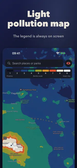


About Darkspot: Light Pollution Map
How dark is the sky where you are, and is tonight worth going out? Darkspot answers both. It reads your sky from 2025 NASA satellite data and shows it on the Bortle scale, from 1 (pristine) to 9 (inner city), with what you'll actually see: the Milky Way with detail, only overhead, or not at all. Tonight, with reasons Every night gets a plain score (Great, Good, Fair, Poor or Not tonight) and the reasons behind it: when the moon sets, whether the clouds clear, when the Milky Way core is up. Darkness, moon and twilight are worked out on your phone; cloud cover comes from Apple Weather. The week view picks the best night for you. A light pollution map with its legend The whole contiguous US, coloured by Bortle class, with the scale always on screen. Tap anywhere to see how dark it is and tonight's window there. The darkness data lives on your phone, so the Bortle lookup works with no signal. Find darker skies From any place, Darkspot finds the nearest parks and campgrounds under a darker sky, with drive times from Apple Maps and tonight's score at each. One tap hands off to Maps. Save spots and get great-night alerts Save your backyard and your favourite dark sites to compare them at a glance. Turn on the bell and Darkspot tells you when a great night is coming in the next 72 hours. It's worked out on your phone: no account, no server. Red mode for your night vision One tap turns every screen deep red, with no white or blue light, so your eyes stay dark-adapted at the telescope. Honest about accuracy Checked against 286 National Park Service sky measurements the model was never tuned on: half were within 0.21 mag/arcsec² of what Darkspot predicts, typically within about one Bortle class. Nearby lights such as a porch light or a parking lot aren't in the model. Free, private, no account Your own location, the forecast, saved spots and alerts are all free. No ads, no tracking, no sign-up. Your location goes only to Apple Weather and Apple Maps, never to us. Darkness data covers the contiguous United States. Tonight's moon, darkness window and clouds work anywhere.
App privacy
The developer, Nadi Mertan, reported these privacy practices to Apple.
Data Not Collected
The developer does not collect any data from this app.
Alternatives to Darkspot: Light Pollution Map
Looking for apps like Darkspot: Light Pollution Map? Here are 6 similar apps on the App Store. The highest rated is Sun Quest: Seeker & Tracker (4.8/5), and all 6 are free to download.
-
 Drone Spot – Forecast and Map
4.0
-
 KuwaitMet
3.5
-
 Light Pollution Map - Dark Sky
4.5
-
 Sun Quest: Seeker & Tracker
4.8
-
 Rain Maps
4.1
-
 Stargazing Hub - Sky Live
4.8
| App | Rating | Price | Last updated | Compare |
|---|---|---|---|---|
| Darkspot: Light Pollution Map | – | Free | October 27, 2026 | |
| Drone Spot – Forecast and Map | 4.0 / 5 (7) | Free | Oct 15, 2026 | Compare |
| KuwaitMet | 3.5 / 5 (138) | Free | Aug 18, 2025 | Compare |
| Light Pollution Map - Dark Sky | 4.5 / 5 (251) | Free | Sep 28, 2026 | Compare |
| Sun Quest: Seeker & Tracker | 4.8 / 5 (741) | Free | Oct 23, 2026 | Compare |
| Rain Maps | 4.1 / 5 (84) | Free | Oct 19, 2026 | Compare |
| Stargazing Hub - Sky Live | 4.8 / 5 (46) | Free | Oct 28, 2026 | Compare |