

AboveSea: Elevation Map
Vitalii Fastovets Navigation iPhoneiPadiPod touch
AboveSea: Elevation Map is a free Navigation app for iPhone and iPad by Vitalii Fastovets. Requires iOS 17.0. Updated October 12, 2026.
- Price
- Free
- on the App Store
- Size
- 31 MB
- Age 4+
- Updated
- Oct 12
- 2026 · v1.0.1
Screenshots

About AboveSea: Elevation Map
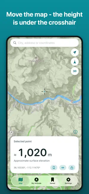
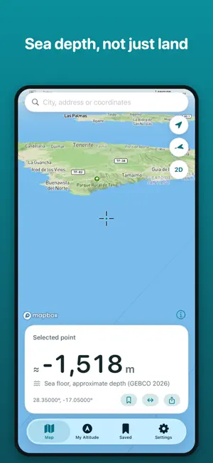
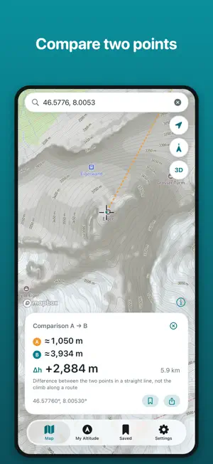
Explore approximate terrain elevation above sea level and the depth of seas and oceans. Move the map: the number under the crosshair shows the elevation of the selected point on land or the depth of the sea floor. FEATURES • Terrain elevation and sea depths on the map • Mountains and valleys in 3D • Compare two points: elevation difference and straight-line distance • Search for cities, addresses and coordinates, including degrees, minutes and seconds • View your current altitude from iPhone location services on a separate screen • Save your own places on your iPhone • Meters or feet, light or dark appearance DATA ACCURACY Map elevation comes from a terrain model; sea depths come from bathymetric data. Values are approximate. When zoomed out, values are rounded or the app asks you to zoom in. Narrow summits may be smoothed in the model. Your current altitude from location services is shown separately and can differ from the surface elevation, for example on a bridge or on an upper floor of a building. PRIVACY No registration or advertising. Saved places stay on your iPhone. You can browse the map without granting location access. AboveSea is a reference tool. Do not use it as a surveying instrument, an aviation altimeter or a tool for emergency navigation. Map data © Mapbox © OpenStreetMap contributors. Sea depths: GEBCO Compilation Group (2026) GEBCO 2026 Grid.
What’s new
Version 1.0.1 · Updated October 12, 2026
• The map opens at your current location if you allow location access. • Search by coordinates in degrees, minutes and seconds. • Cities near the area on the map come first in search; worldwide search still works. • Copy coordinates or open the selected point in Apple Maps. • More reliable saving of places and a fix for distance calculation. • Clearer explanations of terrain elevation, sea depth and your current altitude.
App privacy
The developer, Vitalii Fastovets, reported these privacy practices to Apple.
Data Linked to You
The following data, which may be collected and linked to your identity, may be used for the following purposes:
- Location: Precise Location
- Diagnostics: Other Diagnostic Data
- Contact Info: Email Address
- User Content: Customer Support
Used for: Analytics, App Functionality
Data Not Linked to You
The following data, which may be collected but is not linked to your identity, may be used for the following purposes:
- Location: Coarse Location
- Identifiers: User ID
- Usage Data: Product Interaction, Other Usage Data
- Diagnostics: Performance Data
- Search History: Search History
Used for: Analytics, App Functionality
Alternatives to AboveSea: Elevation Map
Looking for apps like AboveSea: Elevation Map? Here are 6 similar apps on the App Store.


| App | Rating | Price | Last updated | Compare |
|---|---|---|---|---|
| AboveSea: Elevation Map | – | Free | October 12, 2026 | |
| Altimeter Tracker | – | Free | Sep 25, 2026 | Compare |
| Zero Meter | – | Free | May 27, 2026 | Compare |
| Mini Altimeter | – | Free | Sep 14, 2026 | Compare |
| Autonav Go | – | Free | Sep 16, 2026 | Compare |
| Depthly - Sea Depth | – | Free | Aug 26, 2026 | Compare |
| BoatConnect App | – | Free | Jun 30, 2026 | Compare |