

Geodeo: Rockhounding Spots Map
Michael Glazebrook Navigation iPhoneiPadiPod touch
Geodeo: Rockhounding Spots Map is a free Navigation app for iPhone and iPad by Michael Glazebrook. Rated 1.0/5 from 1 ratings. Requires iOS 16.4.
- Rating
- 1.0
- 1 ratings
- Price
- Free
- on the App Store
- Size
- 74 MB
- Age 4+
- Updated
- Oct 21
- 2026 · v1.0.6
Screenshots



About Geodeo: Rockhounding Spots Map
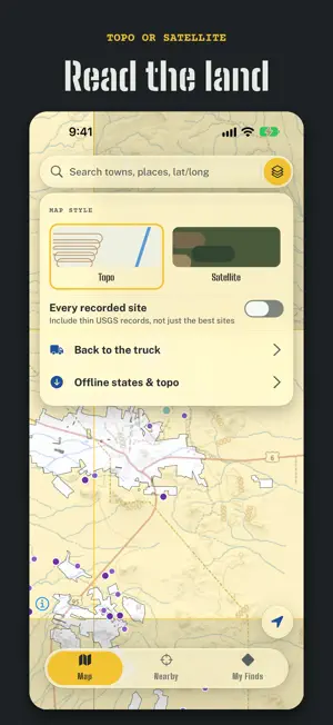
Is this rock yours to take? Tap the spot on the map and Geodeo stamps the answer: open to collect, hand tools only, claimed, closed, private, or check local rules. It reads the same public land records a field office uses, in all 50 states, on your phone past the last bar of signal. KNOW BEFORE YOU DIG • Land ownership in every state, public land green and private orange, with buttons to hide either. • Nearest open land: one tap finds the closest BLM or forest ground that reads open to collect, even in another state. Zoomed out, darker green marks where open land is deepest, and Open land by state ranks them. • National parks, monuments, wildlife refuges and wilderness from the USGS protected-areas database, with the reason collecting is barred or limited. • Active lode and placer mining claims across the western states, refreshed weekly from BLM's claim records and checked in every verdict, so you don't pick up someone else's mineral. • State-specific rules where a state writes its own, such as Iowa's ban on removing rocks from state parks. • The rule that applies, with its citation: casual-use limits, the 25 lb daily and 250 lb yearly petrified wood allowance, the vertebrate fossil permit rule. SITES WORTH THE DRIVE Geodeo starts from the USGS mineral records and throws out gravel pits, quarries and processing plants, then ranks what's left by how collectible it is. Sites on private ground stay hidden unless asked for. Hand-checked public spots, like the fossil quarry at Iowa's Fossil & Prairie Park, carry their own rules and a link to the managing agency. FIND ANY TOWN, EVEN OFFLINE Search 30,000 towns, any state, or a latitude and longitude. With a signal the map reads the land anywhere; save a state from the map to carry it offline. EVERY FIND EARNS A LABEL Log what you found and it becomes a numbered specimen with a museum-style label: hardness, luster, streak, crystal system and locality by USGS quadrangle. A curator grade from A to D rewards documenting it well, not finding something rare. • Scratch test: a fingernail, a penny, a knife or a quartz point. Each answer halves the hardness range, and likely minerals rank by what the records list nearby. • Crack the geode: photograph the outside and the inside, then press and hold until it splits open on screen. DIG DOWN THROUGH TIME Your finds build a stratigraphic column that descends through the real geologic time scale, in the international chart's own colors. A photo of a specimen left where it lay counts the same as keeping it. Walk a find into an unsurveyed 7.5-minute quad and it clears from the map. FIELD BRIEFS Three real sites within about 50 miles, each on open land, and no clock on any of them. BACK TO THE TRUCK Pin where you parked and a compass arrow leads you back. FREE, WITH NO ADS The verdict at any spot in any state, the mineral sites, one state saved offline, one offline topo area and every part of the geology game are free. GEODEO PRO • Claimed ground drawn on the map, plus claim records at any spot: serial number, status, acreage and last update from BLM. • Every state offline, plus unlimited saved topo areas. • Export your finds as GPX or CSV, and print specimen label sheets. Pro costs $24.99 a year or $4.99 a month, and either plan starts with 7 free days. Both keep renewing until you turn them off, at least one full day ahead of the next billing date; turn them off from the Subscriptions page of your Apple ID. Your finds, photos and truck pin stay on your phone. Land lines are only accurate to roughly 100 m and records can lag; posted signs, local closures and forest orders always win, so confirm with the managing office before you collect. Never enter an old mine opening. Terms of Use (EULA): https://www.apple.com/legal/internet-services/itunes/dev/stdeula/ Privacy Policy: https://app-factory-privacy-policy.vercel.app
What’s new
Version 1.0.6 · Updated October 21, 2026
Know before you dig: the verdict and the land map stay free at every spot you check. When Geodeo offers its free week of Pro, it now says up front that nothing you already use gets locked, and Not now closes it in one tap.
App privacy
The developer, Michael Glazebrook, reported these privacy practices to Apple.
Data Linked to You
The following data, which may be collected and linked to your identity, may be used for the following purposes:
- Usage Data: Advertising Data
Used for: Analytics
Data Not Linked to You
The following data, which may be collected but is not linked to your identity, may be used for the following purposes:
- Usage Data: Product Interaction
- Purchases: Purchase History
Used for: Analytics, App Functionality
Alternatives to Geodeo: Rockhounding Spots Map
Looking for apps like Geodeo: Rockhounding Spots Map? Here are 6 similar apps on the App Store. The highest rated is Rockhounding.org (5.0/5), and all 6 are free to download.
-
 Rockhounding.org
5.0
-
 Orecast: Minerals & Fossils
5.0
-
 Gold Prospector App
5.0
-
 Ablegrid Platform
-
 RockHoundR: Rockhounding Map
4.6
-
 Puerto Rico Ferry
5.0
| App | Rating | Price | Last updated | Compare |
|---|---|---|---|---|
| Geodeo: Rockhounding Spots Map | 1.0 / 5 (1 rating) | Free | October 21, 2026 | |
| Rockhounding.org | 5.0 / 5 (4) | Free | Oct 11, 2026 | Compare |
| Orecast: Minerals & Fossils | 5.0 / 5 (1) | Free | Oct 11, 2026 | Compare |
| Gold Prospector App | 5.0 / 5 (6) | Free | Oct 17, 2026 | Compare |
| Ablegrid Platform | – | Free | Nov 6, 2024 | Compare |
| RockHoundR: Rockhounding Map | 4.6 / 5 (136) | Free | Oct 10, 2026 | Compare |
| Puerto Rico Ferry | 5.0 / 5 (2) | Free | Oct 29, 2025 | Compare |