

Almighty: World Tracker
Bonny James Education iPhoneiPadiPod touch
Almighty: World Tracker is a free Education app for iPhone and iPad by Bonny James. Requires iOS 16.4. Updated October 15, 2026.
- Price
- Free
- on the App Store
- Size
- 87 MB
- Age 17+
- Updated
- Oct 15
- 2026 · v1.0.5
Screenshots


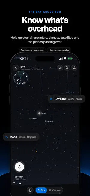

About Almighty: World Tracker
Almighty is a real-time geospatial observatory: open aeronautical, orbital, geophysical and meteorological data streams, fused into one explorable 3D globe. Aircraft transponders, published orbital elements, seismic networks, satellite thermal sensors and numerical weather models already describe the state of the planet minute by minute. Almighty resolves them into a single Earth-fixed frame and lets you interrogate it by touch or by voice. AVIATION • Live traffic: ADS-B positions from a community receiver network, advanced between reports by dead reckoning, so aircraft move continuously instead of jumping. • Target tracking: select any aircraft and the camera locks on, drawing the track flown since take-off and a short projected path, with callsign, type, altitude, ground speed and heading. • Chase and cockpit views: per-class 3D aircraft models flown over 3D terrain, seen from behind or from the flight deck. • Airports: arrivals, departures and aircraft on the ground, with the latest METAR observation. • Watchlist: save flights and be alerted to take-off and landing while the app is open. ORBITAL AND DEEP SPACE • Satellites: CelesTrak element sets propagated on the device with the SGP4 model, colour-coded by class, from crewed stations to navigation and weather constellations. • Solar System: planets, moons, asteroids and active spacecraft on a time axis, with spacecraft ephemerides from NASA JPL Horizons. • Missions: Voyager 1, Cassini, Perseverance, Apollo 11 and more, each placed where it happened. • Surface exploration: the Moon, Mars and the planets in 3D, with landing sites and named features. THE SKY ABOVE YOU • Celestial sphere: 9,096 naked-eye stars from the Yale Bright Star Catalogue, constellation figures and the Milky Way; the Sun, the Moon (in its true phase) and the planets computed on the device. • Augmented reality: compass and gyroscope orient the view, corrected for magnetic declination with the World Magnetic Model 2025, optionally over the live camera image, which never leaves the phone. • Overhead traffic: aircraft within about 90 km plotted at their true bearing and elevation, with a heading-locked radar. EARTH SYSTEM • Seismicity: earthquakes from the US Geological Survey's real-time feeds, clustered at global scale. • Wildfire: active-fire detections from VIIRS thermal sensors via NASA FIRMS. • Tropical cyclones: active storms from NOAA National Hurricane Center advisories. • Atmosphere: GOES and Himawari infrared cloud imagery and IMERG precipitation via NASA GIBS; 48-hour MET Norway forecasts of temperature, wind, precipitation, cloud, humidity and pressure. EVENTS AND INFRASTRUCTURE • News: major world events, disasters and breaking stories, geolocated from the GDELT event database, each linked to the original publisher. • Roads: live UK road incidents from Transport for London and national road authorities, and London traffic cameras. INTERFACE • Voice: hold to speak ("fly to Tokyo", "follow the ISS"). Apple speech recognition, most commands resolved on the device, and an optional language-model fallback that asks permission before first use. • Offline search: cities, countries, airports and raw coordinates resolved from a bundled gazetteer, with no network request. • Cartography: Clean, Satellite (Landsat detail), Today, Night lights (NASA Black Marble) and Classic styles, on a 3D globe with terrain or a flat projection. No account. No advertising. No cross-app tracking. Scope and limitations: every source is public or openly licensed and credited in the app. Live feeds can be delayed or incomplete; Almighty is an instrument for curiosity and study, not for navigation or safety-critical decisions. It observes public objects and events, never individuals: aircraft whose owners have requested privacy are excluded. Terms of Use: https://almighty-site.pages.dev/terms.html Privacy Policy: https://almighty-site.pages.dev/privacy.html
What’s new
Version 1.0.5 · Updated October 15, 2026
Version 1.0.5: rendering fidelity, efficiency and live observation This release refines rendering fidelity and computational efficiency. The night-lights view now follows the instantaneous solar terminator: NASA's Black Marble emission is masked per pixel by solar elevation, so the luminous signature of the world's cities appears only where night has actually fallen, with civil twilight rendered as a continuous transition. New layers present official live streams (including hydrophones, and research-vessel dives that track the ship's position), the Deep Space Network's current antenna contacts, and charted shipwrecks. A followed aircraft gains greater perceptual salience through contour highlighting and a peripheral luminance gradient; on capable devices an optional depth-of-field effect is available. Terrain at regional scales is hill-shaded. Start-up payload is reduced by approximately 355 kB, an adaptive data-saving mode responds to constrained networks (including iOS Low Data Mode), and the Solar System, Milky Way and sky views render on demand, reducing energy use at rest. Also in this update (from version 1.0.4): Earth sciences, curated open data and historical reconstruction An "Earth & hazards" suite grounded in peer-reviewed geophysical models. A pole-to-pole cut-away renders the planet's internal stratification (crust, upper and lower mantle, liquid outer core and solid inner core) at depths from the Preliminary Reference Earth Model (Dziewonski & Anderson, 1981). Within it, some 23,500 earthquakes of magnitude 5.5 and above recorded by the USGS since 1976 are plotted at their hypocentral depths, revealing subducting slabs beneath Japan, Tonga and the Andes. Plate boundaries follow Bird's PB2002 model (2003), classified by tectonic regime, with subduction polarity indicated and plate velocities resolved in a no-net-rotation frame; the Ring of Fire may be highlighted. Ocean-crust age derives from Müller et al. (2008). Hotspot tracks such as the Hawaiian–Emperor chain are annotated with radiometric ages. The geomagnetic field is modelled as an IGRF-14 dipole, alongside the secular migration of the magnetic poles since 1590. A palaeogeographic reconstruction (Müller et al., 2019) lets you step through 250 million years of continental drift, from Pangaea to the present day. The solar terminator is drawn with its civil, nautical and astronomical twilights. A new History category offers an animated reconstruction of RMS Titanic's maiden voyage, among other moments from the past, placed where they happened. Newly available layers: submarine cable networks, AI computing infrastructure, airport meteorological reports (METAR, winds in knots), space-based lightning detection, armed conflicts (drawn on internationally recognised borders and described in neutral terms), official weather warnings, power stations (with post-2021 changes noted), GNSS interference and global disaster alerts. The Layers panel is now organised into searchable thematic groups. Navigating to your own location is immediate and no longer momentarily loses the globe on arrival, and multi-stop flights now display the correct leg of their journey. All sources are credited in Data & Credits.
App privacy
The developer, Bonny James, reported these privacy practices to Apple.
Data Used to Track You
The following data may be used to track you across apps and websites owned by other companies:
- Location: Coarse Location
Data Linked to You
The following data, which may be collected and linked to your identity, may be used for the following purposes:
- Location: Coarse Location
- User Content: Other User Content
- Identifiers: User ID
- Usage Data: Product Interaction
Used for: Third-Party Advertising, App Functionality
Data Not Linked to You
The following data, which may be collected but is not linked to your identity, may be used for the following purposes:
- Usage Data: Product Interaction
Used for: Third-Party Advertising, Analytics
Alternatives to Almighty: World Tracker
Looking for apps like Almighty: World Tracker? Here are 6 similar apps on the App Store. The highest rated is PlanetEar: God's Eye View (4.8/5), and all 6 are free to download.
-
 SlicedBody
-
 Star Map Night Sky - SpaceUtil
-
 Horizon-AR
-
 PlanetEar: God's Eye View
4.8
-
 Deep Time Walk: Earth History
4.5
-
 Space Museum: Spacecraft in 3D
3.6
| App | Rating | Price | Last updated | Compare |
|---|---|---|---|---|
| Almighty: World Tracker | – | Free | October 15, 2026 | |
| SlicedBody | – | Free | Sep 18, 2026 | Compare |
| Star Map Night Sky - SpaceUtil | – | Free | Oct 16, 2026 | Compare |
| Horizon-AR | – | Free | Aug 26, 2026 | Compare |
| PlanetEar: God's Eye View | 4.8 / 5 (26) | Free | Oct 16, 2026 | Compare |
| Deep Time Walk: Earth History | 4.5 / 5 (33) | Free | Aug 21, 2026 | Compare |
| Space Museum: Spacecraft in 3D | 3.6 / 5 (30) | Free | May 12, 2026 | Compare |