

Bitegrid: Fish Forecast & Map
Upswing Projects LLC Sports iPhoneiPadiPod touch
Bitegrid: Fish Forecast & Map is a free Sports app for iPhone and iPad by Upswing Projects LLC. Rated 5.0/5 from 3 ratings. Requires iOS 15.0.
- Rating
- 5.0
- 3 ratings
- Price
- Free
- on the App Store
- Size
- 56 MB
- Age 4+
- Updated
- Oct 21
- 2026 · v1.2
Screenshots



About Bitegrid: Fish Forecast & Map
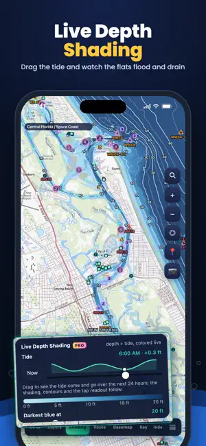
Know WHEN they'll bite and see exactly where! BiteGrid rolls tide, moon, pressure, light and wind into one hourly Bite Score out of 25 for the fish you're after. See WHERE Ocean and intercoastal depths that change with the tide, plus charted wrecks and reefs. BiteGrid automatically finds and rates thousands of fishing spots along Florida's coast. Plan your route from the ramp, join or host a tournament, keep a PRIVATE log of every catch. Everything you need to get on the water faster Our AI fishing spots read the bottom, tide and current, and fish habitat like seagrass and oyster beds, and were tested against 7.2 MILLION fish caught and counted in Florida's fish surveys since 1996. Built for Florida, Pensacola to the Keys. Live Depth Shading and NOAA tides also cover the rest of the US Atlantic, Gulf and Pacific coasts. THE BITE SCORE • One score for every hour, built from tide and current, light, wind, moon and solunar, pressure and water temperature • Pick your fish: 20 saltwater species, from snook, redfish and seatrout to tarpon, kingfish and sailfish • Tap any hour to see why it scored the way it did • NOAA tides and National Weather Service marine alerts built in LIVE DEPTH SHADING • Depth shading from NOAA surveys and lidar, colored for the tide right now • Drag the tide slider and watch the flats drain and flood over the next 24 hours • Contour lines down to 1 ft, bottom relief and satellite imagery FIND THE SPOTS • AI Spots (beta) rate holes, edges and creek mouths for the species you pick • Charted reefs, wrecks and rocks from NOAA • Drop pins, save your spots and check the depth right now anywhere you tap PLAN THE RUN • Water routes from the ramp to your spot, with distance and time for your boat or kayak • FWC manatee and speed zones on the chart and in every route • Save areas for offline use on days with no signal LOG EVERY CATCH • Photos, length and weight, records, slams and trophies, kept on your phone • FWC seasons and size limits at a glance, for reference TOURNAMENT MODE • Host or join with a code: fishing area, rules, photo judging and a live leaderboard Light by day, dark by night. No ads, no sign-up.
What’s new
Version 1.2 · Updated October 21, 2026
AI Spots, improvements: the phone finds the spots itself in Live Depth Shading: holes, bars, drop-offs, channel edges, troughs, creek mouths and shorelines with depth; each is rated 1–5 stars, with shore type and nearby seagrass and oyster beds counted in; the card shows depth now, why it’s a spot, what high and low tide do there, fish and bait, and Route here; long-press the chip to filter spots, and markers carry a star badge, with top spots glowing. Trip planning: trip times from the spot card, and a beach start for paddlers; NOAA tidal current in trip times where a station is near; a 3 ft safety line while you plan, routes that never cross land, and Clear route. Reefs and wrecks: FWC artificial-reef cards, and wreck, rock and obstruction cards from NOAA’s chart. Tournaments: several ways to win, a Champion trophy, rejoin by code, and End/Cancel for organizers. Catch Log: all 28 fish in the collection have pictures. Map: faster and smoother, zooms out to the whole US, offline areas offer depth-shading updates, and shading stays steady on slow connections. It also gets a simpler depth card, night speed limits that switch at sunset.
App privacy
The developer, Upswing Projects LLC, reported these privacy practices to Apple.
Data Not Linked to You
The following data, which may be collected but is not linked to your identity, may be used for the following purposes:
- Location: Coarse Location
Used for: App Functionality