

Slack Water – Port Phillip
GanSoft SARL Weather iPhoneiPadiPod touch
Slack Water – Port Phillip is a free Weather app for iPhone and iPad by GanSoft SARL. Requires iOS 15.0. Updated October 16, 2026.
- Price
- Free
- on the App Store
- Size
- 25 MB
- Age 4+
- Updated
- Oct 16
- 2026 · v1.2.0
Screenshots

About Slack Water – Port Phillip
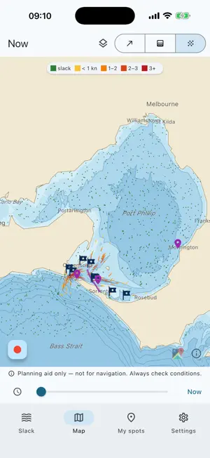
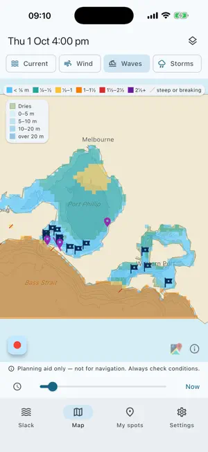
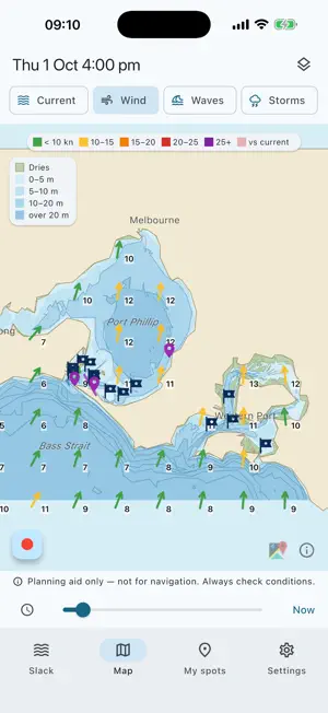
Slack water times and a tidal current map for Port Phillip — the Rip, the Heads and the southern Bay — and Western Port. And now the next 48 hours of wind, gusts, storm risk and waves, worked out with the current. Through the Heads the tide runs at four knots and more, and slack lasts minutes. It turns at a different time at every site, and the run-in and run-out don't behave the same. Slack Water works it out site by site, on your phone, with no reception needed. SLACK TIMES, SITE BY SITE Port Phillip: the Rip, Lonsdale Wall, Pope's Eye, Portsea Hole, the Hurricane wreck, Portsea, Queenscliff, Blairgowrie and Rye piers. Western Port: the Western Entrance, Cowes and Stony Point jetties, the Corinella channel, San Remo bridge and jetty. See the turn, and the window when the current stays under your own limit. CURRENT MAP OF BOTH BAYS See where it's running and where it's slack: arrows, a colour map by speed, or animated flow. YOUR OWN SPOTS AND TRACKS Drop your marks on the map or where you stand, with a note and a date (depth, bait, what you caught), or open a GPX file from your plotter, email or Files and pick the ones you want. Current and slack at each one. Hide spots from the map or keep only the ones you follow in the slack list. Record your track on the water and export it as GPX. BUILT-IN MAP OF BOTH BAYS Depth shading, contours every 5 m and, if you want it, the seabed type (sand, mud, seagrass, reef) and the banks that dry at low tide. All on your phone. WIND, WAVES AND STORMS — NEXT 48 HOURS Wind and gusts on the map and at every site. Waves in both bays and at the Rip, computed on your phone from the wind, the fetch, the depth, the tide and the current: wind against the ebb at the Heads builds a short, steep sea, and the map shows it. Storm risk from the atmosphere's instability. Checked against the five wave buoys in Port Phillip. SLACK AND WIND-AGAINST-CURRENT ALERTS Get a heads-up before slack at the sites you pick, and when 10 knots of wind or more will blow against the current. You choose how early. MELBOURNE TIME, ALWAYS Times are shown in Melbourne time, daylight saving included. MADE FOR Fishos, scuba divers, freedivers, snorkellers, kayakers and sailors crossing the Rip. FREE • Current right now, anywhere in Port Phillip and Western Port • Next slack at every site and spot • Your spots and GPX import/export CURRENTS (PLAN AHEAD) — YEARLY SUBSCRIPTION • Any day, any time: plan tomorrow's trip tonight • Full-day current curve and every slack window • Three-day current map • Slack alerts COMPLETE — YEARLY SUBSCRIPTION Everything in Currents, plus the next 48 hours of: • Wind and gusts, on the map and at every site • Waves in both bays and at the Rip, with the current • Storm risk • Wind-against-current alerts from 10 knots Both plans start with a 7-day free trial for new subscribers: cancel at least 24 hours before it ends and you are not charged. Subscriptions renew every year unless cancelled at least 24 hours before the end of the period. Manage or cancel it in your App Store account settings. PLANNING AID ONLY — NOT FOR NAVIGATION Current predictions are astronomical tide only (no wind, swell, rain or river flow), from simplified models of each bay, averaged over the depth; times are approximate. Wind, gusts, storm risk and offshore swell come from the NOAA GFS global model (25 km): local effects such as sea breezes are not resolved, and storm risk is not a warning. None of this is official: the references are the Bureau of Meteorology tide tables, marine forecasts and warnings, and AHO charts. Always check conditions on site. Terms: https://gansoft.ch/slackwater-terms.html Privacy: https://gansoft.ch/slackwater-privacy-policy.html Terms of use: https://www.apple.com/legal/internet-services/itunes/dev/stdeula/
What’s new
Version 1.2.0 · Updated October 16, 2026
New: a 7-day free trial on both plans. Add a note and a date to your spots (they also go in your GPX files). Corinella added in Western Port, with a finer model of its channel.
App privacy
The developer, GanSoft SARL, reported these privacy practices to Apple.
Data Not Linked to You
The following data, which may be collected but is not linked to your identity, may be used for the following purposes:
- Purchases: Purchase History
- Location: Coarse Location
- Usage Data: Product Interaction
Used for: Analytics
Alternatives to Slack Water – Port Phillip
Looking for apps like Slack Water – Port Phillip? Here are 6 similar apps on the App Store. The highest rated is Tide Times Australia Plus (5.0/5), and 5 of the 6 are free to download.
-
 Victoria Tide Times
-
 Tide Times Australia Plus
5.0
-
 Gippsland Ports
-
 Water Storages
4.0
-
 Tide Times Australia
4.8
-
 Swell Scope - Surf Forecast
4.9
| App | Rating | Price | Last updated | Compare |
|---|---|---|---|---|
| Slack Water – Port Phillip | – | Free | October 16, 2026 | |
| Victoria Tide Times | – | Free | Aug 10, 2025 | Compare |
| Tide Times Australia Plus | 5.0 / 5 (3) | 1.99 USD | Feb 27, 2025 | Compare |
| Gippsland Ports | – | Free | Sep 17, 2026 | Compare |
| Water Storages | 4.0 / 5 (1) | Free | Sep 2, 2026 | Compare |
| Tide Times Australia | 4.8 / 5 (28) | Free | Apr 25, 2025 | Compare |
| Swell Scope - Surf Forecast | 4.9 / 5 (54) | Free | Oct 17, 2026 | Compare |