

PatrolAxis Navigation
Seven Sipe Navigation iPhoneiPadiPod touchApple Watch
PatrolAxis Navigation is a free Navigation app for iPhone and iPad by Seven Sipe. Rated 5.0/5 from 2 ratings. Requires iOS 17.0. Updated October 21, 2026.
- Rating
- 5.0
- 2 ratings
- Price
- Free
- on the App Store
- Size
- 81 MB
- Age 4+
- Updated
- Oct 21
- 2026 · v1.6.5
Screenshots


About PatrolAxis Navigation
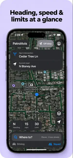
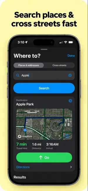
It’s 2026. It’s time to ditch the dusty GPS on your dash. PatrolAxis Navigation brings patrol-focused navigation to your iPhone and CarPlay. It gives you directions, but it also keeps the information you need to describe your location right in front of you: your current road, next cross street, approximate block number, direction of travel, and available speed-limit information. Built first for law enforcement—and useful to fire, EMS, and other first responders—PatrolAxis is designed for the way a shift actually moves. One minute you’re working traffic. The next you’re responding across town, following a changing route during a vehicle pursuit, or moving on foot through an unfamiliar neighborhood. KNOW WHERE YOU ARE • Live Road and Cross-Street Awareness See the road you’re on and the next intersection without searching the map. Keep useful location context visible for radio traffic during patrol, calls for service, and vehicle pursuits. • Block Numbers and Nearby Addresses View an approximate block number and available address information as you travel through residential streets, business districts, and unfamiliar areas. • Direction and Speed Limits See your direction of travel and available posted speed-limit data alongside your road information. • Navigation Built Around Patrol Get turn-by-turn directions while keeping street and intersection details in view. On supported CarPlay vehicles, upcoming turns can also appear in the instrument cluster or head-up display. • On-Foot Awareness Switch to an on-foot view for foot patrols and fast-moving situations. The Apple Watch companion shows road, address, and direction information on your wrist. Hold Address keeps a location visible when you need to relay it. SEE WHAT’S HAPPENING AROUND YOU • State Crash and Incident Maps View available crashes, disabled vehicles, hazards, police activity, closures, and other reports from public highway patrol and transportation feeds. PatrolAxis loads information for your state and switches feeds when you cross a state line. • Traffic and Road Conditions Use traffic colors to spot congestion and see available state-reported work zones and road closures on the map. • Your Jurisdiction, Clearly Marked Choose the city or county you serve and see its boundary outlined in bright red. County agencies can identify cities as included, excluded, mutual aid, or reference only. PatrolAxis can alert you on iPhone and CarPlay when you leave your selected service area. TOOLS FOR THE WHOLE RESPONSE • Hydrants and Water Supply Search available public hydrant data for one city or an entire county. See red hydrant icons, dry hydrants, and draft sites on the map. Tap a location for details its source publishes, such as flow, pressure, connections, status, or test dates. Navigate to a hydrant from your phone or browse nearby hydrants in CarPlay. • Hospitals and Trauma Centers Find and navigate to hospitals, including trauma centers listed in available place data. Save up to six hospitals to Speed Dial for quick access on iPhone and CarPlay. • Landing Zone and Response Pins Drop a pin for a potential landing zone (LZ) or another response location and navigate to it. • More Public Safety Layers Show available fire stations and schools, and tap map features to review their details and sources. CONNECTED THROUGHOUT YOUR SHIFT • CarPlay keeps navigation and enabled public safety information visible in your vehicle. • Apple Watch puts location context on your wrist when you’re away from the car. • Squads let participating personnel share locations, see one another, and use emergency features. • Custom map controls let you choose your style, traffic, zoom, compass, information boxes, and night appearance. Retire the old dashboard GPS. Put a map built for patrol where you can use it. Know your street. Know your direction. Know your location. Terms of Use (EULA): https://www.apple.com/legal/internet-services/itunes/dev/stdeula/
What’s new
Version 1.6.5 · Updated October 21, 2026
Bug Fixes Find a bug or have a suggestion? Check out the Discord and submit your suggestions to developers!
App privacy
The developer, Seven Sipe, reported these privacy practices to Apple.
Data Not Collected
The developer does not collect any data from this app.
Alternatives to PatrolAxis Navigation
Looking for apps like PatrolAxis Navigation? Here are 6 similar apps on the App Store. The highest rated is Location? (5.0/5), and all 6 are free to download.
-
 Location?
5.0
-
 PatrolNav GPS
4.7
-
 Intersector
-
 GPS Live Navigation: Offline
4.6
-
 GridNav - MGRS Land Nav GPS
5.0
-
 Niagara Falls: USA & Canada
3.7
| App | Rating | Price | Last updated | Compare |
|---|---|---|---|---|
| PatrolAxis Navigation | 5.0 / 5 (2 ratings) | Free | October 21, 2026 | |
| Location? | 5.0 / 5 (7) | Free | Oct 1, 2026 | Compare |
| PatrolNav GPS | 4.7 / 5 (42) | Free | Oct 15, 2026 | Compare |
| Intersector | – | Free | Oct 10, 2026 | Compare |
| GPS Live Navigation: Offline | 4.6 / 5 (5) | Free | Sep 12, 2026 | Compare |
| GridNav - MGRS Land Nav GPS | 5.0 / 5 (4) | Free | Sep 14, 2026 | Compare |
| Niagara Falls: USA & Canada | 3.7 / 5 (3) | Free | Oct 8, 2024 | Compare |