

Trig: NZ Topo Maps & Tramping
Bradley Windybank Navigation iPhoneiPadiPod touchApple Watch
Trig: NZ Topo Maps & Tramping is a free Navigation app for iPhone and iPad by Bradley Windybank. Requires iOS 26.4. Updated October 12, 2026.
- Price
- Free
- on the App Store
- Size
- 124 MB
- Age 4+
- Updated
- Oct 12
- 2026 · v1.0
Screenshots


About Trig: NZ Topo Maps & Tramping
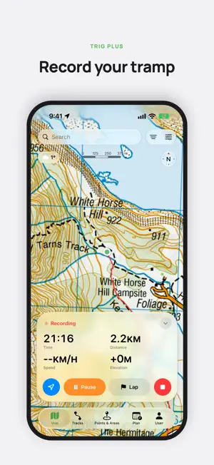
Trig puts New Zealand's official Topo50 maps on your iPhone, iPad and Apple Watch, with every DOC hut, track and campsite, and it all works with no mobile signal. It's a native app built with care. It should feel at home, and work across, all your iOS devices. With so many more features than the rest, great integrations, and it's easy to use. Built by a kiwi, for kiwi. Trig covers New Zealand only. The maps and the hut and track details are for New Zealand. FREE • Topo50 maps for the whole country, with hillshade and slope layers, downloaded to your phone for offline use • Every DOC hut, track, campsite and hunting area, with facilities, alerts and booking links • The Te Araroa trail, tides, and climbing routes from ClimbNZ • Weather for any point on the map, and MetService severe weather alerts • Search for places, peaks, huts and tracks • Export all your data at any time TRIG PLUS • Record tracks with distance, climb and time, even with the screen off • Save your recordings to Apple Health as workouts • Navigate along a track or route, with alerts when you go off course • Draw routes that follow the tracks, with elevation profiles • Find trips that suit your dates, from Great Walks to day walks • Plan multi-day trips and share a trip intention PDF with your emergency contact • Import GPX, KML and KMZ files, and add your own waypoints • Apple Watch app with offline maps, recording and navigation • Your tracks, routes, waypoints and trips sync between your devices with iCloud Trig Plus is a subscription, billed monthly or yearly, with 2 weeks free for new subscribers. Payment is charged to your Apple Account when you confirm the purchase, after any free trial. It renews automatically unless you turn it off at least 24 hours before the end of the current period. Manage or cancel it in your Apple Account settings. Family Sharing is supported. Trig is a planning and navigation aid. Always carry a paper map and a personal locator beacon, and leave your plans with someone you trust. Trig does not contact emergency services. Maps and data: Topo50, elevation and place names from LINZ, huts, tracks and alerts from DOC, the Te Araroa trail from Te Araroa Trust, severe weather from MetService, and land cover from Manaaki Whenua, all under CC BY 4.0. Climbing routes from ClimbNZ, © New Zealand Alpine Club and contributors, used with permission. Weather from Apple Weather. Trig is not affiliated with or endorsed by any of these organisations. Terms of Use: https://www.apple.com/legal/internet-services/itunes/dev/stdeula/ Privacy Policy: https://trigmaps.nz/privacy
App privacy
The developer, Bradley Windybank, reported these privacy practices to Apple.
Data Not Linked to You
The following data, which may be collected but is not linked to your identity, may be used for the following purposes:
- Identifiers: Device ID
- Usage Data: Other Usage Data
Used for: App Functionality
Alternatives to Trig: NZ Topo Maps & Tramping
Looking for apps like Trig: NZ Topo Maps & Tramping? Here are 6 similar apps on the App Store. The highest rated is Camping Map NZ: KiwiCamping (5.0/5), and 5 of the 6 are free to download.
-
 Whakarewarewa Forest Loop
-
 New Zealand topo maps (Doug's)
-
 Mode Parking
-
 Hauraki Coromandel Travel App
-
 Camping Map NZ: KiwiCamping
5.0
-
 NZ Topo Maps
4.3
| App | Rating | Price | Last updated | Compare |
|---|---|---|---|---|
| Trig: NZ Topo Maps & Tramping | – | Free | October 12, 2026 | |
| Whakarewarewa Forest Loop | – | Free | Jan 30, 2026 | Compare |
| New Zealand topo maps (Doug's) | – | 5.99 USD | Feb 15, 2026 | Compare |
| Mode Parking | – | Free | Oct 13, 2026 | Compare |
| Hauraki Coromandel Travel App | – | Free | Sep 21, 2026 | Compare |
| Camping Map NZ: KiwiCamping | 5.0 / 5 (1) | Free | Oct 30, 2026 | Compare |
| NZ Topo Maps | 4.3 / 5 (20) | Free | Oct 23, 2026 | Compare |