

AltiView: Altitude & Tracks
仕华 罗 Navigation iPhoneiPadiPod touch
AltiView: Altitude & Tracks is a free Navigation app for iPhone and iPad by 仕华 罗. Requires iOS 16. Updated October 25, 2026.
- Price
- Free
- on the App Store
- Size
- 12 MB
- Age 4+
- Updated
- Oct 25
- 2026 · v1.1.0
Screenshots


About AltiView: Altitude & Tracks
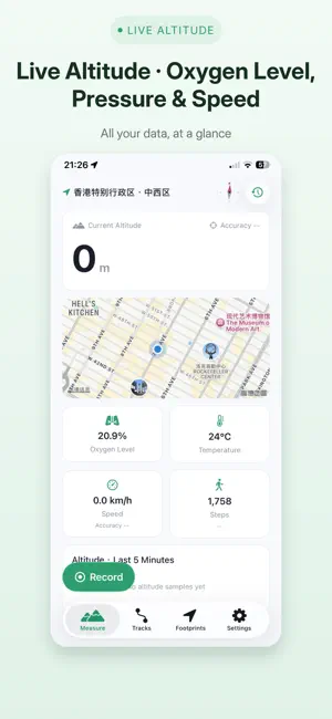
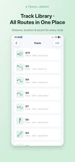
AltiView — the altitude and track recorder built for hiking, mountaineering, cycling and high-altitude travel. Raise your phone and know how high you are. [Live Altitude] GPS fused with the barometer shows your current altitude, pressure, relative elevation change, speed and oxygen level, plus altitude and pressure trends from the last 5 minutes. Every rise and fall, visible at a glance. [Track Recording] One tap to start, one tap to pause or save. Recording continues in the background or with the screen locked; the detail view lays out the elevation profile against distance, so every climb and descent is obvious. [3D Track Replay] Turn the route you walked into a 3D track: rotate, zoom and pan freely, with the line colored by altitude so the rhythm of the climb reads at a glance. Switch the ground between grid, map and satellite imagery, with ground projection. [Track Library] Every track in one place — distance, duration and ascent at a glance, ready to revisit any trip. Import GPX and KML, export GPX; your data stays yours. [Automatic Footprints] Low-power significant-location-change wakeups log the places you visit in the background, no manual check-in needed. Every point carries altitude, pressure, temperature, speed and location accuracy, and you can add photos and notes. [Record Comparison] Put any two records side by side: differences in altitude, distance and elapsed time, settled in one look. Same route — how much did this time differ from the last? Now you know. [Sharing and Backup] Generate a share card with your track stats, save it to Photos or send it to friends. Export tracks as GPX and footprints as CSV, and back everything up to iCloud for a full restore on a new device. [10 Languages, Metric or Imperial] Switch anytime between Simplified Chinese, Traditional Chinese, English, Japanese, Korean, French, German, Spanish, Italian and Russian. Altitude, distance and speed switch between metric and imperial units. — Whether you are summiting a snowy peak or recording a weekend hike, AltiView stands with you a little higher, looking back at every metre behind you. Terms of Use (EULA): https://www.apple.com/legal/internet-services/itunes/dev/stdeula/
What’s new
Version 1.1.0 · Updated October 25, 2026
· New Home Screen widgets for altitude, speed, pressure and more, plus a Lock Screen widget · Widgets show your latest measurement and open the matching page when tapped · New widget preview in Settings, so you can see the styles before adding them · Fixed the tracking permission prompt not appearing again after being interrupted by the location prompt · Improved ad loading timing at launch
App privacy
The developer, 仕华 罗, reported these privacy practices to Apple.
Data Used to Track You
The following data may be used to track you across apps and websites owned by other companies:
- Usage Data: Advertising Data
Data Not Linked to You
The following data, which may be collected but is not linked to your identity, may be used for the following purposes:
- Location: Coarse Location
- Identifiers: Device ID
- Usage Data: Product Interaction, Advertising Data
- Diagnostics: Crash Data, Performance Data
- Other Data: Other Data Types
Used for: Third-Party Advertising, App Functionality
Alternatives to AltiView: Altitude & Tracks
Looking for apps like AltiView: Altitude & Tracks? Here are 6 similar apps on the App Store. The highest rated is Yukitabi (5.0/5), and all 6 are free to download.
-
 Altitude Measurement
2.0
-
 Yukitabi
5.0
-
 Otobüs Nerede - Where's My Bus
-
 Tractor Field Navigator GPS
1.0
-
 Belfast International Airport
-
 World Map Offline
| App | Rating | Price | Last updated | Compare |
|---|---|---|---|---|
| AltiView: Altitude & Tracks | – | Free | October 25, 2026 | |
| Altitude Measurement | 2.0 / 5 (30) | Free | Oct 8, 2026 | Compare |
| Yukitabi | 5.0 / 5 (1) | Free | Oct 25, 2026 | Compare |
| Otobüs Nerede - Where's My Bus | – | Free | Oct 21, 2026 | Compare |
| Tractor Field Navigator GPS | 1.0 / 5 (1) | Free | Nov 13, 2024 | Compare |
| Belfast International Airport | – | Free | Oct 17, 2026 | Compare |
| World Map Offline | – | Free | Oct 22, 2026 | Compare |